- Aarberg
-
Aarberg Town center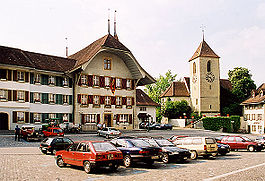
Country Switzerland 
Canton Bern District Seeland 47°2′N 7°16′E / 47.033°N 7.267°ECoordinates: 47°2′N 7°16′E / 47.033°N 7.267°E Population 4,088 (Dec 2010)[1] - Density 516 /km2 (1,335 /sq mi) Area 7.93 km2 (3.06 sq mi) Elevation 455 m (1,493 ft) Postal code 3270 SFOS number 0301 Mayor Arnold Stalder (as of 2008) FDP/PRD Surrounded by Bargen, Kappelen, Lyss, Radelfingen, Seedorf Website www.aarberg.ch
SFSO statistics
 Aarberg
View map of Aarberg Aarberg is a municipality in the Seeland administrative district in the canton of Bern in Switzerland.
Aarberg lies 20 kilometers from Bern above the Aar River. With an area of 7.93 km2 (3.06 sq mi), Aarberg borders Bargen, Kappelen, Lyss, Radelfingen and Seedorf.
Aarberg is not to be confused with Aarburg in Aargau or with Aarbergen in Germany.
The city was once located on an island with the Aar River and Little Aar River flowing around it. The old city grew up around the edge of the island with a large open plaza in the middle. In addition to the old city, Aarberg also includes the new outer quarter, and the villages of Spins, Mühletal and Grafenmoos.
Contents
History
County of Aarberg
Grafschaft AarbergState of the Holy Roman Empire ← 
ca 1220–1379  →
→Capital Aarberg Government Principality Historical era Middle Ages - City settled before 1138 - City and county founded ca 1220 - Gained town rights 1271 - Peter II attempts
to pawn county
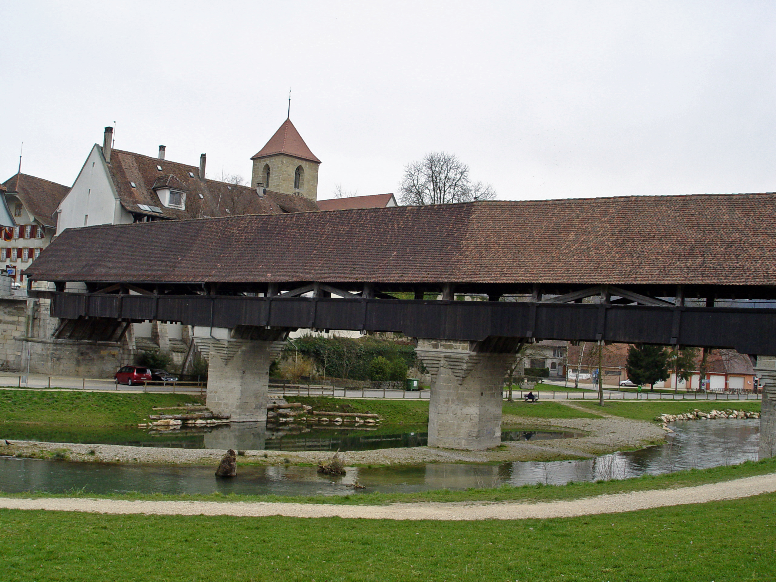
from 1358- Sold to Bern 1379  Bridge over the Aar River, built in 1568
Where Aarberg now stands was once an island surrounded by the Aar River and the Little Aar River. By 1138 there was a small pilgrim home and hospital with a bridge, the Bargenbrügg, over the Aar river. This bridge was a key river crossing from Bern to Büren an der Aare.[2]
The city itself was founded between 1220 and 1225 by count Ulrich III of Neuchâtel. The count had recently acquired the rulership over this region and needed a central location from which to rule. The island and the key bridge was a natural location for a town.[3] By the 14th century, Aarberg lay along the most important of the three trade roads in the region. The old roman roads that connected Solothurn, Aarberg and Murten as well as southern Germany with Lyon and Rome all passed near Aarberg.[2]
The oldest official seal of citizenship in the town dates from 1249. Ulrich IV reaffirmed the town privileges in 1271. Initially the town was unwalled with two rows of wooden houses around a central narrow plaza. Following fires in 1419 and 1477 the city was rebuilt in stone and set back about 10m creating the current, impressive central lens shaped plaza.[3]
The city was besieged in 1339, 1382 and 1386 but not taken. In 1358 the Graf (or Count) Peter von Aarberg was in financial difficulties and began looking for someone to buy the city. After years of unsuccessful attempts, in 1377-79 he was able to sell the city and his rights as ruler to Bern. In 1414, the toll on the bridges over the Aar as well as the expensive construction and repair on the bridges, was given to Bern. The bridges were rebuilt following floods in 1414, 1443, 1490, 1557 and the current bridge dates from 1567-68.
The church at Aarberg, which is on the western border of the Bishopric of Constance, was built in 1484. The church was rebuilt in 1575 on the site of the former castle of Aarberg. The tower of the church, built in 1526, is from stone salvaged from the demolished Pilgrim Hospital Church. The cemetery was located next to the new church. In 1418, Bern placed the church under the patronage of the Münster of Bern, however following the Protestant Reformation (1528) the patronage was withdrawn.
The government of the city was a mayor or Schultheiß and a 24-member council (12 nobles and 12 citizens) under a vogt who lived in the Amthaus (built in 1608-10) and had the rights of high justice.
Aarberg has always been in a unique position for trade. Its location over the Aar and near major trade roads made the business of the city revolve around trade. The large central market plaza in the city was one of the largest trans-shipment centers in Switzerland. Many transport companies and inns, including the Tavernen Krone (Crown) and Tavernen Falken (Falcon), grew up around the plaza. The yearly market (1271 mentioned, 1507 two per year, 1681 three per year, 1759 quarterly), by 1478 was an important market that drew salt, iron, steel and cloth merchants from the entire region.[3] The city also tried to expand into farming by purchasing Alp Chuffort ob Lignières, Spins and Mühletal.
The Napoleonic invasion of Switzerland in 1798 severely damaged the city. Under the Helvetic Republic Aarberg was included in the Zollikofen District, though this only lasted until 1803. After this Aarberg became the capital of the Bezirk or county of Aarberg. During the Paris July Revolution, in 1830, the commanders of the Swiss Army moved to Aarberg. The fortified city was a key strong point on the western border between Geneva and Basel.[3]
With the invention of the railroad and alterations to Jura rivers, everything changed for Aarberg. The Bern-Lyss-Biel rail line bypassed Aarberg completely, reducing the amount of trade flowing through the city. Neither the Broye Valley line (from Lyss to Lausanne, built in 1876) or the creation of paved roads made a major change. At the same time, the Hagneck canal diverted a portion of the Aar and prevented the periodic flooding of the city. The little Aar was dammed and Aarberg island became a hill.
During the 19th century business slowed in Aarberg, though the city grew. New quarters grew up in areas that had been covered by the Aar: Brückfeld, Leimernacher, Sunnmatt und Mühlau. Business shifted from transportation to farming, concrete construction and precision parts manufacturing.
Sights
The entire town and the covered bridge over the Aar are heritage sites of national significance.[4]
Plaza in the Old Town
The large round plaza in Aarberg is used for numerous markets, light shows and open air theatre. One of the most famous markets is the Puce or flea market. It is described as "one of the greatest and most atmospheric flea-markets in Switzerland."[5] Started in 1977, the Puce now has about 250 vendors selling a variety of products. The Puce takes place on the last weekend in April and August.
Schloss Aarberg
The castle was first built in 1220 with the town. From 1358 (when Aarberg was sold) until 1830 around 100 Vögte occupied the castle. Today it is the town hall, Bezirk (county) seat as well as the police station for the Cantonal police. The Hotel Krone is located on the left side of the castle.
Church
The late Gothic church was built in 1526 and promptly burned down. It was rebuilt in 1576 and is used by the Swiss Reformed Church. The bell tower is one of the tallest buildings in Aarberg. The church is built on a single nave plan with a choir. Both the pulpit and the organ are worth seeing.
Geography
Aarberg has an area, as of 2009[update], of 7.91 square kilometers (3.05 sq mi). Of this area, 3.51 km2 (1.36 sq mi) or 44.4% is used for agricultural purposes, while 2.34 km2 (0.90 sq mi) or 29.6% is forested. Of the rest of the land, 1.86 km2 (0.72 sq mi) or 23.5% is settled (buildings or roads), 0.18 km2 (0.069 sq mi) or 2.3% is either rivers or lakes and 0.03 km2 (7.4 acres) or 0.4% is unproductive land.[6]
Of the built up area, industrial buildings made up 5.8% of the total area while housing and buildings made up 10.0% and transportation infrastructure made up 4.4%. Power and water infrastructure as well as other special developed areas made up 1.1% of the area while parks, green belts and sports fields made up 2.1%. 27.9% of the total land area is heavily forested and 1.6% is covered with orchards or small clusters of trees. Of the agricultural land, 36.3% is used for growing crops and 6.7% is pastures, while 1.4% is used for orchards or vine crops. All the water in the municipality is in rivers and streams.[6]
Demographics
Aarberg has a population (as of 31 December 2010) of 4,088[1]. In 2007, 11.2% of the population were foreign nationals. Over the last 10 years the population has grown at a rate of 14.3%. Most of the population (as of 2000[update]) speaks German (90.5%), with Italian being second most common ( 1.4%) and Turkish being third ( 1.4%).
In the 2007 election the most popular party was SVP which received 35.9% of the vote. The next three most popular parties were the SPS (21.9%), the FDP (18.4%) and the Green (8.8%).
The age distribution of the population (as of 2000[update]) is children and teenagers (0–19 years old) make up 23.6% of the population, while adults (20–64 years old) make up 62% and the seniors (over 64 years old) make up 14.4%. In Aarberg about 76.3% of the population (between age 25-64) have completed either non-mandatory upper secondary education or additional higher education (either University or a Fachhochschule).
Aarberg has an unemployment rate of 1.16%. As of 2005[update], there were 104 people employed in the primary economic sector and about 23 businesses involved in this agricultural sector. 769 people are employed in the secondary sector and there are 49 businesses in this manufacturing sector. 1603 people are employed in the tertiary sector, with 178 businesses in the services sector.[7]
The historic population growth is given by the following table:
Year Inhabitants 1764 440[3] 1850 993[3] 1900 1372[3] 1950 2126[3] 1990 3414[3] 1991 3378[8] 2002 3907[8] 2004 3969[8] 2005 3952[8] 2006 3954[8] 2007 3945[8] Notable people from Aarberg
- Theodor Gohl, architect
- Kurt Wüthrich, chemist and professor of biophysics
- Martin Laciga, beach volleyball player
- Andreas Fuhrer, sidecarcross world champion 1993-96
- Diana Schwab, karateka
References
- ^ a b Swiss Federal Statistical Office - STAT-TAB, online database – Datenwürfel für Thema 01.2 - Bevölkerungsstand und -bewegung (German) accessed 29 September
- ^ a b Aarberg city webpage-History (German)
- ^ a b c d e f g h i Aarberg in German, French and Italian in the online Historical Dictionary of Switzerland.
- ^ Swiss inventory of cultural property of national and regional significance (1995), p. 101.
- ^ Puce Website
- ^ a b Swiss Federal Statistical Office-Land Use Statistics 2009 data (German) accessed 25 March 2010
- ^ Swiss Federal Statistical Office accessed 28-May-2009
- ^ a b c d e f Bundesamt fur Statistik (Federal Department of Statistics) (2008). "Bilanz der ständigen Wohnbevölkerung (Total) nach Bezirken und Gemeinden" (Microsoft Excel). http://www.bfs.admin.ch/bfs/portal/de/index/themen/01/02/blank/key/raeumliche_verteilung/kantone__gemeinden.html. Retrieved November 5, 2008.
External links
- Official website (German)
- de: Schloss Aarberg
- Aarberg in German, French and Italian in the online Historical Dictionary of Switzerland.
- Aarberg Tourism (limited English Content)
Municipalities in the Seeland administrative district, Switzerland Aarberg | Arch | Bangerten | Bargen | Brüttelen | Büetigen | Bühl | Büren an der Aare | Diessbach bei Büren | Dotzigen | Epsach | Erlach | Finsterhennen | Gals | Gampelen | Grossaffoltern | Hagneck | Hermrigen | Ins | Jens | Kallnach | Kappelen | Leuzigen | Lüscherz | Lyss | Meienried | Merzligen | Müntschemier | Niederried bei Kallnach | Oberwil bei Büren | Radelfingen | Rapperswil | Ruppoldsried | Rüti bei Büren | Schüpfen | Seedorf | Siselen | Studen (BE) | Täuffelen | Treiten | Tschugg | Vinelz | Walperswil | Wengi | Worben
Canton of Bern | Districts of Canton Bern | Municipalities of the canton of Bern
 Categories:
- Municipalities of Bern
- Municipalities of Switzerland
- Former principalities
- Former countries in Europe
- States of the Holy Roman Empire
- States and territories established in 1220
- States and territories disestablished in 1379
- Cities in Switzerland
- Aar drainage basin
- Canton of Bern
- Cultural property of national significance in the canton of Bern


Wikimedia Foundation. 2010.