- De Kalb, Missouri
-
De Kalb, Missouri — City — Location of De Kalb, Missouri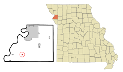
Coordinates: 39°35′17″N 94°55′31″W / 39.58806°N 94.92528°WCoordinates: 39°35′17″N 94°55′31″W / 39.58806°N 94.92528°W Country United States State Missouri County Buchanan Area – Total 0.3 sq mi (0.7 km2) – Land 0.3 sq mi (0.7 km2) – Water 0.0 sq mi (0.0 km2) Elevation 1,145 ft (349 m) Population (2000) – Total 257 – Density 1,017.0/sq mi (392.7/km2) Time zone Central (CST) (UTC-6) – Summer (DST) CDT (UTC-5) ZIP code 64440 Area code(s) 816 FIPS code 29-18946[1] GNIS feature ID 0730083[2] De Kalb is a city in Buchanan County, Missouri, United States. The population was 257 at the 2000 census, at which time it was a town. It is part of the St. Joseph, MO–KS Metropolitan Statistical Area.
Geography
De Kalb is located at 39°35′17″N 94°55′31″W / 39.58806°N 94.92528°W (39.588171, -94.925182)[3].
According to the United States Census Bureau, the town has a total area of 0.2 square miles (0.52 km2), all of it land.
Demographics
As of the census[1] of 2000, there were 257 people, 101 households, and 73 families residing in the town. The population density was 1,017.0 people per square mile (396.9/km²). There were 105 housing units at an average density of 415.5 per square mile (162.2/km²). The racial makeup of the town was 97.28% White, 0.78% Native American, and 1.95% from two or more races. Hispanic or Latino of any race were 0.39% of the population.
There were 101 households out of which 34.7% had children under the age of 18 living with them, 63.4% were married couples living together, 5.0% had a female householder with no husband present, and 27.7% were non-families. 24.8% of all households were made up of individuals and 14.9% had someone living alone who was 65 years of age or older. The average household size was 2.54 and the average family size was 3.04.
In the town the population was spread out with 25.7% under the age of 18, 8.2% from 18 to 24, 31.5% from 25 to 44, 19.1% from 45 to 64, and 15.6% who were 65 years of age or older. The median age was 34 years. For every 100 females there were 97.7 males. For every 100 females age 18 and over, there were 101.1 males.
The median income for a household in the town was $38,750, and the median income for a family was $49,688. Males had a median income of $33,750 versus $19,205 for females. The per capita income for the town was $18,880. About 3.2% of families and 3.0% of the population were below the poverty line, including none of those under the age of eighteen and 2.6% of those sixty five or over.
References
- ^ a b "American FactFinder". United States Census Bureau. http://factfinder.census.gov. Retrieved 2008-01-31.
- ^ "US Board on Geographic Names". United States Geological Survey. 2007-10-25. http://geonames.usgs.gov. Retrieved 2008-01-31.
- ^ "US Gazetteer files: 2010, 2000, and 1990". United States Census Bureau. 2011-02-12. http://www.census.gov/geo/www/gazetteer/gazette.html. Retrieved 2011-04-23.
Municipalities and communities of Buchanan County, Missouri Cities De Kalb | Dearborn‡ | Easton | Gower‡ | St. Joseph

Village Townships Unincorporated
communitiesFootnotes ‡This populated place also has portions in an adjacent county or counties
Categories:- Cities in Buchanan County, Missouri


Wikimedia Foundation. 2010.