- New Barbadoes Neck
-
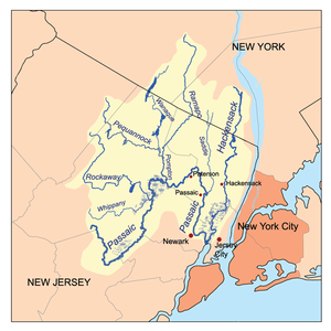
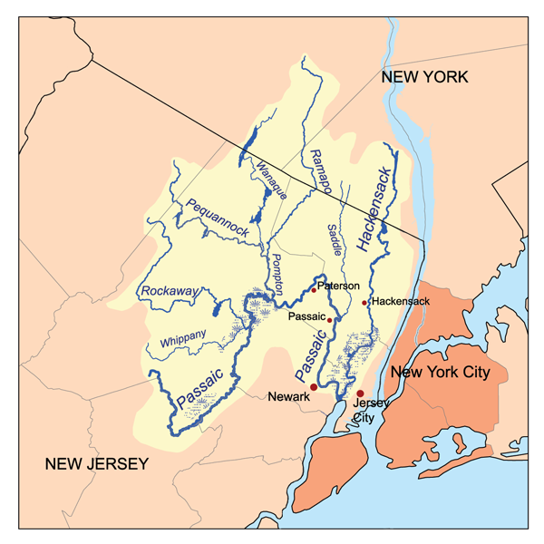
New Barbadoes Neck is the name given in the colonial era for the peninsula in northeastern New Jersey, USA between the lower Hackensack and Passaic Rivers, in what is now western Hudson County and southern Bergen County. The neck begins in the south at Kearny Point in the Newark Bay, and is characterized by a ridge (creating the valley of the Passiac) along the west and part of the New Jersey Meadowlands (the flood plain of the Hackensack) on the east.
Contents
Native Americans and Netherlanders
The neck was part of an area called Meghgectecock by the Lenape, was the territory of the group called the Hackensack.[1][2] The name of masgichteu-cunk meaning where May-apples grow, from a moist-woodland perennial that bears edible yellow berries. The name Achter Col was given during the New Netherland era in the mid-17th century, and can be translated a rear mountain pass or behind the ridge, in reference to the access it provided to the hinterlands beyond the Hudson Palisades that were rich fur-trapping grounds.
British land grants
After the surrender of Fort Amsterdam by the Dutch in 1664 the area became part of the Province of New Jersey during the period of British colonization of North America. On July 4, 1668, a Crown Grant of 30,000 acres (120 km²) obtained by Major William Sandford, who named the area New Barbadoes after his old home the Caribbean island. As was the custom of the times, the Major paid Chief Tantaqua of the Hackensack Indians 20 English Pounds Sterling for all their reserve rights and titles. William Sandford died in 1690. In 1708, his friend Major Nathaniel Kingsland took over the upper western tract of the Grant.[3] He is recalled in the Kingsland Station, Kingsland Avenue in Lyndhurst, and Kingsland Manor.
To the north, a large patent was also made to Captain John Berry who had also emigrated from the island of Barbadoes to take up residence.[4] It is likely the border was at Union Avenue in today's Rutherford.[5] He is recalled in the names of Berrys Creek, and the historic Yereance-Berry House. A portion was later sold to an early settler to Pavonia, New Netherland, Walling Van Winkle.
New Barbadoes Township
Main article: New Barbadoes Township, New JerseyThe township was created was created in 1710 and encompassed all of the neck as well as lands to the north and west to the Saddle River. At this time the territory was transferred from Essex County and made part of an expanded Bergen County.[6]
Copper mine and steam engine
In 1710, Kingsland sold the a tract for 300 English Pounds Sterling to Captain Arent Schuyler, a former trader and Indian agent, and a member of the influential Schuyler family. The new purchase included present-day Kearny, North Arlington, and Lyndhurst. Following his death in 1730, his sons inherited the land. After Schuyler's purchase of his new homestead, it was discovered the ground contained copper which led to the opening of a mine. After it became flooded the first steam engine in America was developed and used to pump out the deep mine shaft.[7] The engine was secretly built by the engineer Josiah Hornblower. The engine and mines were destroyed by fire in 1768 and remained idle for some years.[8] Schuyler Avenue, which runs along the eastern edge of the ridge honors the early settlement.
Revolutionary era
Lord Howe of England took possession of New York Harbor and the proximity of Schuyler Mansion drew many of his officers who traveled over a road known today as the Belleville Turnpike. It had originally been laid in 1759 with cedar logs from the nearby swamps. In September 1777, Henry Clinton, head of the British Expeditionary Forces in America, selected Schuyler Mansion for his headquarters during one of his more important raiding operations, including those along of Second River.[9]
Eighteen-hundreds civic borders
In the 1800s the Neck came under the jurisdiction of different townships and in 1840 part of the newly created Hudson County.
Further information: Lodi Township, New JerseyFurther information: Harrison Township, New JerseyFurther information: Union Township, Bergen County, New JerseyMeadowlands development and preservation
A large portion of the peninsula has since 1968 been part of the New Jersey Meadowlands District
Further information: Hackensack Meadowlands Development CommissionFurther information: Meadowlands Sports ComplexFurther information: Meadowlands Environment CenterSee also
References
- ^ New Jersey Colonial Records, East Jersey Records: Part 1-Volume 21, Calender of Records 1664-1702
- ^ http://www.barbarakrasner.com/images_of_america__kearny__new_jersey_24860.html
- ^ Harvey, Cornelius Burnham (1900). "Early Settlers of Bergen County". Genealogical History of Hudson and Bergen Counties New Jersey. Getnj.com. http://www.getnj.com/hudberg/hudberg5.shtml. Retrieved 2010-09-18.
- ^ Harvey, Cornelius Burnham (1900). "Early Settlers of Bergen County". Genealogical History of Hudson and Bergen Counties New Jersey. Getnj.com. http://www.getnj.com/hudberg/hudberg6.shtml. Retrieved 2010-09-18.
- ^ JOHN W. BARBER and HENRY HOWE (1844). "Townships of Bergen County". HISTORICAL COLLECTIONS OF THE STATE OF NEW JERSEY. S. Tuttle (New York). http://www.getnj.com/hudberg/hudberg6.shtml. Retrieved 2010-09-22.
- ^ JOHN W. BARBER and HENRY HOWE (1844). "Townships of Bergen County". HISTORICAL COLLECTIONS OF THE STATE OF NEW JERSEY. S. Tuttle (New York). http://www.getnj.com/hudberg/hudberg6.shtml. Retrieved 2010-09-22.
- ^ "Manuscript group 651: Schuyler Family". New Jersey Historical Society. http://www.jerseyhistory.org/findingaid.php?aid=0651. Retrieved 2010-09-18.
- ^ Lienhard, John H.. "No 1085 America's First Steam Engine". Engines of our Ingenuity. http://www.uh.edu/engines/epi1085.htm. Retrieved 2010-09-18.
- ^ http://www.state.nj.us/dep/njgs//enviroed/oldpubs/battles.pdf
Categories:- Geography of Bergen County, New Jersey
- Pre-state history of New Jersey
- Populated places established in 1693
- Peninsulas of New Jersey
- Geography of Hudson County, New Jersey
- Kearny, New Jersey
- New Jersey Meadowlands District
Wikimedia Foundation. 2010.