- Cranebrook, New South Wales
-
Cranebrook
Sydney, New South Wales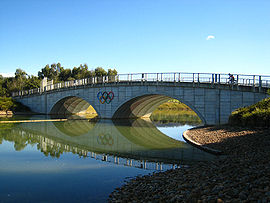
Sydney International Regatta CentrePopulation: 14,263 (2001) Established: 1804 Postcode: 2749 Location: 65 km (40 mi) west of Sydney CBD LGA: Penrith City Council State District: Londonderry Federal Division: Lindsay Suburbs around Cranebrook: Castlereagh Londonderry Londonderry Castlereagh Cranebrook Llandilo Mount Riverview Penrith Cambridge Gardens Cranebrook is a suburb of Sydney, in the state of New South Wales, Australia. Cranebrook is located 65 kilometres west of the Sydney central business district, in the local government area of the City of Penrith and is part of the Greater Western Sydney region.
It is surrounded by the rural suburbs of Castlereagh, Llandilo and Londonderry and has come to incorporate the Mount Pleasant housing estate, long regarded as a separate suburb.
Contents
History
Cranebrook takes its name from a pioneer farmer, James McCarthy, who was granted 100 acres (400,000 m²) of land in 1804 and named it "Crane Brook farm", after the abundance of cranes in the area. James McCarthy started a cemetery in 1804. After his four year old daughter died, he set aside some land to bury her in what became one of the first Catholic cemeteries in Australia.[1]
Geography
Cranebrook's geography is hilly and so many residents on the western side enjoy views across the Nepean River to the Blue Mountains. Residents on the eastern side enjoy views across the ADI Site, an area rich in Cumberland Woodland and populated with many kangaroos.
In the eastern side of Cranebrook, The Northern Road separates Cranebrook from an area of land known as the ADI Site, around 15 square kilometres in size. Aspects relating to the sale and development of this land have been a strong local political issue. The south side of Cranebrook is bounded by Andrews Road and the north side of Cranebrook is bounded by Smeeton Road. Nearby is McCarthys Lane Cemetery, considered the oldest Catholic cemetery in Australia.
Penrith Lakes
The western side of Cranebrook features the Penrith Lakes Scheme, a series of flooded quarries. The quarries were formed by a quarrying conglomerate in 1979. The site supplies around 75% of Sydney’s sand and crushed aggregate requirements, including about 85% of the materials for ready mixed concrete. One of these lakes is the Sydney International Regatta Centre which hosted the rowing events of the Sydney 2000 Olympics. There is also the popular Penrith Whitewater Stadium which hosted whitewater slalom events for the Sydney 2000 Olympics.
It is a popular misconception that these lakes are filled via the Nepean River but they are actually filled via rain water and ground water. When the Nepean River floods, the lakes system can act as a weir. A Penrith Lakes Scheme Concept Plan [2] is currently under review to ensure the site delivers a wide range of environmental, social, cultural and economic values. Penrith Lakes has established a community advisory committee (CAC) which will meet regularly and provide advice to Penrith Lakes on the ongoing planning and development of the lakes scheme.
Commercial area
The main commercial area of Cranebrook is on Borrowdale Way which features a shopping centre and some parkland.
Transport
Residents of Cranebrook can access Penrith by traveling south on The Northern Road or Castlereagh Road. The trip by car is about 5 minutes. Residents can also travel to Windsor and Richmond to the north, which are about 10–15 minutes by car. The distance to the Sydney CBD is 65 km and this is best traveled by either driving down The Northern Road to the M4 Motorway or taking a train from Penrith Railway Station. Cranebrook itself has no train station (the nearest station is Penrith), however the area is serviced by buses which can take residents into Penrith.
Schools
The three public primary schools are Braddock Public School, Henry Fulton Public School and Samuel Terry Public School. The local public high school is Cranebrook High School. At one point Xavier College was based in Cranebrook, while construction of its permanent site in Llandilo was developed.
The Catholic primary school is Corpus Christi, located in northern Cranebrook. A non-denominational Christian private school, St Paul's Grammar School, offers the IB Diploma Programme.
Churches
There are two churches in Cranebrook: Corpus Christi Catholic Church on Andromeda Drive and St Thomas' Anglican Church on Callisto Drive.
Housing
Cranebrook is a largely residential area. It contains mostly medium-density housing and some low-density semi-rural housing towards the north. Whilst some of the semi-rural areas would date to when Cranebrook was first founded, much of the medium-density development has occurred within just the last 15 years. Even today there is a regular new home construction.
As such, the population is typically local families, many of whom are home-owners or aspiring home-owners. Suburbs like Cranebrook are often considered part of the mortgage belt of Western Sydney. There are some units and semi-detached houses in the Mount Pleasant area, though the majority are detached with good size house blocks, well kept gardens and abundant mature native trees.
Politics
The state government electorates are Londonderry and Penrith. It is in the Northern Ward of the local government area of the City of Penrith. The Aboriginal district is the Deerubbin Local Aboriginal Land Council Area.
References
- ^ http://www.penrithcity.nsw.gov.au/index.asp?id=969 Penrith Local Suburb Profiles
- ^ penrithlakes.com.au
External links
- Penrith Lakes Development Corporation
- Penrith WhiteWater Stadium
- Sydney International Regatta Centre
- St Paul's Grammar School
- Penrith City Council - Local Suburb Profiles - Cranebrook
- Cranebrook, New South Wales is at coordinates 33°43′15″S 150°42′47″E / 33.72088°S 150.71302°ECoordinates: 33°43′15″S 150°42′47″E / 33.72088°S 150.71302°E
Suburbs of the City of Penrith | Western Sydney | Sydney Agnes Banks* · Badgerys Creek* · Berkshire Park · Cambridge Gardens · Cambridge Park · Castlereagh · Claremont Meadows · Colyton · Cranebrook · Emu Heights · Emu Plains · Erskine Park · Glenmore Park · Jamisontown · Kemps Creek* · Kingswood · Leonay · Llandilo · Londonderry · Luddenham* · Mount Vernon · Mulgoa · North St Marys · Orchard Hills · Oxley Park · Penrith · Regentville · St Clair · St Marys · South Penrith · Wallacia* · Werrington · Werrington County · Werrington DownsList of Sydney suburbs Categories:- Suburbs of Sydney
- 1804 establishments in Australia

Wikimedia Foundation. 2010.