- Cromwell, Minnesota
-
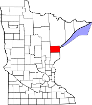
Cromwell, Minnesota — City — Location of Cromwell, Minnesota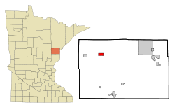
Coordinates: 46°40′47″N 92°52′37″W / 46.67972°N 92.87694°W Country United States State Minnesota County Carlton Area – Total 2.0 sq mi (5.2 km2) – Land 1.8 sq mi (4.7 km2) – Water 0.2 sq mi (0.5 km2) Elevation 1,312 ft (400 m) Population (2010)[1] – Total 234 – Density 78.7/sq mi (30.4/km2) Time zone Central (CST) (UTC-6) – Summer (DST) CDT (UTC-5) ZIP code 55726 Area code(s) 218 FIPS code 27-13780[2] GNIS feature ID 0642448[3] Cromwell is a city in Carlton County, Minnesota, United States. The population was 234 at the 2010 census.[1]
Minnesota State Highways 73 and 210 are two of the main arterial routes in the community.
Contents
Geography
According to the United States Census Bureau, the city has a total area of 2.0 square miles (5.2 km2), of which, 1.8 square miles (4.7 km2) of it is land and 0.2 square miles (0.52 km2) of it (9.45%) is water.
Demographics
As of the census[2] of 2000, there were 143 people, 65 households, and 39 families residing in the city. The population density was 78.7 people per square mile (30.3/km²). There were 94 housing units at an average density of 51.7 per square mile (19.9/km²). The racial makeup of the city was 97.20% White, 0.70% Native American, and 2.10% from two or more races. Hispanic or Latino of any race were 0.70% of the population. 36.7% were of Finnish, 21.1% German, 14.7% Norwegian and 6.4% Swedish ancestry according to Census 2000.
There were 65 households out of which 21.5% had children under the age of 18 living with them, 52.3% were married couples living together, 9.2% had a female householder with no husband present, and 38.5% were non-families. 35.4% of all households were made up of individuals and 13.8% had someone living alone who was 65 years of age or older. The average household size was 2.20 and the average family size was 2.88.
In the city the population was 22.4% under the age of 18, 4.2% from 18 to 24, 25.9% from 25 to 44, 25.2% from 45 to 64, and 22.4% who were 65 years of age or older. The median age was 44 years. For every 100 females there were 113.4 males. For every 100 females age 18 and over, there were 109.4 males.
The median income for a household in the city was $25,000, and the median income for a family was $31,875. Males had a median income of $26,250 versus $21,250 for females. The per capita income for the city was $16,605. There were 15.4% of families and 20.3% of the population living below the poverty line, including 33.3% of under eighteens and 7.9% of those over 64.
School
Cromwell-Wright school consists of both an elementary school and a high school.
References
- ^ a b "2010 Census Redistricting Data (Public Law 94-171) Summary File". American FactFinder. U.S. Census Bureau, 2010 Census. http://factfinder2.census.gov/faces/tableservices/jsf/pages/productview.xhtml?pid=DEC_10_PL_GCTPL2.ST13&prodType=table. Retrieved 23 April 2011.
- ^ a b "American FactFinder". United States Census Bureau. http://factfinder.census.gov. Retrieved 2008-01-31.
- ^ "US Board on Geographic Names". United States Geological Survey. 2007-10-25. http://geonames.usgs.gov. Retrieved 2008-01-31.
Municipalities and communities of Carlton County, Minnesota Cities Barnum | Carlton | Cloquet | Cromwell | Kettle River | Moose Lake | Scanlon | Thomson | Wrenshall | Wright
Townships Atkinson | Automba | Barnum | Beseman | Blackhoof | Eagle | Holyoke | Kalevala | Lakeview | Mahtowa | Moose Lake | Perch Lake | Silver | Silver Brook | Skelton | Split Rock | Thomson | Twin Lakes | Wrenshall
Unorganized
territoriesUnincorporated
communitiesAtkinson | Automba | Duesler | Esko | Harney | Holyoke | Iverson | Mahtowa | Nemadji | Otter Creek | Pleasant Valley | Sawyer | Scotts Corner
Indian
reservationsFootnotes ‡This populated place also has portions in an adjacent county or counties
Coordinates: 46°40′51″N 92°53′03″W / 46.68083°N 92.88417°W
Categories:- Populated places in Carlton County, Minnesota
- Cities in Minnesota


Wikimedia Foundation. 2010.