- Nemadji, Minnesota
-
Nemadji — Unincorporated community — 
 Nemadji
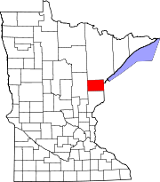
Coordinates: 46°28′46″N 92°35′41″W / 46.47944°N 92.59472°WCoordinates: 46°28′46″N 92°35′41″W / 46.47944°N 92.59472°W Country United States State Minnesota County Carlton County Township Barnum Township Elevation 1,060 ft (323 m) ZIP code 55707 Area code(s) 218 GNIS feature ID 0654843 Nemadji is a small unincorporated community in Barnum Township, Carlton County, Minnesota, United States. It lies east of the cities of Barnum and Moose Lake.
Carlton County Roads 8 and 11 are two of the main routes in the community.
The Nemadji River flows through the area.
Further reading
- Official State of Minnesota Highway Map - 2007/2008 edition
- Minnesota DOT map of Carlton County (2006)
Municipalities and communities of Carlton County, Minnesota Cities Barnum | Carlton | Cloquet | Cromwell | Kettle River | Moose Lake | Scanlon | Thomson | Wrenshall | Wright
Townships Atkinson | Automba | Barnum | Beseman | Blackhoof | Eagle | Holyoke | Kalevala | Lakeview | Mahtowa | Moose Lake | Perch Lake | Silver | Silver Brook | Skelton | Split Rock | Thomson | Twin Lakes | Wrenshall
Unorganized
territoriesUnincorporated
communitiesAtkinson | Automba | Duesler | Esko | Harney | Holyoke | Iverson | Mahtowa | Nemadji | Otter Creek | Pleasant Valley | Sawyer | Scotts Corner
Indian
reservationsFootnotes ‡This populated place also has portions in an adjacent county or counties
Categories:- Arrowhead region geography stubs
- Populated places in Carlton County, Minnesota
- Unincorporated communities in Minnesota


Wikimedia Foundation. 2010.