- Columbus Drive (Chicago)
-
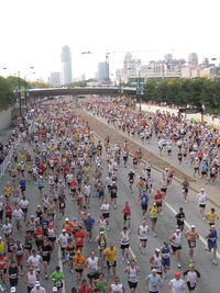
Columbus Drive 254 East Location: Chicago 2007 Chicago Marathon
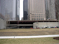
 Looking west at the three-level Columbus Drive from Lakeshore East
Columbus Drive is a north-south street in Chicago, Illinois which bisects Grant Park. It is 254 E in Chicago's street numbering system. Its south end is an interchange with Lake Shore Drive (US 41) at Soldier Field. North of Illinois Street it becomes Fairbanks Court and continues north ending at Chicago Avenue.
Roadway
In the Illinois Center development, the main lanes of Columbus are on the middle level of a three-level structure. That level intersects with the middle levels of Randolph Street, Lake Street, South Water Street and Wacker Drive. All these streets also exist on the lower and upper levels, except for Lake, which is a pedestrian mall on the upper level; both of these levels go only from Randolph to Wacker. Ramps are connected directly to Columbus at the following points:
- Southbound downramp and northbound upramp between the lower and middle levels, between Randolph and Lake; no access from the upramp to Lake
- Westbound downramp and eastbound upramp in the middle of South Water between the lower and middle levels, just west of Columbus
- Westbound upramp from the service (lowest) level at Wacker to middle Wacker west of Stetson Avenue (which quickly goes back down to become lower Wacker)
Columbus Drive crosses the Chicago River on the Columbus Avenue Bridge, a bascule bridge. North of the river, it crosses the upper level of North Water Street and passes over the lower level before going down to ground level at Illinois Street.
History
Columbus originally only went south from Monroe Street, south of Illinois Center. In 1980, it was extended to Wacker, including the three-level portion, and it was built over the Chicago River in 1982, connecting to Fairbanks Court. In 1992 the upper level of North Water was built.
See also
City of Chicago Chicago metropolitan area · State of Illinois · United States of America Architecture · Beaches · Climate · Colleges and Universities · Community areas · Culture · Demographics · Economy · Flag · Freeways · Geography · Government · History · Landmarks · Literature · Media · Music · Neighborhoods · Parks · Public schools · Skyscrapers · Sports · Theatre · Transportation
 Category ·
  Portal
Coordinates: 41°52′47″N 87°37′15″W / 41.8796°N 87.6207°W
Categories:- Streets in Chicago, Illinois
- Chicago, Illinois stubs
- Midwestern United States road stubs
- Illinois stubs
Wikimedia Foundation. 2010.


