- Dinkelland
-
Dinkelland — Municipality — 
Flag
Coat of arms
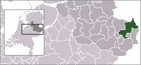
Country Netherlands Province Overijssel Area(2006) - Total 176.81 km2 (68.3 sq mi) - Land 175.78 km2 (67.9 sq mi) - Water 1.02 km2 (0.4 sq mi) Population (1 January, 2007) - Total 26,065 - Density 148/km2 (383.3/sq mi) Source: CBS, Statline. Time zone CET (UTC+1) - Summer (DST) CEST (UTC+2)  Dinkelland is a municipality in the eastern Netherlands. For a short time it was known as Denekamp (one of its component towns) until it was renamed in 2002.
Population centres
Breklenkamp, Denekamp, Deurningen, Groot Agelo, Het Stift, Klein Agelo, Lattrop, Noord Deurningen, Nutter, Ootmarsum, Oud Ootmarsum, Rossum, Saasveld, Tilligte, Weerselo.
External links
- Official website (Dutch)
 Municipalities of Overijssel
Almelo · Borne · Dalfsen · Deventer · Dinkelland · Enschede · Haaksbergen · Hardenberg · Hellendoorn · Hengelo · Hof van Twente · Kampen · Losser · Oldenzaal · Olst-Wijhe · Ommen · Raalte · Rijssen-Holten · Staphorst · Steenwijkerland · Tubbergen · Twenterand · Wierden · Zwartewaterland · Zwolle

See also Netherlands · Provinces · Municipalities Coordinates: 52°22′N 6°55′E / 52.367°N 6.917°E
Categories:- Populated places in Overijssel
- Municipalities of Overijssel
- Overijssel geography stubs


Wikimedia Foundation. 2010.