- Steenwijkerland
Infobox Settlement
official_name = Steenwijkerland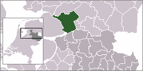
mapsize = 280px
subdivision_type = Country
subdivision_name =Netherlands
subdivision_type1 = Province
subdivision_name1 =Overijssel
area_footnotes = (2006)
area_total_km2 = 321.69
area_land_km2 = 291.12
area_water_km2 = 30.56
population_as_of =1 January ,2007
population_note = Source: CBS, [http://statline.cbs.nl/ Statline] .
settlement_type = Municipality
population_total = 43119
population_density_km2 = 148
timezone = CET
utc_offset = +1
timezone_DST = CEST
utc_offset_DST = +2.
ituation, economy
The municipality forms the entire northwesterly corner of the province. This area is called in Dutch: de kop van Overijssel (the head of Overijssel). It borders to the province
Friesland . The "capital"of the municipality,Steenwijk , with a population of about 17,100, is situated on the A32 motorway (Zwolle -Meppel -Leeuwarden ) and has a railway station on the line connecting those same cities.Steenwijk is the economic and administrative centre of the region. Many smaller trading and industrial enterprises are housed here, as well as a hospital and some secondary schools.Vollenhove has a shipyard, where very exclusive
yacht s are built.All over the area, partially being belowsea level , the soil is somewhat swampy. Many Steenwijkerland farmers only raise cattle. The soil is too wet to grow corn or wheat. However, the wetlands also have an advantage: many nature or water sports loving tourist come to the municipality.Population centres
The more important places are printed in bold types. In brackets: estimated population,on January 1th, 2006.
*Baarlo
*Baars
*Barsbeek
*Basse
*Belt-Schutsloot
*Blauwe Hand
*Blokzijl ( 1,400)
*De Bult
*De Klosse
*De Kolk
*De Pol
*Doosje
*Dwarsgracht - like Nederland and Muggenbeet, a small village much like Giethoorn, however more remote
*Eesveen
*Giethoorn (2,600)
*Heetveld
*Kadoelen
*Kalenberg
*Kallenkote
*Kuinre
*Leeuwte
*Marijenkampen
*Moespot
*Muggenbeet
*Nederland, Overijssel
*Oldemarkt (2,600)
*Onna, Overijssel
*Ossenzijl
*Paasloo
*Roekebosch
*Ronduite
*Scheerwolde
*Sint Jansklooster (2,400)
*Steenwijk (17,100)
*Steenwijkerwold (1,900)
*Tuk - like Zuidveen now a suburb of Steenwijk ( 1,600)
*Vollenhove (4,100)
*Wanneperveen (1,600)
*Wetering
*Willemsoord
*Witte Paarden
*Zuidveen .ights
* The city of Steenwijk can be visited for daily shopping, going to the market, etc. Don't expect exclusive or extremely "trendy" shops!
* In Steenwijk the villa "Ramswoerthe", built in 1899 inJugendstil architecture, and its park can be visited.
* Blokzijl has a smallmarina , surrounded by picturesque old brick houses from the 17th century, looking like miniatures of theAmsterdam canal houses.
* Vollenhove has two remarkable old churches (15th and 17th century) , the castle ruins of Toutenburg with a park, the estate Old Ruitenborgh (18th century; small hotel with a good restaurant) and several old houses, of which the former Latin School (17th century) is the most beautiful.
* Giethoorn and Dwarsgracht are picturesque due to their local structure (see above); many of the old farmhouses have been transformed into "second homes" where rich Dutchmen live during their holidays. In summer, most houses of the village are lit in the evening, which enables the Tourist Board to organise romantic guided boat tours. Of course, a yacht-basin, restaurants and camping sites are there as well.
* Between Kuinre and Steenwijk lies the National Park "De Weerribben", a very valuablewetland area with bogs, swamps, small canals and meadows. It can be visited on guided tours. The entrance is in Ossenzijl. For information ask the VVV (Tourist Board) or the owner, the "Natuurmonumenten" organization (on their website, type under: Zoeken ( = Search) the name of the area).
* A similar natural reserve called "De Wieden",is situated in the southern part of the municipality. An information centre is situated in St. Jansklooster near Vollenhove. "Wieden" means: wide places, wide lakes. These lakes are suitable for sailing,windsurfing etc.External links
* [http://www.steenwijkerland.nl Official Website of Steenwijkerland] (only Dutch)
* [http://www.natuurmonumenten.nl Website of "Natuurmonumenten", the biggest Dutch nature protection organization, with elaborate descriptions of its natural reserves and walking routes] (only Dutch)
* [http://www.vvvkopvanoverijssel.nl Tourist Board of the region] (Dutch, German)
* [http://www.npdeweerribben.nl National Park De Weerribben] (partially in English)----
Wikimedia Foundation. 2010.