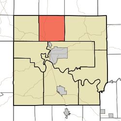
- Marshall Township, Lawrence County, Indiana
-
Marshall Township — Township — Location in Lawrence County Coordinates: 38°56′34″N 86°30′53″W / 38.94278°N 86.51472°WCoordinates: 38°56′34″N 86°30′53″W / 38.94278°N 86.51472°W Country  United States
State  Indiana
County Lawrence Government - Type Indiana township Area - Total 36.34 sq mi (94.12 km2) - Land 36.33 sq mi (94.08 km2) - Water 0.02 sq mi (0.04 km2) 0.04% Elevation 495 ft (151 m) Population (2000) - Total 4,551 - Density 125.3/sq mi (48.4/km2) ZIP codes 47420, 47421, 47451, 47462 GNIS feature ID 0453615 Marshall Township is one of nine townships in Lawrence County, Indiana, USA. As of the 2000 census, its population was 4,551.[1]
Contents
Geography
According to the United States Census Bureau, Marshall Township covers an area of 36.34 square miles (94.1 km2); of this, 36.33 square miles (94.1 km2) (99.96 percent) is land and 0.02 square miles (0.052 km2) (0.04 percent) is water.
Unincorporated towns
- Avoca at 38°54′43″N 86°32′52″W / 38.9119941°N 86.5477729°W
- Coveyville at 38°58′24″N 86°28′21″W / 38.9733828°N 86.4724935°W
- Guthrie at 38°58′36″N 86°30′33″W / 38.9767158°N 86.5091614°W
- Judah at 38°57′39″N 86°32′14″W / 38.9608824°N 86.5372176°W
- Logan at 38°56′32″N 86°30′29″W / 38.9422718°N 86.5080499°W
- Murdock at 38°54′35″N 86°30′30″W / 38.9097722°N 86.5083272°W
- Needmore at 38°55′38″N 86°31′48″W / 38.9272718°N 86.5299948°W
- Peerless at 38°55′28″N 86°30′12″W / 38.9244943°N 86.5033272°W
- Stemm at 38°57′25″N 86°30′15″W / 38.9569938°N 86.504161°W
- Thornton at 38°55′00″N 86°30′05″W / 38.9167167°N 86.5013827°W
(This list is based on USGS data and may include former settlements.)
Cemeteries
The township contains these six cemeteries: Anderson, Brinegar, Hayes, Hopkins, Mount Zion and Perkins.
Major highways
School districts
- North Lawrence Community Schools
Political districts
- Indiana's 4th congressional district
- State House District 65
- State Senate District 44
References
- "Marshall Township, Lawrence County, Indiana". Geographic Names Information System, U.S. Geological Survey. http://geonames.usgs.gov/pls/gnispublic/f?p=gnispq:3:::NO::P3_FID:0453615. Retrieved 2009-10-08.
- United States Census Bureau 2008 TIGER/Line Shapefiles
- IndianaMap
External links
- Indiana Township Association
- United Township Association of Indiana
- City-Data.com page for Marshall Township

Indian Creek Township, Monroe County Clear Creek Township, Monroe County Polk Township, Monroe County 
Perry Township 
Pleasant Run Township  Marshall Township

Indian Creek Township Shawswick Township Municipalities and communities of Lawrence County, Indiana County seat: Bedford Cities Town Townships Bono | Guthrie | Indian Creek | Marion | Marshall | Perry | Pleasant Run | Shawswick | Spice Valley
Unincorporated
communitiesAvoca | Bartlettsville | Bono | Bryantsville | Buddha | Coveyville | Coxton | Dark Hollow | East Oolitic | Erie | Fayetteville | Fort Ritner | Georgia | Guthrie | Hartleyville | Heltonville | Huron | Judah | Lawrenceport | Leesville | Logan | Moorestown | Murdock | Needmore | Patton Hill | Peerless | Pinhook | Popcorn | Rabbitville | Rivervale | Shawswick | Silverville | Spring Mill Village | Springville | Stonington | Tarry Park | Tunnelton | Williams | Yockey | Zelma
Categories:- Townships in Lawrence County, Indiana
Wikimedia Foundation. 2010.

