- Indiana State Road 54
Infobox road
state=IN
type=IN
route=54
alternate_name=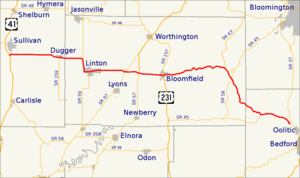
length_mi=65.2
length_round=1
length_ref= [http://illi-indi.com/EndsPage.php?id=1054§ion=1 Indiana Highway Ends - SR 54] ]
established=
direction_a=West
starting_terminus=
junction=
direction_b=East
ending_terminus=
counties=Greene, Lawrence, Sullivan
previous_type=IN
previous_route=53
next_type=IN
next_route=55State Road 54 is an east-west road in
Central Indiana . It runs from Sullivan in the west to the Oolitic area in the east, a distance of approximately 65 miles.Cities and towns served by SR 54 include, from west to east:
* Sullivan
* Dugger
* Linton
* Switz City
* Bloomfield
* OooliticMajor intersections
Source: INDOT Roadway Referencing System [ [http://www.in.gov/indot/3361.htm INDOT Roadway Referencing System] ] INint
county=Sullivan
cspan=2
mile=0.00
road=
location=Sullivan County
notes=SR 54 beginsINint
mile=8.37
road=
location=DuggerINint
county=Greene
cspan=9
mile=12.55
road=
type=concur
notes=concurrency begins
location=Greene CountyINint
mile=15.37
road=
type=concur
notes=concurrency ends after 2.82 miles
location=LintonINint
mile=21.30
road=
location=Switz CityINint
mile=23.80
road=
type=concur
notes=concurrency begins
location=Greene County
lspan=2INint
mile=27.80
road=
type=concur
notes=concurrency ends after 4 milesINint
mile=39.40
road=
location=BloomfieldINint
mile=39.62
road=
location=Greene County
lspan=3INint
mile=41.17
road=
type=concur
notes=concurrency beginsINint
mile=41.31
road=
type=concur
notes=concurrency ends after 0.14 milesINint
county=Lawrence
cspan=2
mile=49.91
road=
type=concur
notes=concurrency begins
location=Lawrence County
lspan=2INint
mile=55.17
road=
type=concur
notes=SR 54 endsReferences

Wikimedia Foundation. 2010.