- Muttaburra, Queensland
-
Muttaburra
Queensland
 Muttaburra
Population: 106[1] Established: 1878 Postcode: 4732 Location: - 1224 km (761 mi) WNW of Brisbane
- 731 km (454 mi) W of Rockhampton
- 114 km (71 mi) N of Longreach
LGA: Barcaldine Region State District: Gregory Federal Division: Flynn 
Muttaburra (
 /ˈmʌtəbʌrə/) is a small grazing town located in central western Queensland, Australia. The town is located on the banks of the Thomson River, approximately 120 kilometres (75 mi) north of the town of Longreach and 84 kilometres (52 mi) north of Aramac. Muttaburra is located within the Barcaldine Region. At the 2006 census, Muttaburra and the surrounding area had a population of 106.[1]
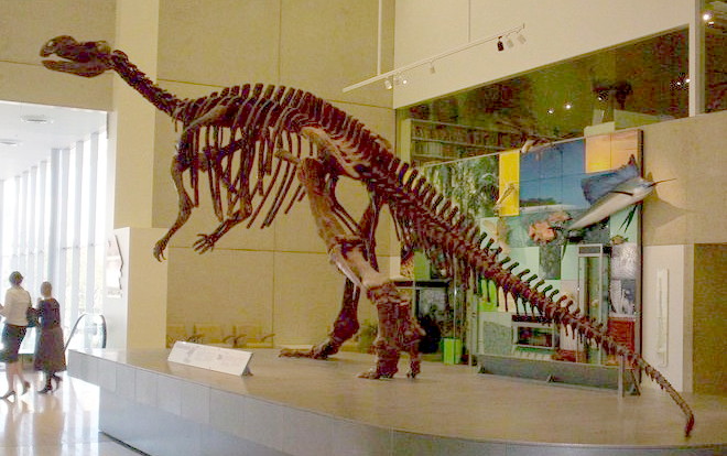
Muttaburra also has claims to fame, it was the discovery site of the Muttaburrasaurus, one of Australia's largest dinosaurs in 1963.[2] The creature is believed to have been 12 metres (39 ft) long, 2 metres (6.6 ft) high from the hip and weighing 15 tonnes (17 short tons). There is a full size replica in the town. The main industry of the area is grazing.[3]
The Great Dividing Range is the main feature to the east of the Aramac Shire. The region is a sub-basin of the Great Artesian Basin. The Great Artesian Basin supplies water from bores to the towns of Muttaburra and Aramac. The area is well known for its good quality land that is used for sheep and cattle grazing.[4]
Contents
History
Muttaburra developed as a town in the 1870s. The name derived from an Aboriginal word meaning "meeting of the waters" and was once part of a vast inland sea.[5] The town was officially declared in 1878.[2] The first post office was built in 1887 and then replaced with a modern building in 1926.[2]
Muttaburra was also the scene of one of the most daring acts of cattle duffing ever performed in Australia. Henry Radford stole cattle from Bowen Downs station and drove them 1300 km through the mostly unexplored Central Australia region to the Blanche Water station in northern South Australia. He sold the livestock for £5000, was later charged with theft and despite overwhelming evidence a jury found him not guilty.[6]
Sport
Muttaburra has a range of sporting activities and facilities including fishing, rodeo, golf course, a olympic size swimming pool, shooting range, tennis courts and race course.
Transport
Due to the small size of the town there is almost no public transport, however Longreach does run a bus service to the town one to two times a month. The town also has a small airport, Muttaburra Airport.
Health
The Muttaburra Hospital closed due the small population however there is a Primary Health Care Centre for minor treatments and care. Muttaburra relies on the hospitals in Longreach or Aramac plus the Royal Flying Doctor service.[7]
Education
Muttaburra State School is one of the oldest schools in the district. The school was opened in 1884 and currently operates as a one-teacher school. Principals tend to stay for about one to two years and then relocate. The staff demonstrate a high degree of professionalism and provide a high quality learning environment. There is strong support from the parents involved in the P&C and sub-community groups such as the SES and Rural Fire Brigade.[8]
Climate
Muttaburra has a subtropical climate with very hot summers. Temperatures over 37 °C (99 °F) and heat waves are common, however in winter the temperature can go as low as 8 °C (46 °F), if not lower. Frosts occur rarely. Most of the rainfall occurs in the summer months with falls around the 400 to 550 millimetres (16 to 22 in), Flooding can occur most years and in the "big wets" large areas of the major watercourses are inundated. Droughts is not uncommon. The wettest month ever recorded was September 2010 when 162 mm fell.[9]
Attractions
Bush-walking, water-skiing and fishing are some of the main recreational activities in the area. The headwaters of the Thomson River and the camping area at Broadwater and the Muttaburra Pump Hole, is where species such as Yellowbelly and Black Bream can be caught.
Other attractions are found in Muttaburra itself, including the Memorial Medical Museum displaying medical history from the early 1900s and the Cassimatis Store. The Cassimatis Store opened in 1914 but was closed around 1974, until it was reopened in 2001 after a full renovation. Fire destroyed the general store in the morning of January 6, 2009.[10]
The Muttaburra rest area provides the first two nights' stay free plus meals and accommodation are also available at the Exchange Hotel on the main street and the Caravan Park has powered sites, barbecues and a washing machine. Hot food, groceries and fuel were available at the local store until the fire destroyed the store.[11]
On the first Saturday of June each year the Landsborough Flock Ewe Show is held. The show has sheep and wool judging, cattle displays, trade displays, ladies pavilion, shopping, activities for kids, cattle drive plus dinner and entertainment.
References
- ^ a b Australian Bureau of Statistics (25 October 2007). "Muttaburra (Aramac Shire) (State Suburb)". 2006 Census QuickStats. http://www.censusdata.abs.gov.au/ABSNavigation/prenav/LocationSearch?collection=Census&period=2006&areacode=SSC36969&producttype=QuickStats&breadcrumb=PL&action=401. Retrieved 2008-10-25.
- ^ a b c Environmental Protection Agency (Queensland) (2002). Heritage Trails of the Queensland Outback. State of Queensland. pp. 147. ISBN 0-7345-1040-3.
- ^ Muttaburra, Outback, Queensland, Australia
- ^ Muttaburra
- ^ muttaburra queensland outback
- ^ "Muttaburra". The Age (The Age Company). 8 February 2004. http://www.theage.com.au/news/Queensland/Muttaburra/2005/02/17/1108500203635.html. Retrieved 14 November 2010.
- ^ Muttaburra Primary Health Care Centre Profile. Queensland Health.
- ^ Muttaburra State School >> Home
- ^ Julia Harris & Amy Phillips (4 October 2010). "A record-breaking September". ABC North West Queensland (Australian Broadcasting Corporation). http://www.abc.net.au/local/stories/2010/10/04/3029089.htm?site=northwest. Retrieved 14 November 2010.
- ^ Tuesday 6 January 2009 Morning Round Up. Department of Community Safety.
- ^ Muttaburra Caravan Park and Rest Area - Travel Downunder - Discover the real Australia
External links
Categories:- Towns in Queensland

Wikimedia Foundation. 2010.