- New Portland, Maine
-
New Portland, Maine — Town — The Wire Bridge in New Portland Location within the state of Maine
 New Portland, Maine
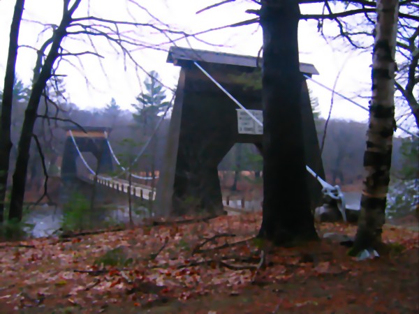
Coordinates: 44°55′0″N 70°4′16″W / 44.916667°N 70.07111°W Country United States State Maine County Somerset Area – Total 43.8 sq mi (113.4 km2) – Land 43.4 sq mi (112.5 km2) – Water 0.3 sq mi (0.9 km2) Elevation 449 ft (137 m) Population (2000) – Total 785 – Density 18.1/sq mi (7.0/km2) Time zone Eastern (EST) (UTC-5) – Summer (DST) EDT (UTC-4) ZIP codes 04954, 04961 Area code(s) 207 FIPS code 23-49205 GNIS feature ID 0582622 New Portland is a scenic town in Somerset County, Maine, United States nestled among some of the foothills, and within sight, of the Appalachian Mountains. It is perhaps best known for its Wire Bridge, a cable suspension bridge completed in 1866 that is the last remaining bridge of its type in Maine, and possibly the U.S. Much of North New Portland's Main Street burned to the ground in the fire of 1919, including a hotel. The annual town fair draws large crowds from around, and is held in September. The population was 785 at the 2000 census. The town was given to the residents of Falmouth (now Portland, Maine) by the Massachusetts legislature to repay them for their loss when the British fleet burned Falmouth in 1775.[1]
Contents
Geography
According to the United States Census Bureau, the town has a total area of 43.8 square miles (113 km2), of which, 43.4 square miles (112 km2) of it is land and 0.3 square miles (0.78 km2) of it (0.80%) is water. The town is situated on Route 27 adjacent to Kingfield and a short drive to the popular Sugarloaf ski resort. The scenic Carrabassett River flows through the West New Portland village and East New Portland village, whereas the Gilman Stream flows through the North New Portland village. The Carrabassett River is rocky and in places swift, whereas Gilman Stream is a slower river, amenable to kayaking and canoeing.
Demographics
As of the census[2] of 2000, there were 785 people, 329 households, and 227 families residing in the town. The population density was 18.1 people per square mile (7.0/km²). There were 564 housing units at an average density of 13.0 per square mile (5.0/km²). The racial makeup of the town was 98.34% White, 1.27% Native American, 0.13% from other races, and 0.25% from two or more races. Hispanic or Latino of any race were 0.38% of the population.
There were 329 households out of which 29.5% had children under the age of 18 living with them, 58.4% were married couples living together, 7.0% had a female householder with no husband present, and 30.7% were non-families. 23.7% of all households were made up of individuals and 10.0% had someone living alone who was 65 years of age or older. The average household size was 2.39 and the average family size was 2.77.
In the town the population was spread out with 22.7% under the age of 18, 5.7% from 18 to 24, 26.8% from 25 to 44, 29.4% from 45 to 64, and 15.4% who were 65 years of age or older. The median age was 42 years. For every 100 females there were 101.3 males. For every 100 females age 18 and over, there were 96.4 males.
The median income for a household in the town was $30,521, and the median income for a family was $35,284. Males had a median income of $26,354 versus $17,014 for females. The per capita income for the town was $14,596. About 8.3% of families and 11.6% of the population were below the poverty line, including 22.2% of those under age 18 and 2.3% of those age 65 or over.
Notable people
- Abram P. Williams, teacher, businessman, senator from California.
References
- ^ Maine League of Historical Societies and Museums (1970). Doris A. Isaacson. ed. Maine: A Guide 'Down East'. Rockland, Me: Courier-Gazette, Inc.. pp. 385.
- ^ "American FactFinder". United States Census Bureau. http://factfinder.census.gov. Retrieved 2008-01-31.
External links
Municipalities and communities of Somerset County, Maine Towns 
Plantations Unorganized
territoriesCDPs Anson | Bingham | Fairfield | Hartland | Madison | Norridgewock | Pittsfield | Skowhegan
Other
villagesFlagstaff | North Anson | Rockwood
Coordinates: 44°53′03″N 70°05′48″W / 44.88417°N 70.09667°W
Categories:- Towns in Somerset County, Maine


Wikimedia Foundation. 2010.