- Northeast Somerset, Maine
-
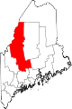
Northeast Somerset is an unorganized territory in Somerset County, Maine, United States. The population was 354 at the 2000 census.
Contents
Geography
According to the United States Census Bureau, the unorganized territory has a total area of 1,349.5 km² (521.0 mi²). 1,256.9 km² (485.3 mi²) of it is land and 92.6 km² (35.8 mi²) of it (6.86%) is water.
Townships
The territory consists of 14 townships plus three townships shared with Seboomook Lake and two townships shared with Northwest Somerset.
17 townships can be listed as follows:[1]
- Mayfield
- Bald Mountain
- East Moxie
- Square Town
- Moxie Gore
- Indian Stream EKR
- Chase Stream WKR
- Johnson Mountain
- Parlin Pond
- Misery Township
- Sapling
- Long Pond
- Sandwich Academy Grant
- Taunton & Raynham Academy Grant
- Rockwood Strip (T1 R1)
- Rockwood Strip (T2 R2)
- Misery Gore
Demographics
As of the census[2] of 2000, there were 354 people, 165 households, and 99 families residing in the unorganized territory. The population density was 0.3/km² (0.7/mi²). There were 1,062 housing units at an average density of 0.8/km² (2.2/mi²). The racial makeup of the unorganized territory was 96.61% White, 2.82% Native American, and 0.56% from two or more races. Hispanic or Latino of any race were 0.28% of the population.
There were 165 households out of which 23.6% had children under the age of 18 living with them, 52.1% were married couples living together, 4.2% had a female householder with no husband present, and 39.4% were non-families. 31.5% of all households were made up of individuals and 12.1% had someone living alone who was 65 years of age or older. The average household size was 2.15 and the average family size was 2.64.
In the unorganized territory the population was spread out with 21.5% under the age of 18, 2.3% from 18 to 24, 29.4% from 25 to 44, 33.1% from 45 to 64, and 13.8% who were 65 years of age or older. The median age was 44 years. For every 100 females there were 119.9 males. For every 100 females age 18 and over, there were 109.0 males.
The median income for a household in the unorganized territory was $20,917, and the median income for a family was $31,250. Males had a median income of $26,806 versus $17,750 for females. The per capita income for the unorganized territory was $14,520. About 22.1% of families and 22.1% of the population were below the poverty line, including 22.7% of those under age 18 and 19.0% of those age 65 or over.
References
Municipalities and communities of Somerset County, Maine Towns Anson | Athens | Bingham | Cambridge | Canaan | Caratunk | Cornville | Detroit | Embden | Fairfield | Harmony | Hartland | Jackman | Madison | Mercer | Moose River | Moscow | New Portland | Norridgewock | Palmyra | Pittsfield | Ripley | St. Albans | Skowhegan | Smithfield | Solon | Starks
Plantations Unorganized
territoriesCentral Somerset | Northeast Somerset | Northwest Somerset | Seboomook Lake
CDPs Anson | Bingham | Fairfield | Hartland | Madison | Norridgewock | Pittsfield | Skowhegan
Other
villagesFlagstaff | North Anson | Rockwood
Coordinates: 45°29′28″N 69°52′19″W / 45.49111°N 69.87194°W
Categories:- Unorganized territories in Maine
- Populated places in Somerset County, Maine

Wikimedia Foundation. 2010.