- Cobb Seamount
-
Cobb Seamount Map
Bathymetry of the seamountSummit depth 34 m (112 ft)[1] Height 2,743 m (8,999 ft)[2] Summit area 824 km2 (318 sq mi)[2] Location Coordinates 46°44′N 130°47′W / 46.733°N 130.783°WCoordinates: 46°44′N 130°47′W / 46.733°N 130.783°W Geology Type Seamount (underwater volcano), guyot Volcanic arc/chain Cobb-Eickelberg Seamount chain Age of rock 27±6 million[2] Last eruption Oligocene[2] History Discovered by MV John N. Cobb, 1950[2] Cobb Seamount is a seamount (underwater volcano) and guyot located 500 km (310 mi) west of Gray's Harbor, Washington, United States.[2] Cobb Seamount is one of the seamounts in the Cobb-Eickelberg Seamount chain, a chain of underwater volcanoes created by the Cobb hotspot that terminates near the coast of Alaska. It is aligned along the Cascadia subduction zone,[1] and was discovered in 1950 by edit] Geology
Cobb Seamount lies 270 mi (430 km) off the coast of Washington, in the 8,500 ft (2,600 m)-deep Cascadia Basin.[3] Potassium-argon dating of basalts retrieved from the volcano show that it is 27 ± 6 million years in age. Cobb Seamount's slopes average 12° in grade, and are indented by four prominent terraces at various depths; this unique morphology suggests that it was formed in the Oligocene period, and was then terraced over time by wave erosion.[2] Cobb Seamount's summit itself sits atop a 100 m (328 ft) deep terrace. The volcano's pinnacle is generally flat, and is defined by a pocketed area approximately 880 m (2,887 ft) by 577 m (1,893 ft) in size.[1]
Biology
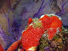 Red encrusting demosponge of the type found on Cobb Seamount.
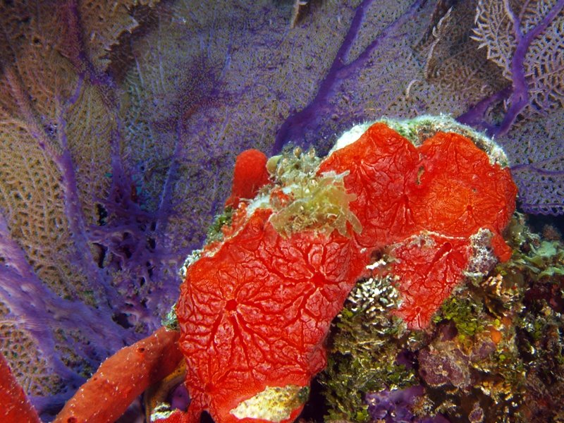
Although it is one of over 100 underwater features in the region, Cobb Seamount is the only one known to extend well upwards into the region of the ocean penetrated by light. Like many other seamounts, Cobb Seamount is a local biological hotspot and functions as an "island of stability" for local organisms. It supports an extensive fish population, mostly Sebastes species and especially Sebastes miniatus. Bird life has been noted in the area of its summit, indicating that it is a prime fishing ground.[3]
The summit of the volcano is dominated by a carpet of Hinnites multirugosus, which forms the base of a dense ecosystem of sponges and other small, sessile organisms. The species is otherwise scarce in its distribution in the Pacific; its abundance is accommodated by the scarcity of its chief predator, the Sea Star Orthasterias koehleri. The reason for the sea star's disparity is unknown, as it is extremely common on nearby seamounts.[1]
The steeper flanks of the volcanoes are carpeted by coralline algae of the Lithothamnion and Lithophyllum geneses. In some areas, Borgiola pustulosa is more common. Red-colored colonies of demosponge and related species predominant the ecosystem, which includes sea urchins, sponges, algae, anemones, and gastropods. While overall the species diversity on the seamount is lower than a comparable area on the surface, the species present have grown in greater numbers and have formed larger colonies, to the point that there was little to no bare rock surface on the seamount, and none has been found in expeditionary dives. Some endemism to the seamount has also been noted.[1]
The seamount's abundant sea life has made it a target for heavy fishing since the 1960s. However, the fishing is very difficult to monitor, since Cobb lies outside of the U.S. Exclusive Economic Zone and therefore fishing vessels are not regulated. It is known that it has been the site of trawling, gill net, and longline fishing for some time, mostly by the Japanese and Oregonian fleets. In 1993, the National Oceanic and Atmospheric Administration sponsored a study on the seamount, which concluded that concerns as to overfishing at the seamount have some merit. The study also notes that fishermen there have different fishing patterns, because of different physical conditions at the seamount.[4]
Expeditions
Since its discovery in 1950 by the RV Oceanographer, visited the seamount, and much of what was initially known about it stems from the expedition.[5] This was followed in 1970,[4] two expeditions in the late 1970s,[6] and 1992, however all have been fairly limited in scope.[4]
There was tentative expert interest in installing an experimentation platform on Cobb Seamount. The seamount is an accessible distance away from the shore, and would give scientists the ability to work with Cobb Seamount's unique, isolated, and scientifically significant seamount biology. The idea was proposed by P. L. Peterson et al. in a presentation to the Offshore Technology Conference in 1969.[1][3]
References
- ^ a b c d e f Birkeland, Charles (17 March 1971). "Biological Observations on Cobb Seamount". Northwest Science. http://www.vetmed.wsu.edu/org_nws/NWSci%20journal%20articles/1970-1978/1971%20vol%2045/vol%2045%20no%203/v45%20pg193%20Birkeland.PDF. Retrieved 20 October 2010.
- ^ a b c d e f g h "Cobb Seamount". University of California, Berkeley. [1967]. http://bioeng.berkeley.edu/budinger/cobbseamount.html. Retrieved 20 October 2010.
- ^ a b c Peterson, P. L.; et. al. (1969). "Structural Design of an Instrumented Mast to be Emplaced on Cobb Seamount in the Northeastern Pacific Ocean". Offshore Technology Conference. doi:10.4043/1060-MS. http://www.onepetro.org/mslib/servlet/onepetropreview?id=OTC-1060-MS&soc=OTC. Retrieved 11 November 2010.
- ^ a b c E Pearson, Donald; A. Douglas, David; Barss, Bill (1993). "Biological Observations from Cobb Seamount rockfish fishery". Fishery Bulliten (National Oceanic and Atmospheric Administration) 19 (3): 573–576. http://fishbull.noaa.gov/913/pearson.pdf. Retrieved 12 November 2010.
- ^ P. Spencer, Merrill; D. Campbell, Spencer; Carl, Eurick (May 1969). "Diving to Cobb Seamount: A Report on Diving Operations on Project Sea Use, Phase 1,1968". Journal of Occupational Medicine (Lippincott Williams & Wilkins) 11 (5): 285–291. http://journals.lww.com/joem/Citation/1969/05000/Diving_to_Cobb_Seamount__A_Report_on_Diving.17.aspx. Retrieved 11 November 2010.
- ^ Britt, Ian. "Deepsea cobb seamount" (Email correspondence). http://www.bio.net/bionet/mm/deepsea/2009-January/000697.html. Retrieved 12 November 2010.
Categories:- Hotspot volcanoes
- Submarine volcanoes
- Seamounts of the Cobb-Eickelberg Seamount chain
Wikimedia Foundation. 2010.