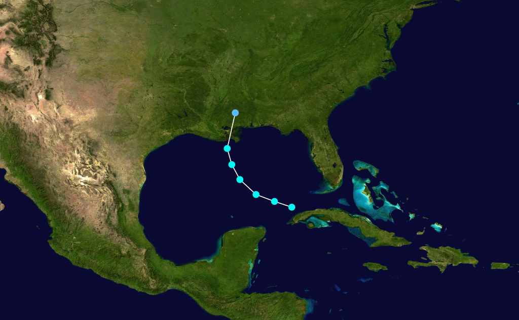
- 1936 Atlantic hurricane season
Infobox hurricane season | name=1936 Atlantic hurricane season
first storm formed=June 12 ,1936
last storm dissipated=October 11 ,1936
strongest storm=#13 - 120 mph (195 km/h) - 968 mbar
total storms=16
major storms=1
total daUSD )
$17.8 million (2006 USD)
total fatalities=5
basin=Atlantic hurricane
five seasons=1934, 1935, 1936, 1937, 1938 The 1936 Atlantic hurricane season officially began onJune 16 ,1936 , [Galveston Daily News . [http://www.thehurricanearchive.com/Viewer.aspx?] Retrieved on
2008-06-06 .] and lasted untilOctober 31 ,1936 . These dates conventionally delimit the period of each year when mosttropical cyclone s form in theAtlantic basin .The 1936 season was fairly active, with 17 tropical cyclones including a tropical depression. Seven became hurricanes, of which one became a major hurricane. Despite the activity, conditions were generally unfavorable throughout the season. In addition, the season was unusual in the fact that no storms moved across large portions of the
Caribbean Sea .cite web|author=I. R. Tannehill|year=1936|title=Tropical Disturbances of 1936|publisher=U.S. Weather Bureau|accessdate=2006-09-09|url=http://docs.lib.noaa.gov/rescue/mwr/064/mwr-064-12-0427.pdf] Seven storms, including three hurricanes, struck theUnited States . The season also set many records for the earliest date for a numbered storm, though all were surpassed by the extreme activity of the 2005 season.torms
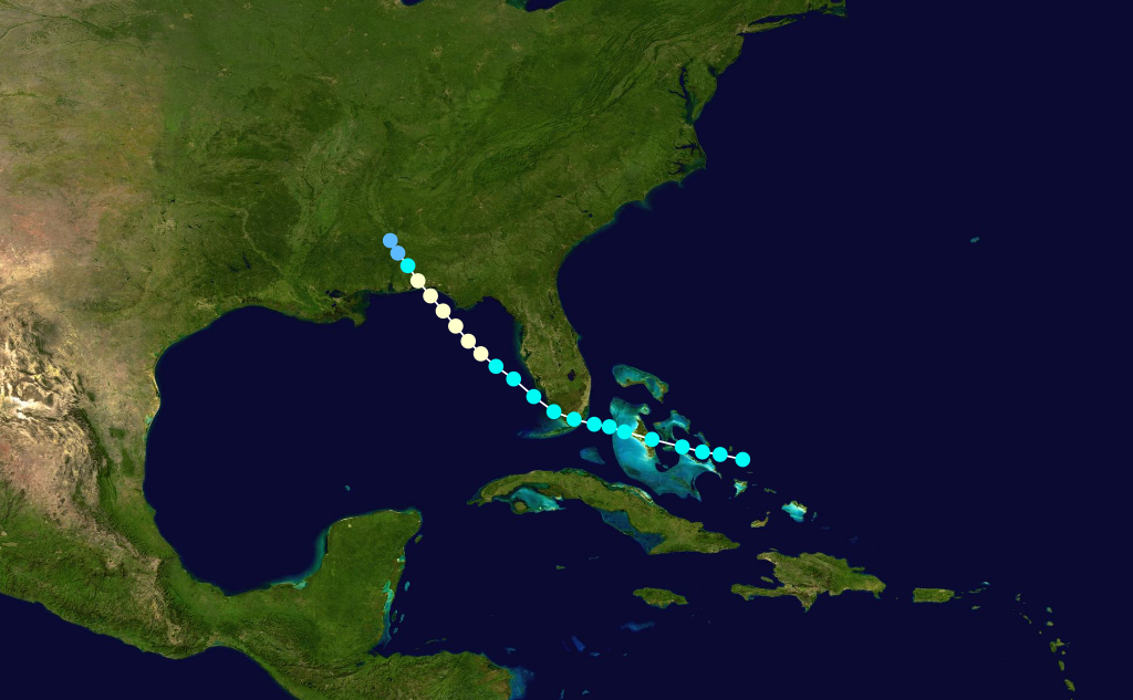
Tropical Storm One
infobox hurricane small
name=Tropical Storm One
category=storm
type=tropical storm

formed=June 12
dissipated=June 17 ,1936
highest winds=45 mph (75 km/h)
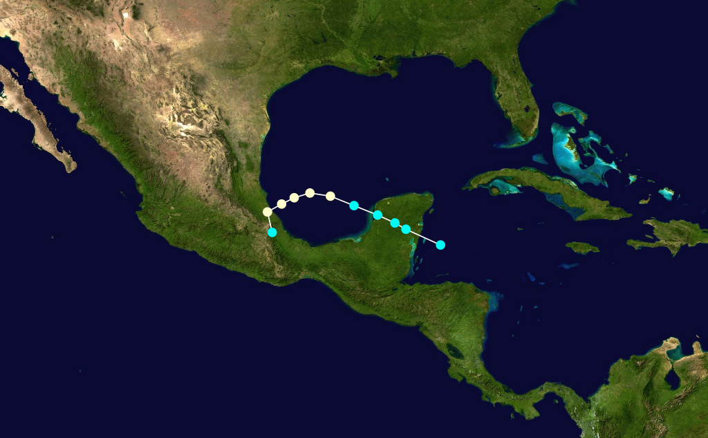
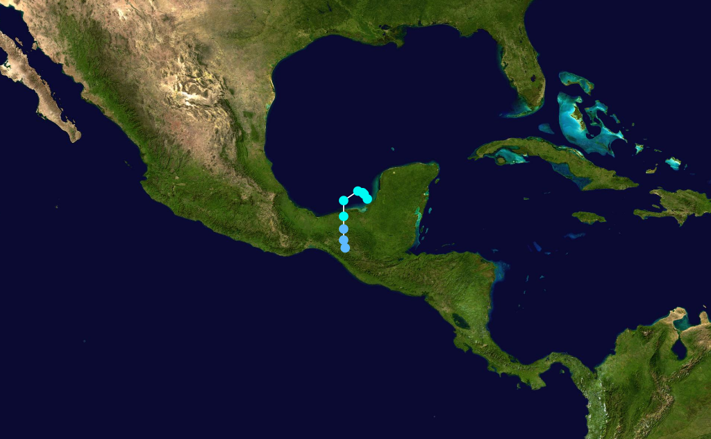
lowest pressure=998mbar OnJune 9 , a tropical storm made landfall on the Pacific coast ofGuatemala . It moved northeastward acrossCentral America , and entered the westernCaribbean Sea onJune 11 . The storm quickly re-organized, and again developed into a tropical storm onJune 12 . It moved north-northeastward, resulting in light winds as it paralleled the eastern coasts ofBelize and theYucatan Peninsula . After reaching theGulf of Mexico with peak winds of 45 mph (75 km/h), the storm turned to the northeast, then to the east. OnJune 15 , the tropical storm made landfall about 20 miles (32 km) to the south ofFort Myers, Florida , and after crossing the state it passed over Miami before entering theAtlantic Ocean . It weakened as it accelerated northeastward through theBahamas , and onJune 17 the system dissipated to the north ofBermuda .Cite web|author=I. R. Tannehill|year=1936|title=Tropical Disturbances of 1936|publisher=Weather Bureau|accessdate=2006-09-09|url=http://www.aoml.noaa.gov/general/lib/lib1/nhclib/mwreviews/1936.pdf]While crossing Central America, the storm produced heavy rainfall. In southern
Florida , winds from the storm ranged from 30 mph (48 km/h) to a peak of 39 mph (63 km/h) in Miami. The storm produced heavy rainfall in southern Florida, ranging from 8 to 15 inches (200 to 380 mm). The rainfall caused flooding of highways and lowlands, drowned several livestock, and some damage. The storm caused three indirect deaths when a Coast Guard airplane crashed inTampa Bay while in search of small boats.Tropical Storm Two
infobox hurricane small
name=Tropical Storm Two
category=storm
type=tropical storm
formed=June 19
dissipated=June 22 ,1936
highest winds=40 mph (70 km/h)
lowest pressure=1004mbar An area of disturbed weather was first detected near theYucatan Peninsula onJune 18 . It tracked west-northwestward, and developed into a tropical storm the following day. The storm continued to the west-northwest untilJune 21 , when the storm turned to the west-southwest. Having remained a minimal tropical storm for all of its lifetime, the 40-mph (70-km/h) storm struck northeastMexico on the 21st, and dissipated the next day. The storm caused higher than normal tides along theTexas coastline, and no damage or deaths were reported.Hurricane Three
infobox hurricane small
name=Hurricane Three
category=cat1
type=hurricane
formed=June 26
dissipated=June 28 ,1936
highest winds=80 mph (110 km/h)
lowest pressure=990mbar A small tropical storm developed onJune 26 while located 125 miles (200 km) east ofBrownsville, Texas . It moved northwestward and rapidly strengthened, attaining hurricane status with peak winds of 80 mph (110 km/h) by early onJune 27 . Later on the 27th, the hurricane made landfall near Port Aransas with a pressure of 990mbar . The storm rapidly weakened over land, and dissipated onJune 28 near San Antonio. A small craft warning was issued for the Corpus Christi area on the morning of the storm making landfall, and the National Weather Bureau issued a Hurricane Warning just 45 minutes prior to the hurricane striking land.Upon making landfall, the storm caused a 3.8-foot (1.2-m)
storm tide , and many small boats were capsized or driven ahore. The hurricane produced wind gusts of up to 90 mph (145 km/h) in Ingleside and up to 80 mph (110 km/h) in Port Aransas, destroying cooling towers at a local oil refinery and damaging a few houses. Along its path, the storm produced heavy rainfall, though specifics are unknown.Cite web|author=David Roth|year=2000|title=Texas Hurricane History|publisher=NOAA|accessdate=2006-09-10|url=http://www.srh.noaa.gov/lch/research/txerly20hur4.php] Severe crop damage was reported in San Patricio and Nueces Counties. In all, the hurricane caused $550,000 in damage (1936 USD, $8 million 2006 USD), primarily to oil refinery property, though no deaths or injuries were reported.Tropical Storm Four
infobox hurricane small
name=Tropical Storm Four
category=storm
type=tropical storm
formed=July 26
dissipated=July 27 ,1936
highest winds=45 mph (75 km/h)
lowest pressure=1007mbar OnJuly 26 , a small tropical storm formed near the western tip ofCuba from a tropical disturbance. It moved quickly northwestward, then turned northward, reaching a peak intensity of 45 mph (75 km/h). OnJuly 27 , the storm accelerated northeastward and made landfall on southeasternLouisiana with a pressure of 1003mbar . The storm rapidly weakened over land and dissipated late on the 27th. The Weather Bureau office issued a storm warning for the Louisiana coastline, advising those potentially affected to prepare for strong winds and rising tides. However, the storm caused no serious damage, and no casualties are associated with the storm.Hurricane Five
infobox hurricane small
name=Hurricane Five
category=cat1
type=hurricane
formed=July 27
dissipated=August 1 ,1936
highest winds=90 mph (145 km/h)
lowest pressure=973mbar A tropical storm was first observed over the southernBahamas onJuly 27 . It tracked to the west-northwest, and made landfall a short distance south ofEverglades City, Florida with winds of 60 mph (95 km/h). After crossing the state, it intensified over the easternGulf of Mexico and became a hurricane onJuly 30 . The hurricane continued to strengthen, and hit the westernFlorida Panhandle with peak winds of 90 mph (145 km/h) onJuly 31 . It weakened rapidly over land, and dissipated over westernAlabama onAugust 1 .In south Florida, the storm caused a storm tide of 5.5 feet (1.7 m) when it made landfall, causing flooding of up to 1.5 feet (0.5 m) in coastal areas. Though winds reached 60 mph (95 km/h), damage was minimal there. In Valparaiso in the Florida Panhandle, the hurricane produced wind gusts of up to 100 mph (160 km/h), along with a storm tide of 6 feet (1.8 m). Damage from the storm was relatively minor, totaling to $123,000 (1936 USD, $1.78 million 2006 USD). The hurricane indirectly killed four people when a boat capsized in the Gulf of Mexico.
Tropical Storm Six
infobox hurricane small
name=Tropical Storm Six
category=storm
type=tropical storm
formed=August 4
dissipated=August 10 ,1936
highest winds=45 mph (75 km/h)
pressure=UnknownThe sixth tropical storm of the season was first spotted onAugust 4 while located 155 miles (250 km) east-northeast ofBarbuda . It tracked northwestward, and reached a peak intensity of 45 mph (75 km/h) onAugust 5 . On the 7th, it weakened to minimal storm status, which was followed by a turn to the northeast onAugust 8 . On the 9th, the storm passed 160 miles (260 km) to the west ofBermuda , and early onAugust 10 the storm became extratropical over the openAtlantic Ocean . The extratropical storm continued northeastward until dissipating late on the 10th while 280 miles (450 km) south of the eastern tip ofNova Scotia . The storm never affected land.cite web|author=Unisys Corporation|year=2006|title=1936 Atlantic hurricane season|accessdate=2006-09-12|url=http://www.weather.unisys.com/hurricane/atlantic/1936/index.html]Tropical Storm Seven
infobox hurricane small
name=Tropical Storm Seven
category=storm
type=tropical storm
formed=August 7
dissipated=August 12 ,1936
highest winds=40 mph (70 km/h)
lowest pressure=1012mbar A weaktropical storm formed onAugust 7 in the eastern Gulf of Mexico west-northwest of theDry Tortugas . The system moved northwest towards the northwestGulf of Mexico throughAugust 9 while maintaining its peak of 40 mph (65 km/h). The storm then began to curve more to the west-southwest onAugust 10 while located just south-southwest ofPort Eads, Louisiana while maintaining intensity. The storm continued moving southwest throughAugust 11 , weakening to a tropical depression shortly before making landfall nearTampico onAugust 12 . The system weakened quickly after moving inland, and dissipated shortly afterwards.Advisories were issued early on August 12 from the U.S. Weather Bureau in New Orleans for the system as it neared Mexico shortly before making landfall,cite web|author=The Chronicle-Telegram|year=1936|title="Hurricane Warning Issued To Mexico"|accessdate=2006-10-31|url=http://www.thehurricanearchive.com/Viewer.aspx?
] but little damage and no deaths were reported in Mexico.
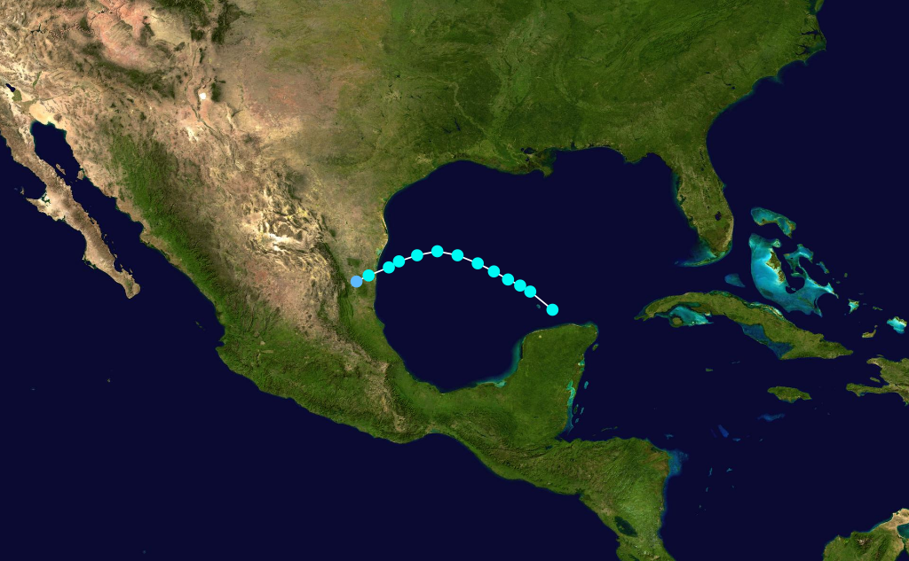
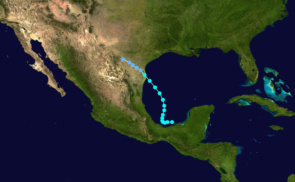
Hurricane Eight
infobox hurricane small
name=Hurricane Eight
category=cat1
type=hurricane
formed=August 15
dissipated=August 19 ,1936
highest winds=80 mph (130 km/h)
lowest pressure=999mbar A tropical disturbance was detected in the western to northwestCaribbean Sea nearCancún onAugust 15 . The system moved northwest into the southwestGulf of Mexico as a tropical storm onAugust 16 while slowly strengthening. The system reached hurricane intensity as a Category 1 onAugust 17 , and reached its peak of 80 mph (130 km/h) shortly afterwards. The hurricane began to move west-southwest late onAugust 17 and throughAugust 18 , eventually making landfall nearTampico onAugust 19 as a 75 mph (120 km/h) minimal hurricane. The system quickly weakened just after moving inland and dissipated on the same day.The hurricane brought heavy rains to mainland
Mexico , while the highest winds recorded at Tampico were 30 mph (50 km/h) on August 19 as the center passed nearby just to the north. Storm warnings were issued on August 17 and 18 as the system initially approached the upper Gulf Coast ofLouisiana andTexas , but the system's west-southwest turn prevented a directUnited States landfall.Tropical Storm Nine
infobox hurricane small
name=Tropical Storm Nine
category=storm
type=tropical storm
formed=August 20
dissipated=August 23 ,1936
highest winds=50 mph (80 km/h)
lowest pressure=1002mbar A weak tropical storm formed onAugust 20 near the eastern Bahamas. Moving slowly west-northwest throughAugust 21 , the system strengthened to its peak of 50 mph (80 km/h) later onAugust 21 , and made landfall onAugust 22 near Daytona Beach at its peak intensity. The system maintained tropical storm intensity inland while slowly weakening and moving westward, and the storm eventually weakened to a depression onAugust 23 while entering the easternFlorida Panhandle , and the system dissipated shortly afterwards near as it drifted over easternMississippi .

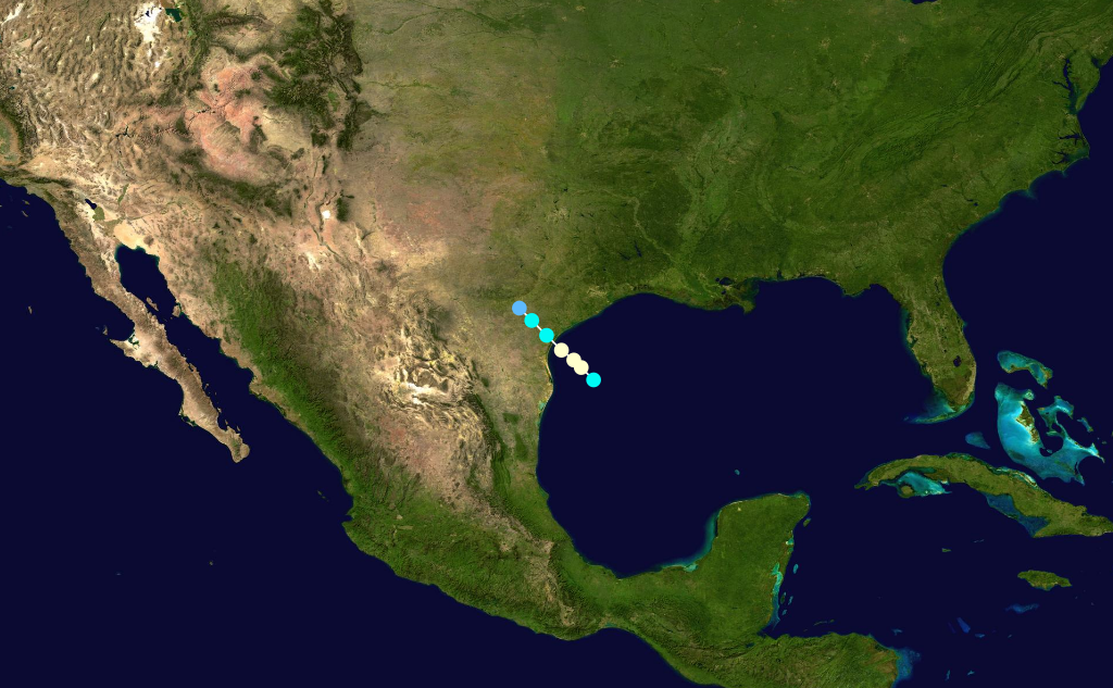
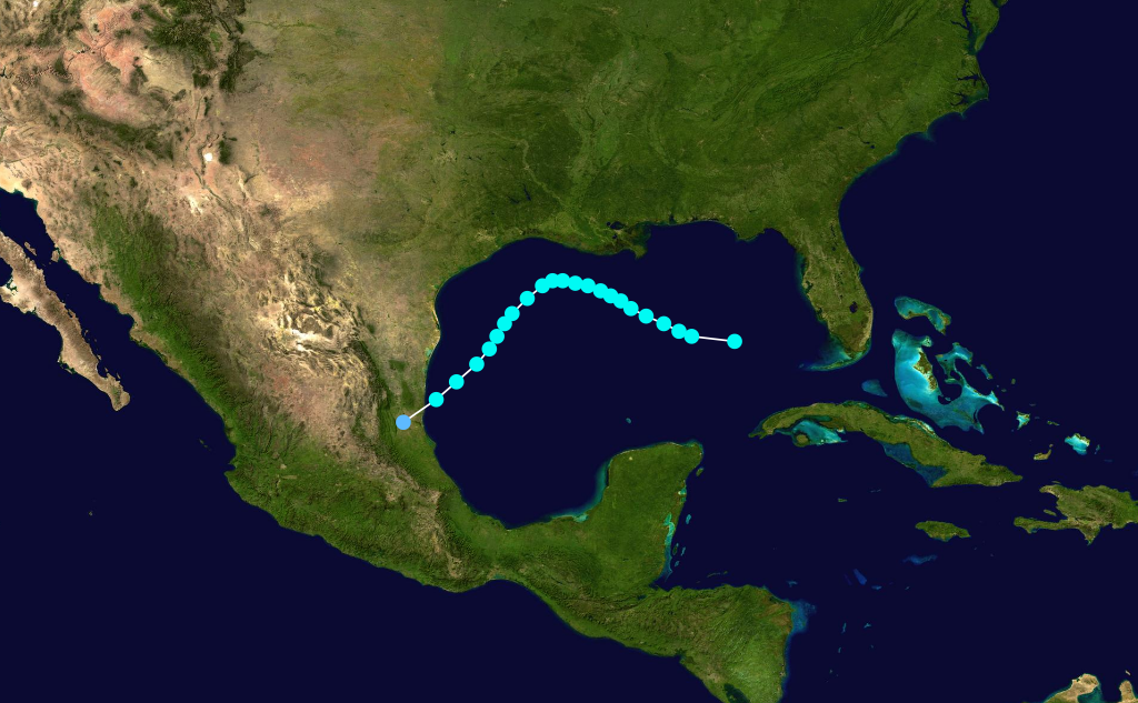
Hurricane Ten
infobox hurricane small
name=Hurricane Ten
category=cat1
type=hurricane
formed=
dissipated=
highest winds=80 mph (130 km/h)
lowest pressure=999
Although advisories were issued for Mexico on August 29 and early on August 30 from the U.S. Weather Bureau in New Orleans, little overall damage was reported in mainland Mexico.
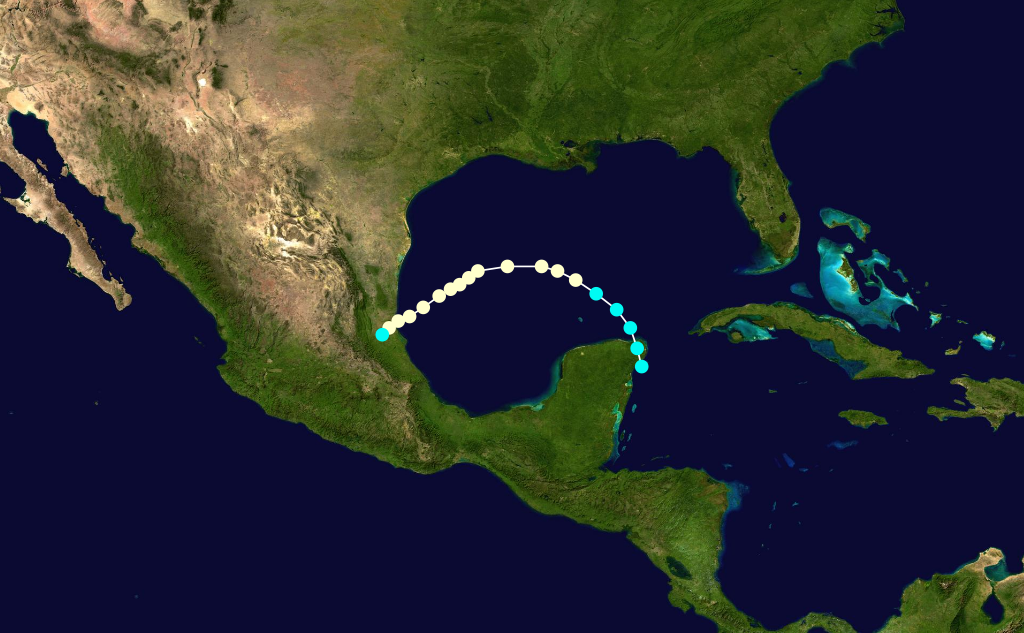
Hurricane Eleven
infobox hurricane small
name=Hurricane Eleven
category=cat2
type=hurricane
formed=
dissipated=
highest winds=110 mph (175 km/h)
lowest pressure=982
Tropical Storm Twelve
infobox hurricane small
name=Tropical Storm Twelve
category=storm
type=tropical storm
formed=
dissipated=
highest winds=40 mph (65 km/h)
lowest pressure=1008
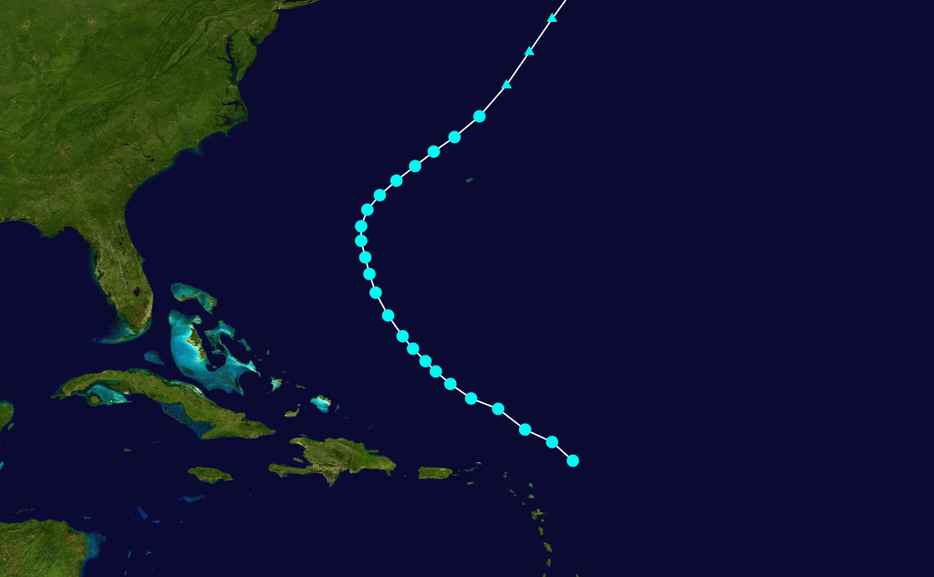
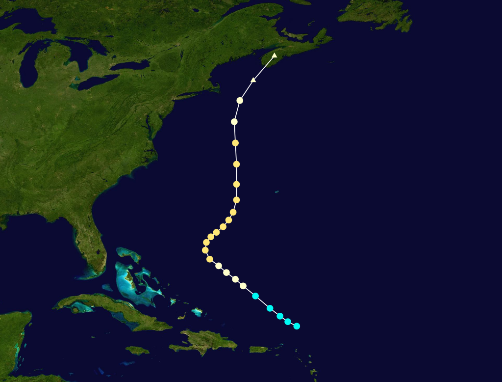
Hurricane Thirteen
infobox hurricane small
name=Hurricane Thirteen
category=cat3
type=hurricane
formed=
dissipated=
highest winds=120 mph (195 km/h)
lowest pressure=968
In Tropical Storm Fourteen infobox hurricane small Hurricane Fifteen infobox hurricane small Tropical Depression A tropical depression formed in the western Tropical Storm Sixteen infobox hurricane small Accumulated Cyclone Energy Rating (ACE) The table below shows the ACE for each storm in the season. Broadly speaking, the ACE is a measure of the power of the hurricane multiplied by the duration of its lifetime; thus, hurricanes that lasted a long time (such as Thirteen) have higher ACEs. Despite the high number of storms, most were relatively short-lived and weak, and the ACE only suggested a near-normal season. The ACE rating is only calculated for full advisories on tropical systems at or exceeding 35 knots (39 mph/63 km/h) or tropical storm strength. ee also * References External links * [http://www.aoml.noaa.gov/general/lib/lib1/nhclib/mwreviews/1936.pdf 1936 Monthly Weather Review]
Wikimedia Foundation.
2010.
name=Tropical Storm Fourteen
category=storm
type=tropical storm
formed=
dissipated=
highest winds=45 mph (70 km/h)
lowest pressure=1008
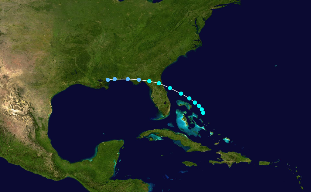
name=Hurricane Fifteen
category=cat2
type=hurricane
formed=
dissipated=
highest winds=110 mph (140 km/h)
lowest pressure=977
name=Tropical Storm Sixteen
category=storm
type=tropical storm
formed=
dissipated=
highest winds=40 mph (70 km/h)
lowest pressure=1006
*