- 1935 Atlantic hurricane season
Infobox hurricane season | name=1935 Atlantic hurricane season
first storm formed=Aug. 18, 1935
last storm dissipated=Nov. 8, 1935
strongest storm=Labor Day Hurricane - 140 knots (160 mph) (unofficial est.)cite web|author=David A. Glenn|year=2005|title=A Reanalysis of the 1916, 1918, 1927, 1928, and 1935 Tropical Cyclones of the North Atlantic Basin|publisher=NOAA|accessdate=2007-05-09|url=http://www.aoml.noaa.gov/hrd/hurdat/GlennThesis.pdf]
total storms=6
major storms=3
total da
total fatalities=2,604
basin=Atlantic hurricane
five seasons=1933, 1934, 1935, 1936, 1937 The 1935 Atlantic hurricane season ran through the summer and the first half of fall in 1935. The 1935 season featured below average activity, but it was extremely eventful. A Category 1 hurricane in theCaribbean killed an estimated 2,150 people in theGreater Antilles andCentral America . A Category 4 storm hit centralCuba and grazed Miami. An extratropical hurricane hit Newfoundland. The second tropical cyclone of the season struck theFlorida Keys in southern Florida as a Category 5 hurricane; it remains the strongest landfalling hurricane in the United States (and anywhere in the Atlantic basin).cite web|author=Blake, Rappaport, and Landsea|year=2006|title=The Deadliest, Costliest, and Most Intense United States Tropical Cyclones (1851 to 2006)|publisher=NOAA|accessdate=2008-01-08|url=http://www.nhc.noaa.gov/pdf/NWS-TPC-5.pdf] A rare November hurricane also affected the Miami—Fort Lauderdale area.__TOC__
torms
Hurricane One
infobox hurricane small
name=Hurricane One
category=cat3
type=hurricane
formed=August 18
dissipated=August 26
highest winds=120 mph (195 km/h)
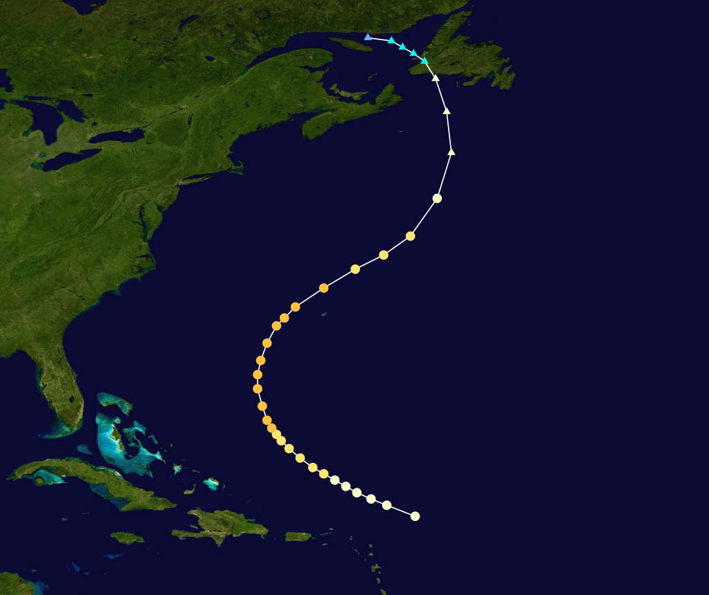
lowest pressure=<954 mbarcite web|author=David A. Glenn|year=2005|title=A Reanalysis of the 1916, 1918, 1927, 1928, and 1935 Tropical Cyclones of the North Atlantic Basin|publisher=NOAA|accessdate=2007-05-09|url=http://www.aoml.noaa.gov/hrd/hurdat/GlennThesis.pdf] A hurricane was detected near the Leeward Islands on August 18. Moving west-northwest, the storm gradually intensified into a Category 2 hurricane the following day. On August 20, the system began to curve northward and later north-northeast, and the hurricane reached its peak of 120 mph (195 km/h) on August 22. The hurricane later passed just west ofBermuda late on August 22 as a slightly weaker 115 mph (185 km/h) hurricane. On August 24, the hurricane weakened to a Category 2 hurricane and began to turn more to the north. Continuing to curve northwestward on August 25, the hurricane continued to weaken to a Category 1 hurricane, later striking Newfoundland as an extratropical storm on August 26. The storm later dissipated on the same day.Hurricane Two
infobox hurricane small
name=Hurricane Two
category=cat5
type=hurricane
formed=August 29
dissipated=September 10
highest winds=185 mph (300 km/h)cite web|author=David A. Glenn|year=2005|title=A Reanalysis of the 1916, 1918, 1927, 1928, and 1935 Tropical Cyclones of the North Atlantic Basin|publisher=NOAA|accessdate=2007-05-09|url=http://www.aoml.noaa.gov/hrd/hurdat/GlennThesis.pdf]
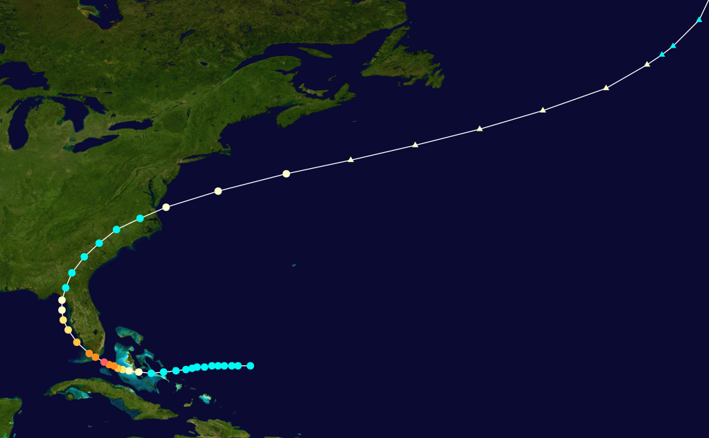
lowest pressure=892 mbarBy far the most notable storm of the season was the Labor Day Hurricane that made landfall in theFlorida Keys on September 2. The storm was first detected as a disturbance east of theBahamas . It strengthened very rapidly as it moved across theStraits of Florida . It made landfall onCraig Key in the Upper Keys as a small but intense Category 5 major hurricane. A pressure reading of 892 millibars (26.35 inHg) was recorded near where the center crossed the islands. The pressure reading makes the Labor Day Hurricane the most intense to ever strike the U.S. It ranks third on the list of the most intense Atlantic hurricanes based on lowest pressure, behind onlyHurricane Gilbert of 1988, which did not strike the U.S., and Wilma of 2005.After crossing the Keys, the storm proceeded up the
Florida west coast, bringing flooding rains all along the way. The storm made its final landfall on the sparsely-populated Apalachee coast near Cedar Key on September 5. It moved inland and then curved back out to sea and later dissipated in the North Atlantic on September 10. More than 400 people were killed in the Keys and the damage in the area of landfall was catastrophic. Portions of theFlorida East Coast Railway in the Upper Keys were severely damaged or destroyed. The hurricane also washed an evacuation train off the tracks and many who were awaiting rescue, includingWorld War I veterans who were living and working in the Keys as part of a government relief project, were killed.Tropical Storm Three
infobox hurricane small
name=Tropical Storm Three
category=storm
type=tropical storm
formed=August 30
dissipated=September 1
highest winds=40 mph (65 km/h)cite web|author=David A. Glenn|year=2005|title=A Reanalysis of the 1916, 1918, 1927, 1928, and 1935 Tropical Cyclones of the North Atlantic Basin|publisher=NOAA|accessdate=2007-05-09|url=http://www.aoml.noaa.gov/hrd/hurdat/GlennThesis.pdf]
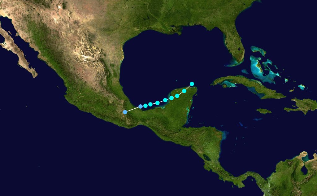
pressure=UnknownA short-lived weak tropical storm formed west of theYucatán Peninsula on August 31.cite web|author=David A. Glenn|year=2005|title=A Reanalysis of the 1916, 1918, 1927, 1928, and 1935 Tropical Cyclones of the North Atlantic Basin|publisher=NOAA|accessdate=2007-05-09|url=http://www.aoml.noaa.gov/hrd/hurdat/GlennThesis.pdf] The tropical cyclone strengthened to its peak with winds of 40 mph (65 km/h) over theBay of Campeche .cite web|author=David A. Glenn|year=2005|title=A Reanalysis of the 1916, 1918, 1927, 1928, and 1935 Tropical Cyclones of the North Atlantic Basin|publisher=NOAA|accessdate=2007-05-09|url=http://www.aoml.noaa.gov/hrd/hurdat/GlennThesis.pdf] The system eventually weakened to a depression on September 1 shortly before making landfall in mainland Mexico. The system weakened after moving inland and dissipated later on the same day.Hurricane Four
infobox hurricane small
name=Hurricane Four
category=cat4
type=hurricane
formed=September 23
dissipated=October 2
highest winds=135 mph (215 km/h)cite web|author=David A. Glenn|year=2005|title=A Reanalysis of the 1916, 1918, 1927, 1928, and 1935 Tropical Cyclones of the North Atlantic Basin|publisher=NOAA|accessdate=2007-05-09|url=http://www.aoml.noaa.gov/hrd/hurdat/GlennThesis.pdf]
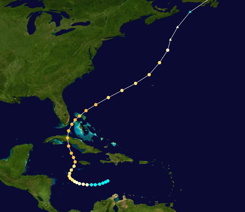
lowest pressure=≤945 mbarA tropical storm formed in the westernCaribbean Sea south-southeast ofJamaica on September 23. Moving westward, the system strengthened into a hurricane on September 24 and later a Category 2 hurricane on September 26 while beginning to curve northward. The hurricane continued to strengthen while slowly moving northward, strengthening to its first peak of 115 mph (185 km/h) as a major hurricane on September 27.cite web|author=David A. Glenn|year=2005|title=A Reanalysis of the 1916, 1918, 1927, 1928, and 1935 Tropical Cyclones of the North Atlantic Basin|publisher=NOAA|accessdate=2007-05-09|url=http://www.aoml.noaa.gov/hrd/hurdat/GlennThesis.pdf] The hurricane struck Cuba shortly thereafter, and it entered theStraits of Florida as a Category 2 hurricane on September 29.cite web|author=David A. Glenn|year=2005|title=A Reanalysis of the 1916, 1918, 1927, 1928, and 1935 Tropical Cyclones of the North Atlantic Basin|publisher=NOAA|accessdate=2007-05-09|url=http://www.aoml.noaa.gov/hrd/hurdat/GlennThesis.pdf] While beginning to turn northeast, the hurricane intensified. It passed over the Bahamas shortly thereafter as a 135 mph (215 km/h) Category 4 hurricane, eventually weakening to a Category 2 hurricane on September 30 while accelerating away from the United States mainland. The hurricane passed near Bermuda on October 1, later weakening to a Category 1 hurricane and becoming extratropical the following day. The storm caused great destruction across Cuba and the Bahamas, killing 50 people (mostly in floods).Bimini was swamped by a 15 foot storm surge that destroyed most of the buildings on the island, and winds were estimated near 120 mph (195 km/h).cite web|url=http://www.aoml.noaa.gov/hrd/hurdat/mwr_pdf/1935.pdf|title=1935 Monthly Weather Review|publisher=U.S. Weather Bureau|accessdate=2007-01-07]Hurricane Five
infobox hurricane small
name=Hurricane Five
category=cat1
type=hurricane
formed=October 19
dissipated=October 27
highest winds=85 mph (135 km/h)
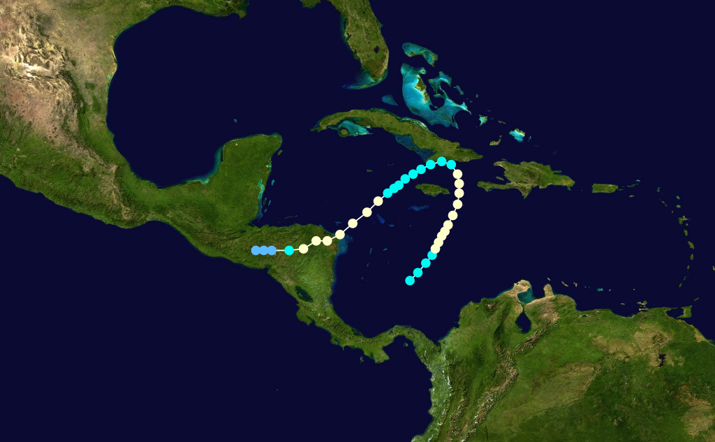
lowest pressure=988 mbarA tropical storm formed late in the season on October 18 in the south-centralCaribbean Sea with winds of 40 mph (65 km/h).cite web|author=David A. Glenn|year=2005|title=A Reanalysis of the 1916, 1918, 1927, 1928, and 1935 Tropical Cyclones of the North Atlantic Basin|publisher=NOAA|accessdate=2007-05-09|url=http://www.aoml.noaa.gov/hrd/hurdat/GlennThesis.pdf] Moving slowly north-northeast, the system strengthened quickly into a hurricane on October 20, and it attained its first peak intensity of 85 mph (135 km/h) just south-southeast of Kingston.cite web|author=David A. Glenn|year=2005|title=A Reanalysis of the 1916, 1918, 1927, 1928, and 1935 Tropical Cyclones of the North Atlantic Basin|publisher=NOAA|accessdate=2007-05-09|url=http://www.aoml.noaa.gov/hrd/hurdat/GlennThesis.pdf] The hurricane slowed on October 22 just east of Jamaica. Later, the hurricane made landfall nearSantiago de Cuba early on October 23.cite web|author=David A. Glenn|year=2005|title=A Reanalysis of the 1916, 1918, 1927, 1928, and 1935 Tropical Cyclones of the North Atlantic Basin|publisher=NOAA|accessdate=2007-05-09|url=http://www.aoml.noaa.gov/hrd/hurdat/GlennThesis.pdf] Continuing to turn southwest on October 23, the system weakened to a 60 mph (95 km/h) tropical storm in the western Caribbean. The system began to reintensify shortly thereafter, regaining hurricane status late on October 24 and regaining a second peak intensity of 65 mph (105 km/h) on October 25. On October 26, it made landfall inNicaragua as a Category 1 hurricane.cite web|author=David A. Glenn|year=2005|title=A Reanalysis of the 1916, 1918, 1927, 1928, and 1935 Tropical Cyclones of the North Atlantic Basin|publisher=NOAA|accessdate=2007-05-09|url=http://www.aoml.noaa.gov/hrd/hurdat/GlennThesis.pdf] The hurricane maintained intensity after moving inland before weakening to a tropical storm on October 26, eventually weakening to a tropical depression on October 27 over interiorCentral America . The system dissipated shortly thereafter. This storm caused catastrophic flooding that killed roughly 2,150 people in Haiti and Central America and caused upwards of $2 million in damages (1935 dollars).cite web|url=http://www.aoml.noaa.gov/hrd/hurdat/mwr_pdf/1935.pdf|title=1935 Monthly Weather Review|publisher=U.S. Weather Bureau|accessdate=2007-01-07]Hurricane Six
infobox hurricane small
name=Hurricane Six
category=cat2
type=hurricane
formed=October 30
dissipated=November 8
highest winds=105 mph (165 km/h)cite web|author=David A. Glenn|year=2005|title=A Reanalysis of the 1916, 1918, 1927, 1928, and 1935 Tropical Cyclones of the North Atlantic Basin|publisher=NOAA|accessdate=2007-05-09|url=http://www.aoml.noaa.gov/hrd/hurdat/GlennThesis.pdf]
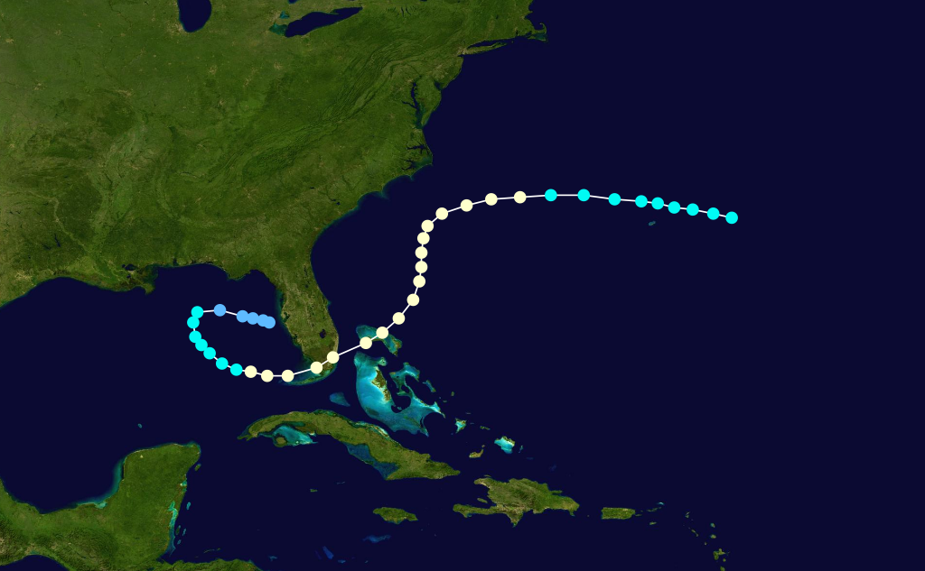
lowest pressure=964 mbarA rare early November hurricane strike in the Miami area, this storm began as a tropical storm near Bermuda on October 30. Moving westward, the storm strengthened to a 75 mph (120 km/h) Category 1 hurricane on November 1 while initially threatening theNorth Carolina coastline. The system began to turn southwest on November 2, however, while continuing to strengthen to its peak of 105 mph (120 km/h), while a ship recorded a minimal pressure of 964 mbar.cite web|author=David A. Glenn|year=2005|title=A Reanalysis of the 1916, 1918, 1927, 1928, and 1935 Tropical Cyclones of the North Atlantic Basin|publisher=NOAA|accessdate=2007-05-09|url=http://www.aoml.noaa.gov/hrd/hurdat/GlennThesis.pdf] The hurricane continued moving slowly south-southwest, eventually making landfall near Miami Beach as a Category 2 hurricane on November 4 with a measured pressure of 973 mbar at landfall.cite web|author=David A. Glenn|year=2005|title=A Reanalysis of the 1916, 1918, 1927, 1928, and 1935 Tropical Cyclones of the North Atlantic Basin|publisher=NOAA|accessdate=2007-05-09|url=http://www.aoml.noaa.gov/hrd/hurdat/GlennThesis.pdf] The system crossed the southern end of the Florida peninsula shortly thereafter, eventually entering the southeastGulf of Mexico as a minimal hurricane near theDry Tortugas on November 5. The hurricane then weakened into a tropical storm while beginning a slow clockwise loop in the eastern Gulf, eventually curving back east while weakening to a depression just west of Saint Petersburg late on November 7. The system dissipated just offshore on November 8. It had killed 19 people and caused upwards of $5.5 million in uninflated damage.cite web|url=http://www.aoml.noaa.gov/hrd/hurdat/mwr_pdf/1935.pdf|title=1935 Monthly Weather Review|publisher=U.S. Weather Bureau|accessdate=2007-01-07] The hurricane's unusual approach toward Florida and late arrival earned it the nickname of the Yankee Hurricane.cite web|author=Douglas, Marjory Stoneman|year=1958|url=http://www.keyshistory.org/35-hurr-Douglas.html|title=The Florida Keys, 1935|publisher=Rinehart and Company|accessdate=2007-01-07]ee also
*
List of tropical cyclones
*List of Atlantic hurricane seasons References
External links
* [http://www.aoml.noaa.gov/general/lib/lib1/nhclib/mwreviews/1935.pdf Monthly Weather Review]
)
Wikimedia Foundation. 2010.