- Codsall
-
Coordinates: 52°37′36″N 2°11′33″W / 52.62671°N 2.19237°W
Codsall 
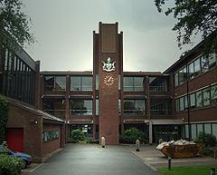
The District Council Offices
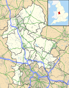
 Codsall shown within Staffordshire
OS grid reference SJ870032 District South Staffordshire Shire county Staffordshire Region West Midlands Country England Sovereign state United Kingdom Post town Wolverhampton Postcode district WV8 Dialling code 01902 Police Staffordshire Fire Staffordshire Ambulance West Midlands EU Parliament West Midlands List of places: UK • England • Staffordshire Codsall is a large village in the South Staffordshire district of Staffordshire, England. It is situated north west of the city of Wolverhampton.
Contents
History
In 1086, the Domesday Book recorded six people in Codsall. They were probably the heads of households so the population would have been a little larger. Toponymists have the name Codsall coming from the old English 'Cod's Halh' - meaning a nook of land belonging to a man named Cod (Cod being an early English personal name, possibly in shortened form).[1] The Church of St. Nicholas is the oldest building. It has a Norman doorway thought to date from the 11th century. Since medieval times, the area around the church, on the top of the hill, was the hub of the village with a windmill, village pond, forge, bakery and public house. The administration of the village would have been conducted from the church through the decisions of the vestry. Agriculture was the mainstay of the village and even now the strip-field system of cultivation can be seen to the west and north-east of the church.
Church Street, now called Church Road, lies between the road junction and the church. There was a significant change after Codsall railway station, on the Shrewsbury and Birmingham Railway, opened in 1849. The station became the commercial hub of the village with a goods yard, coal yard and cattle pens. Development took place along Station Road and beyond with some substantial properties being built to accommodate wealthy businessmen from Wolverhampton and the Black Country.
Gradually the focus of activity changed from the area around the church and the station to the crossroads or 'Square'. Emphasis on the Square was increased after 1900 when Baker's Nurseries expanded on the site of Old Hall Farm in Church Street. The growth of public transport, with a terminus for buses to Wolverhampton in the Square, the coming of electricity and the digging of the deep sewer all in the 1920s, helped to change the function of the village from an agricultural centre into a dormitory for Wolverhampton. This has been reflected in the development of several housing estates, new schools and improved roads.
Present day
Codsall has expanded considerably since World War II, forming the largest part of three adjoining villages (the others being Bilbrook and Oaken). It is the site of the headquarters of South Staffordshire District Council. It is twinned with the French commune of Saint-Pryvé-Saint-Mesmin. The village also has a cricket club called Codsall Cricket Club (Codsall CC), the club was established in 1897 and plays at the Village Hall. There is also a 3-par, 18 hole golf course (The Ledene). In the village, Codsall Community High School runs a post-16 Football Academy for their students.
The main shopping area around The Square has a variety of shops including a local wine shop. Another shopping area is around Birches Bridge, where the shops include a branch of The Co-operative Food.
Education
Codsall Community High School is the only secondary school in the area and it has three feeder middle schools; Codsall, Bilbrook and Perton. There are also three first schools; Lane Green, St. Nicholas' C of E and Birches. St Christopher's Primary School is the only primary school in the area.
Codsall Community High School was judged to be outstanding by Ofsted in May 2011.
Public Houses
Codsall has several pubs, bars and members' clubs. The oldest is The Crown[1] in Codsall Square. The Crown changed names in 2008 to 'Butlers Bar & Bistro', but the name change did not prove popular, and it was renamed back to 'The Crown' in 2009. Over the road also in Codsall Square is The Bull[2], another traditional old pub serving ale with an extensive food menu. There is also the award winning Codsall Station on the corner of Chapel Lane & Oaken Lanes - literally a working railway station with a Holdens Brewery pub on the platform. Codsall also has two social clubs, the Codsall Legionnaires club[3] (known locally as 'the Legion'), and The Firs[4] (formerly Codsall Conservative Club). Codsall Legionnaires club has a modern 'members bar' area, completley refurbished c2006. Its former function room has been acquired by the 'Pet Stop', a local pet shop, as approved by Codsall Parish Council in May 2011, on condition that the car park remains for public use.[2]
Notable residents
Bernard O'Mahoney, who since the 1990s has made his name as an author of true crime books, lived in Wilkes Road, Codsall, for some 20 years after moving from Dunstable, Bedfordshire, as a child in the 1960s. His mother lived in the village until her death in 2009.
Geoff Palmer, right-back for Wolverhampton Wanderers during the 1970s and 1980s before serving the police force, lives in Codsall.[3]
Darren Kenneth Matthews, known by his wrestling stage name William Regal, though billed as being from Blackpool, was born and raised in Codsall.
Roger Edwards - Writer/Performer/TV
Pete Cashmore, a notable writer for many national publications, was born and raised in Codsall and frequently visits his family in the village.
Transport
Codsall has a railway station on the Shrewsbury-Wolverhampton Line, and has train services to Shrewsbury, Telford, Wolverhampton and Birmingham.
References
- ^ 'Notes On Staffordshire Place Names' by W. H. Duignan (1902)
- ^ http://www.codsallparishcouncil.co.uk/Minutes/110525p.htm Codsall Parish Council Minutes 25th May 2011
- ^ "Blog Archive » Palmer’s Perfect Timing". Wolves Heroes. 2009-03-03. http://www.wolvesheroes.com/2009/03/03/palmers-perfect-timing/. Retrieved 2010-09-11.
External links
Categories:- Villages in Staffordshire
- South Staffordshire
Wikimedia Foundation. 2010.

