- 'Āhuimanu, Hawai'i
Infobox Settlement
official_name = Ahuimanu, Hawaii
other_name =
native_name =
nickname =
settlement_type = CDP
motto =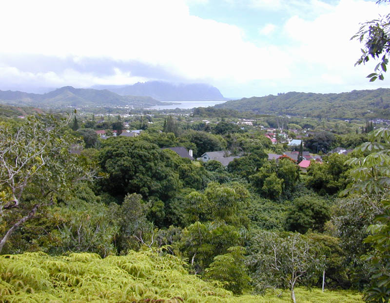
imagesize = 250px
image_caption = okinaĀhuimanu looking towards Kāneokinaohe Bay
flag_size =
image_
seal_size =
image_shield =
shield_size =
image_blank_emblem =
blank_emblem_type =
blank_emblem_size =
flag_size =
image_
seal_size =
image_shield =
shield_size =
image_blank_emblem =
blank_emblem_type =
blank_emblem_size =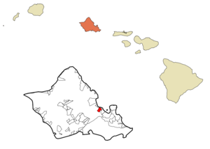
mapsize =
map_caption = Location in Honolulu County and the state ofHawaii
mapsize1 =
map_caption1 =
image_dot_
dot_mapsize =
dot_map_caption =
dot_x =
dot_y =
pushpin_
pushpin_label_position =
pushpin_map_caption =
pushpin_mapsize =
subdivision_type = Country
subdivision_name =United States
subdivision_type1 = State
subdivision_name1 =Hawaii
subdivision_type2 =
subdivision_name2 =
subdivision_type3 =
subdivision_name3 =
subdivision_type4 =
subdivision_name4 =
government_footnotes =
government_type =
leader_title =
leader_name =
leader_title1 =
leader_name1 =
leader_title2 =
leader_name2 =
leader_title3 =
leader_name3 =
leader_title4 =
leader_name4 =
established_title =
established_date =
established_title2 =
established_date2 =
established_title3 =
established_date3 =
area_magnitude =
unit_pref = Imperial
area_footnotes =
area_total_km2 = 4.6
area_land_km2 = 4.6
area_water_km2 = 0.0
area_total_sq_mi = 1.8
area_land_sq_mi = 1.8
area_water_sq_mi = 0.0
area_water_percent =
area_urban_km2 =
area_urban_sq_mi =
area_metro_km2 =
area_metro_sq_mi =
area_blank1_title =
area_blank1_km2 =
area_blank1_sq_mi =
population_as_of = 2000
population_footnotes =
population_note =
population_total = 8506
population_density_km2 = 1832.1
population_density_sq_mi = 4745.1
population_metro =
population_density_metro_km2 =
population_density_metro_sq_mi =
population_urban =
population_density_urban_km2 =
population_density_urban_sq_mi =
population_blank1_title =
population_blank1 =
population_density_blank1_km2 =
population_density_blank1_sq_mi =
timezone = Hawaii-Aleutian
utc_offset = -10
timezone_DST =
utc_offset_DST =
latd = 21
latm = 26
lats = 36
latNS = N
longd = 157
longm = 50
longs = 24
longEW = W
elevation_footnotes =
elevation_m = 25
elevation_ft = 82
postal_code_type =
postal_code =
area_code = 808
blank_name = FIPS code
blank_info = 15-00400
blank1_name = GNIS feature ID
blank1_info = 0358445
website =
footnotes = okinaĀhuimanu is acensus-designated place (CDP) located in the City & County of Honolulu, District of Kookinaolaupoko, island of Ookinaahu, Hawaiokinai. In Hawaiian "okinaāhui-manu" means "cluster of birds".okinaĀhuimanu is spread out beneath the steep windward "pali" (cliff face) of the Kookinaolau mountain and separated by a low ridge from Heokinaeia Kea. Thus, this area is mostly inland and not directly on Kāneokinaohe Bay. However, one neighborhood spreads over the ridge and along Kamehameha Highway where there is private access to the Bay shore. Proximity to the "pali" gives the place a generally wet climate. As of the 2000 Census, this largely residential area had a total population of 8,506. A small commercial mall is located here across the highway from the Valley of the Temples Memorial Park, a large cemetery noted for its Byodo-in Temple.
The U.S.
postal code for okinaĀhuimanu is 96744.Geography
okinaĀhuimanu is located at 21°26'36" North, 157°50'24" West (21.443273, -157.840111)GR|1. The towns closest to okinaĀhuimanu are Heokinaeia and Kāneokinaohe to the south along State Rte 83 (Kahekili Hwy) and Kahaluokinau with which it merges to the north.
According to the
United States Census Bureau , the CDP has a total area of 1.8 square miles (4.6km² ), of which, 1.8 square miles (4.6 km²) of it is land and none of it is covered by water.Demographics
As of the 2000 CensusGR|2, there were 8,506 people, 2,591 households, and 2,204 families residing in okinaĀhuimanu. The
population density was 4,745.1 people per square mile (1,834.7/km²). There were 2,681 housing units at an average density of 1,495.6/sq mi (578.3/km²). The racial makeup of the CDP was 22.27% White, 0.95% Black or African American, 0.14% Native American, 34.72% Asian, 9.85% Pacific Islander, 0.66% from other races, and 31.41% from two or more races. 8.12% of the population were Hispanic or Latino of any race.There were 2,591 households out of which 41.4% had children under the age of 18 living with them, 68.9% were married couples living together, 11.2% had a female householder with no husband present, and 14.9% were non-families. 10.0% of all households were made up of individuals and 2.4% had someone living alone who was 65 years of age or older. The average household size was 3.28 and the average family size was 3.51.
In the CDP the population was spread out with 27.9% under the age of 18, 8.3% from 18 to 24, 28.7% from 25 to 44, 28.1% from 45 to 64, and 7.0% who were 65 years of age or older. The median age was 36 years. For every 100 females there were 98.3 males. For every 100 females age 18 and over, there were 95.6 males.
The median income for a household in the CDP was $71,732, and the median income for a family was $74,788. Males had a median income of $47,910 versus $37,929 for females. The
per capita income for the CDP was $25,381. 3.9% of the population and 2.8% of families were below thepoverty line . Out of the total population, 3.8% of those under the age of 18 and 1.4% of those 65 and older were living below the poverty line.References
External links
Wikimedia Foundation. 2010.