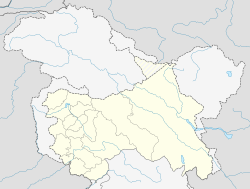
Nagrota

Nagrota
Nagrota
—  town  —
Nagrota
Location of Nagrota
in Jammu and Kashmir and India
Coordinates 32°49′00″N 74°55′00″E / 32.81667°N 74.91667°E / 32.81667; 74.91667Coordinates: 32°49′00″N 74°55′00″E / 32.81667°N 74.91667°E / 32.81667; 74.91667
Country India
State Jammu and Kashmir
District(s) Jammu
Nearest city Jammu
Time zone IST (UTC+05:30)

Nagrota (Dogri: नग्रोटा, Urdu: نگروٹہ) is a town located in the Jammu district of Jammu and Kashmir state in India. It is located on National Highway 1A (NH1A) between Jammu city and Udhampur. The town straddles the national highway, with a few additional minor roads.

Though Nagrota does not have a railway station, it does have a Railway Station Code assigned (NGRT) in preparation for the completion of the planned Jammu-Srinagar railway extension.

Cantonment and 16 Corps

There is a large Nagrota Cantonment located in Nagrota, which is the home of 16 Corps, the largest Corps in the Indian Army. A Military Police checkpost is located at the entry point.cantonment.[1]

See also

References

  1. ^ "Nagrota Corps / XVI Corps / White Knight Corps". GlobalSecurity.org. Accessed 2009-10-06.


Wikimedia Foundation. 2010.

Игры ⚽ Поможем написать реферат

Look at other dictionaries:

  • Nagrota — Original name in latin Nagrota Name in other language State code IN Continent/City Asia/Kolkata longitude 32.05 latitude 76.08333 altitude 443 Population 6125 Date 2006 01 17 …   Cities with a population over 1000 database

  • Nagrota Bagwan —   city   …   Wikipedia

  • Sainik School — The Sainik schools are a system of schools in India conceived in 1961 by V.K. Krishnamenon to rectify the regional and class imbalance amongst the Officer cadre of the Indian Military. The inspiration for Sainik Schools came from the Rashtriya… …   Wikipedia

  • Ahluwalia — Infobox caste caste name=Ahluwalia classification=Kshatriya (Chandravanshi or Somavanshi) subdivisions=Bhagat, Bhambral,Bhandari, Bhar,Bimat,Bontra, Caprahaan,Dhaul, Diwan,Jaardi,Judge or, Jaaj,Josh, Kandel,Kent,Ludhatia, Malihan,Malik, Mumick or …   Wikipedia

  • Maharana Pratap Sagar — Pong Dam Lake View of Reservoir behind Pando Dam Location Kangra district, Himachal Pradesh Coordinates …   Wikipedia

  • List of India-related articles — Articles (arranged alphabetically) related to India or Indian culture include: NOTOC List of India related topics People are listed by their first names. 1231 SGM 3 STR 2002 Gujarat violence 2005 in India ( previous years ) 2004 Indian Ocean… …   Wikipedia

  • Jammu — This article is about the municipality in India. For its namesake district, see Jammu district. For other uses, see Jammu (disambiguation). Jamamu redirects here. For other uses, see Jamamu (disambiguation). Jammu …   Wikipedia

  • Kangra district — Kangra is the most populous district of the state of Himachal Pradesh, India. Dharamsala is the administrative headquarters of the district.GeographyThe district is in the western part of Himachal Pradesh, in the low foothills of the Himalayas.… …   Wikipedia

  • Cantonment — Cantonment, Florida is town north of Pensacola, Florida. See also Canton and Cantonist A cantonment is a temporary or semi permanent military quarters.Oxford English Dictionary cantonment] The word cantonment is derived from the French word… …   Wikipedia

  • Udhampur District — Udhampur is a district in Jammu and Kashmir. The town of Udhampur is the Headquarter of this district.The 2001 census indicates the population of the district to be just over 700,000. There are 871 females for every 1000 males in the district.… …   Wikipedia

Share the article and excerpts

Direct link
Do a right-click on the link above
and select “Copy Link”