Doun Kaev District

Doun Kaev District
Doun Kaev
ស្រុកដូនកែវ
—  District (srok)  —
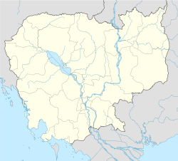
Doun Kaev is located in Cambodia
Doun Kaev
Location in Cambodia
Coordinates: 11°10′N 105°40′E / 11.167°N 105.667°E / 11.167; 105.667Coordinates: 11°10′N 105°40′E / 11.167°N 105.667°E / 11.167; 105.667
Country  Cambodia
Province Takéo
Communes 6
Villages 34
Time zone +7
Geocode 2108

Doun Kaev District is a district located in Takéo Province, in southern Cambodia. According to the 1998 census of Cambodia, it had a population of 39,186.[1]

References

  1. ^ "General Population Census of Cambodia 1998, Final Census Results". National Institute of Statistics, Ministry of Planning, Cambodia. August, 2002. http://www.nis.gov.kh/nis/uploadFile/pdf/CensusResult98.pdf. Retrieved 2010-11-25.  See page 269.


Wikimedia Foundation. 2010.

Игры ⚽ Нужно сделать НИР?

Look at other dictionaries:

  • Mongkol Borei District — Mongkol Borei ស្រុកមង្គលបុរី   District (srok)   Map showing the location of the district within Banteay Meanchey Province …   Wikipedia

  • Moung Ruessei District — Moung Ruessei ស្រុកមោងឫស្សី   District (srok)   Country  Cambodia …   Wikipedia

  • Memot District — Memot ស្រុកមេមត់   District (srok)   …   Wikipedia

  • Cheung Prey District — Cheung Prey ស្រុកជើងព្រៃ   District (srok)   …   Wikipedia

  • Chamkar Leu District — Chamkar Leu ស្រុកចំការលើ   District (srok)   …   Wikipedia

  • Ou Reang Ov District — Ou Reang Ov ស្រុកអូរាំងឪ   District (srok)   …   Wikipedia

  • Dambae District — Dambae ស្រុកដំបែ   District (srok)   …   Wikipedia

  • Ou Chum District — For the commune and the village, see Ou Chum (commune). Ou Chum អូរជុំ   District   …   Wikipedia

  • Ou Ya Dav District — Ou Ya Dav អូរយ៉ាដាវ   District   Location of Ou Ya Dav in Ratanakiri …   Wikipedia

  • Ou Chrov District — Ou Chrov ស្រុកអូរជ្រៅ   District (srok)   The Thai Cambodian border crossing at Poipet …   Wikipedia

Share the article and excerpts

Direct link
Do a right-click on the link above
and select “Copy Link”