- Banteay Meanchey Province
Infobox Cambodian Province
name = Banteay Meanchey
khmer = បន្ទាយមានជ័យ
area = 6,679
population = 577,772
population_as_of = 1998
density = 86.5
isocode = KH-1
capital =Sisophon
districts = 8
communes = 64
villages = 624 | map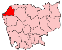
Banteay Meanchey is a Cambodian province. It is in the northwest of the country, and its capital is
Sisophon . The townPoipet is the border crossing toThailand .Banteay Meanchey means in the Khmer Language "Fortress of Victory".
Geography
Banteay Meanchey is located in the northwest of the country, bordering
Thailand to the north and west. Neighboring provinces areOddar Meancheay to the northeast, Siem Reap to the east, and Battambang to the south. To the west is the Thai province Sa Kaeo, to the north Buriram.Poipet is a town on theThailand /Cambodia border . It is a key crossing point between the two countries, and also extremely popular as agambling destination as gambling is popular, but illegal in Thailand. There is a strip ofcasino s and hotels between the Thai and Cambodian passport control counters, enabling Thais to gamble in Cambodia without needing to go through Cambodian immigration.Poipet is adjacent to the city of
Aranya Pratet on the Thai side of the border.The province is mostly covered by extensive lowlands, with only a few uplands to the north and east. Main rivers are the
Mongkol Borei River and theSisophon River . [cite web|url=http://mirror.undp.org/carere/Layer2.Project_Activities/summaryLDFprodoc.htm|title=UNCDF Local Development Fund Project Document - 1996]History
The area was part of the extensive
Khmer empire , with its most notable remains theBanteay Chhmar temple in the north of the province, built in 12th century towards the 13th century.In the 17th century
Siam took control over Cambodia, and made the area of the modern province part ofSisophon Province . In 1907 Siam had to cede control to the French, and it was then included into Battambang Province.In 1988 the province Banteay Meanchey was split off from Battambang, originally consisting of the five districts Mongkol Borei, Thmar Pouk, Serei Sophorn, Preah Netpreah and Phnom Srok. [cite web|title=Background of Battambang In the past and the present|url=http://www.battambang-town.gov.kh/city_info/anzeige/redaktionssystem/main/show.cfm?region_id=27&lang_id=3&id=253&modul_id=5|published=Battambang town]
Administration
The province is subdivided into 8 districts ("
srok "), which are further subdivided in 64 communes ("khum ") and 634 villages ("phum ") [ [http://www.cambodia.gov.kh/unisql1/egov/english/province/banteay_meanchey.html Royal Government of Cambodia] ] .
*0102 Mongkol Borei (មង្គលបុរី)
*0103Phnom Srok (ភ្នំស្រុក)
*0104Preah Netr Preah (ព្រះនេត្រព្រះ)
*0105Ou Chrov (អូរជ្រៅ)
*0106Serei Saophoan (សិរីសោភ័ណ)
*0107Thma Puok (ថ្មពួក)
*0108Svay Chek (ស្វាយចេក)
*0109Malaii (ម៉ាល័យ)Numbers according to National Institute of Statistics [cite web|url=http://www.stats.nis.gov.kh/areaname/dist_pro01.htm|publisher=National Institute of Statistics, Cambodia|title=Districts of Banteay Meanchey]References
External links
* [http://www.cambodia.gov.kh/unisql1/egov/english/province/banteay_meanchey.html Administration by the Cambodian government]
* [http://www.moc.gov.kh/national_data_resource/Provincial%20Resources/Banteay%20Meanchey/Banteay%20Meanchey%20Provincial%20Resources.htm Province Resources at Ministry of Commerce]
Wikimedia Foundation. 2010.