- Bar Kaev District
Infobox Settlement
name =Bar Kaev
settlement_type =District
official_name =
other_name =
native_name =
nickname =
motto =
imagesize =
image_caption =
flag_size =
image_
seal_size =
image_shield =
shield_size =
image_blank_emblem =
blank_emblem_size =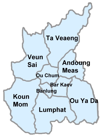
mapsize = 250px
map_caption = PAGENAME location in Ratanakiri Province
mapsize1 =
map_caption1 =
pushpin_
pushpin_label_position =
subdivision_type = Country
subdivision_name =
subdivision_type1 = Province
subdivision_name1 =Ratanakiri Province
subdivision_type2 =
subdivision_name2 =
seat_type =
seat =
government_type =
leader_title =
leader_name =
leader_title1 =
leader_name1 =
established_title =
established_date =
area_magnitude =
unit_pref =Imperial
area_footnotes =
area_total_km2 =
area_land_km2 =
area_water_km2 =
area_total_sq_mi =
area_land_sq_mi =
area_water_sq_mi =
area_water_percent =
area_urban_km2 =
area_urban_sq_mi =
area_metro_km2 =
area_metro_sq_mi =
population_as_of = 1998
population_footnotes =
population_note =
population_total =11,758
population_density_km2 =
population_density_sq_mi =
population_metro =
population_density_metro_km2 =
population_density_metro_sq_mi =
population_urban =
population_density_urban_km2 =
population_density_urban_mi2 =
timezone = GMT + 7
utc_offset = +7
timezone_DST =
utc_offset_DST =
latd=|latm=|lats=|latNS=
longd=|longm=|longs= |longEW=
elevation_footnotes =
elevation_m =
elevation_ft =
postal_code_type =
postal_code =
area_code =
website =
footnotes =Bar Kaev District ( _km. បាគាវ) (also transliterated "Bar Keo") is a district in north-eastern
Cambodia , located inRatanakiri Province , Population 11,758 (1998). [ [http://www.moc.gov.kh/national_data_resource/Provincial%20Resources/Ratanakiri/Index.htm "Rotanak Kiri Provincial Resources"] .Cambodia National and Provincial Resources Data Bank (2003). AccessedMay 5 ,2008 .] It contains six communes.References
Wikimedia Foundation. 2010.