- Mondulkiri Province
-
Mondulkiri
មណ្ឌលគីរី— Province — Tourists at Bou Sra Waterfall.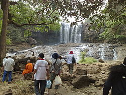 Map of Cambodia highlighting Mondulkiri
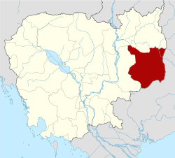
Coordinates: 12°27′N 107°14′E / 12.45°N 107.233°ECoordinates: 12°27′N 107°14′E / 12.45°N 107.233°E Country  Cambodia
Capital Sen Monorom Area – Total 14,288 km2 (5,516.6 sq mi) Population (2008)[1] – Total 60,811 – Density 4.3/km2 (11/sq mi) Time zone UTC+07 Dialing code +855 ISO 3166 code KH-11 Districts 5 Communes 21 Villages 98 Mondulkiri (Khmer: មណ្ឌលគីរី, literally: "Mountain of the Mandala.") is an eastern province of Cambodia. It is the most sparsely populated province in the country despite being the largest in land area. The capital is the town of Senmonorom.
Contents
Geography and environment
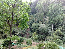 Dense forests of Mondulkiri Province.
Mondulkiri is known for its forested hills and powerful waterfalls. Some waterfalls include:
- Bou Sra Waterfall. Located at Pich Chinda District, 43 kilometers from Senmonorom town, Bou Sra is the largest waterfall, made famous by a popular Khmer song in Mondulkiri.
- Senmonorom Waterfall. Five kilometers from town and an easy walk, Senmonorom waterfall is not much to look at and used to be a nice picnic spot until the construction of a Japanese built hydro electric power station that cut the flow of water.
- Romnea Waterfall. Ten kilometers from Senmonorom, Romnea waterfall is actually 1 of 3 large waterfalls that has now been deforested and privatised.
Mondulkiri faces a significant threat from illegal loggers attempting to exploit the area's virgin forests.[2]
Districts
The province is subdivided into 5 districts, which are further subdivided into 21 communes and 98 villages.
- 1101 Kaev Seima - កែវសីម៉ា
- 1102 Kaoh Nheaek - កោះញែក
- 1103 Ou Reang - អូររាំង
- 1104 Pech Chenda - ពេជ្រចិន្តា
- 1105 Senmonorom - សែនមនោរម្យ
Demographics
Eighty percent of Mondulkiri's population is made up of ten tribal minorities, with the majority of them being Pnong. The remaining 20 percent are Khmer, Chinese, and Muslims Cham.
Economy and transportation
The population lives off the land, planting rice, fruit trees, and a variety of vegetables. Others grow strawberries, coffee, rubber, and cashew nuts.
Road development continues to impact seriously on indigenous communities like the Pnong ethnic group. According to a United Nations paper, the construction of a road from Mondulkiri to Ratanakiri has resulted in massive land grabbing.[3]
Culture
Although more and more houses are built in 'Khmer style', traditional Phnong houses can still be found. Pnong houses contain large jars (which are said to be more than a thousand years old) and traditional gongs. There are various gongs used at different occasions. Jars and gongs are among the most valuable possessions of indigenous communities both in traditional and spiritual as well as material terms. During the times of Pol Pot those objects were buried in hidden places in the jungle and in many cases they still wait in the ground.
Location

Stung Treng Province Ratanakiri Province Kratie Province 
Dak Lak province,  Vietnam
 Mondulkiri Province

Kratie Province Binh Phuoc province, VietnamDak Nong province, VietnamReferences
- ^ "General Population Census of Cambodia 2008 - Provisional population totals" (PDF). National Institute of Statistics, Ministry of Planning. 3 September 2008. http://www.stat.go.jp/english/info/meetings/cambodia/pdf/pre_rep1.pdf.
- ^ Illegal Logging in Mondulkiri – a Test Case for Forest Sector Law Enforcement, Global Witness.
- ^ Permanent Forum on Indigenous Issues, Economic and Social Council, United Nations.
 Mondulkiri Province
Capital city 
Districts Places Provinces of Cambodia Provinces Banteay Meanchey · Battambang · Kampong Cham · Kampong Chhnang · Kampong Speu · Kampong Thom · Kampot · Kandal · Koh Kong · Kratié · Mondulkiri · Oddar Meancheay · Pursat · Preah Vihear · Prey Veng · Ratanakiri · Siem Reap · Stung Treng · Svay Rieng · Takéo
Municipalities Categories:- Mondulkiri Province
- Provinces of Cambodia


Wikimedia Foundation. 2010.