Mount Shirakami

Mount Shirakami
Mount Shirakami
白髪山

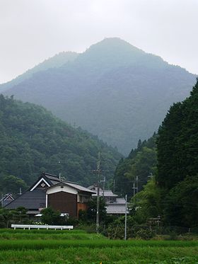
A View of Mt. Shirakami from Sumiyama
Elevation 721.8 m (2,368 ft)
Pronunciation Japanese: [ɕiɽakami jama]
Location
Location Himeji, Hyōgo in Japan
Range Tamba Highland
Coordinates 35°2′N 135°8′E / 35.033°N 135.133°E / 35.033; 135.133
Geology
Type Ruins

Mount Shirakami (白髪山 Shirakami-yama?) is a 721.4 meter high mountain in Sasayama, Hyōgo, Japan. Another name is Tamba-Fuji, literally, 'Mount Fuji in Tamba Province'. This mountain is one of the Hyōgo 50 mountains, and Kinki 100 mountains.

Contents

Outline

Mount Shirakami is one of the most famous mountains in Tamba Highland, well-known for its good shape like famous Mount Fuji. This mountain is an independent mountain in this area, and visitors can enjoy the almost 360 degree panorama view from the top. This mountain is the source of Mukogawa River.

Religion and History

Mount Shirakami was an object of worship of the people in this area with Mount Matsuo. This mountain is located near an old route from Osaka to Tajima Province, or Kyoto to Harima Province, so the good-shape of the mountain has attracted many people in the history. After the Battle of Ichi-no-Tani in the 12th century, a legend said that one of a wife of the lost samurai of Heike, lived on the foot of the mountain and a found her husband.

Access

References


Wikimedia Foundation. 2010.

Игры ⚽ Поможем сделать НИР

Look at other dictionaries:

  • Mount Matsuo — 松尾山 A View of Mt. Matsuo from Mount Shirakami Elevation …   Wikipedia

  • Mount Ōmine — 大峰山 Elevation 1,719 m (5,640 ft) …   Wikipedia

  • Mukogawa River — A Source of Mukogawa River Mukogawa and Takarazuka Grand Theater at Takarazuka …   Wikipedia

  • Furuichi Station (Hyōgo) — nihongo|Furuichi Station (Hyogo)|古市駅|Furuichi eki is a railway station in Sasayama, Hyogo, Japan, on the Fukuchiyama Line (JR Takarazuka Line) operated by West Japan Railway Company. It is located near Mount Shirakami and Mount Matuo. Trains… …   Wikipedia

  • Extreme points of Japan — The extreme points, the points that are farther north, south, east or west than any other location in Japan, are the following.Nation; Northernmost point *Under Japanese control::nihongo|Bentenjima|弁天島, Cape Sōya, Wakkanai, Hokkaidō… …   Wikipedia

  • Wikiproyecto:Patrimonio de la Humanidad — Patrimonio de la Humanidad …   Wikipedia Español

  • List of World Heritage Sites in Asia and Australasia — This is a list of the UNESCO World Heritage Sites in Asia, Australia and the Pacific (Australia). Several countries from the European list are repeated here (Turkey, Azerbaijan, Armenia and Georgia) as well as the Asian parts of Russia and… …   Wikipedia

  • List of old growth forests — This is a list of existing old growth ( virgin ) forests, or remnants of forest. (NB: The terms old growth and virgin may have various definitions and meanings throughout the world. See old growth forest for more information.)EurasiaBelarus*… …   Wikipedia

  • Liste des UNESCO-Welterbes (Asien und Ozeanien) — Dies ist die nach Ländern geordnete Liste der UNESCO Welterbestätten auf dem Kontinent Asien sowie in Ozeanien, wozu die UNESCO auch den Kontinent Australien zählt. Die Zahl am Anfang jeder Zeile bezeichnet das Aufnahmejahr der Stätte in die… …   Deutsch Wikipedia

  • Aomori Prefecture — Infobox Prefecture Japan Name = Aomori JapaneseName = 青森県 Rōmaji = Aomori ken Symbol = PrefSymbol Aomori.png Capital = Aomori (city) Region = Tōhoku Island = Honshū TotalArea = 9,606.26 AreaRank = 8th PCWater = 1.2 PopDate = October 1, 2000… …   Wikipedia

Share the article and excerpts

Direct link
Do a right-click on the link above
and select “Copy Link”