- O'Kean, Arkansas
-
O'Kean, Arkansas — Town — Location in Randolph County and the state of Arkansas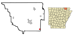
Coordinates: 36°10′5″N 90°48′57″W / 36.16806°N 90.81583°WCoordinates: 36°10′5″N 90°48′57″W / 36.16806°N 90.81583°W Country United States State Arkansas County Randolph Area – Total 1 sq mi (2.6 km2) – Land 1 sq mi (2.6 km2) – Water 0 sq mi (0 km2) Elevation 276 ft (84 m) Population (2000) – Total 201 – Density 201/sq mi (77.3/km2) Time zone Central (CST) (UTC-6) – Summer (DST) CDT (UTC-5) ZIP code 72449 Area code(s) 870 FIPS code 05-51500 GNIS feature ID 0077867 O'Kean is a town in Randolph County, Arkansas, United States. The population was 201 at the 2000 census.
Contents
Geography
O'Kean is located at 36°10′5″N 90°48′57″W / 36.16806°N 90.81583°W (36.167956, -90.815846),[1] bordered by Greene County to the east, and one mile north of Lawrence County.
O'Kean was founded in 1869 in the southeast corner of Randolph County. Named after Father James P. O'Kean of St. Paul's Catholic Church in Pocahontas, O'Kean was located around the St. Louis & Iron Mountain Railroad. O'Kean possesses a mayor/council type government.
According to the United States Census Bureau, the town has a total area of 2.6 km² (1.0 mi²), all land.
List Of Highways
 Highway 34
 Highway 90
Demographics
As of the census[2] of 2000, there were 201 people, 85 households, and 58 families residing in the town. The population density was 77.6/km² (200.5/mi²). There were 93 housing units at an average density of 35.9/km² (92.8/mi²). The racial makeup of the town was 96.52% White, 0.50% Pacific Islander, and 2.99% from two or more races. 0.50% of the population were Hispanic or Latino of any race.
There were 85 households out of which 25.9% had children under the age of 18 living with them, 65.9% were married couples living together, 3.5% had a female householder with no husband present, and 30.6% were non-families. 27.1% of all households were made up of individuals and 11.8% had someone living alone who was 65 years of age or older. The average household size was 2.36 and the average family size was 2.90.
In the town the population was spread out with 20.4% under the age of 18, 9.0% from 18 to 24, 23.9% from 25 to 44, 31.8% from 45 to 64, and 14.9% who were 65 years of age or older. The median age was 42 years. For every 100 females there were 91.4 males. For every 100 females age 18 and over, there were 100.0 males.
The median income for a household in the town was $24,688, and the median income for a family was $35,208. Males had a median income of $16,667 versus $16,750 for females. The per capita income for the town was $11,342. About 22.6% of families and 24.3% of the population were below the poverty line, including 34.8% of those under the age of eighteen and 9.5% of those sixty five or over.
References
- ^ "US Gazetteer files: 2010, 2000, and 1990". United States Census Bureau. 2011-02-12. http://www.census.gov/geo/www/gazetteer/gazette.html. Retrieved 2011-04-23.
- ^ "American FactFinder". United States Census Bureau. http://factfinder.census.gov. Retrieved 2008-01-31.
Municipalities and communities of Randolph County, Arkansas City 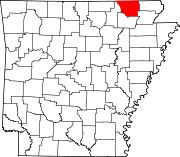
Towns Biggers | Maynard | O'Kean | Ravenden Springs | Reyno
Unincorporated
communityWarm Springs
Categories:- Populated places in Randolph County, Arkansas
- Towns in Arkansas


Wikimedia Foundation. 2010.