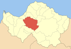
- Farres
-
Farres
ΦαρρέςLocation Coordinates 38°6′N 21°47′E / 38.1°N 21.783°ECoordinates: 38°6′N 21°47′E / 38.1°N 21.783°E Government Country: Greece Region: West Greece Regional unit: Achaea Municipality: Erymanthos Population statistics (as of 2001) Municipal unit - Population: 6,300 - Area: 241.85 km2 (93 sq mi) - Density: 26 /km2 (67 /sq mi) Other Time zone: EET/EEST (UTC+2/3) Elevation (min-max): 50 - 100 m (164 - 328 ft) Postal: 250 08 Telephone: 26940 Auto: ΑΧ Website www.farron.gr Farres (Greek: Φαρρές) is a former municipality in Achaea, West Greece, Greece. Since the 2011 local government reform it is part of the municipality Erymanthos, of which it is a municipal unit.[1] Its seat of administration was in the town Chalandritsa. It is on a road connecting Patras and Kalavryta. It is located about 17 km SSW of Patras, about 40 km south of the Rio-Antirio bridge/, about 70 km SW of Aigio, 55 km W of Kalavryta, about 140 km NW of Tripoli and about 10 km from GR-9/Patras By-Pass.
The municipality was first founded in 1835, it was dissolved in 1912, then restored in 1998 under the Capodistria Plan.
Contents
Subdivisions
The municipal unit Farres is subdivided into the following communities (constituent villages in brackets):
- Chalandritsa (Chalandritsa, Kydonies, Mastoraiika-Stamaiika)
- Chrysopigi (Chrysopigi, Ano Chrysopigi)
- Elliniko (Elliniko, Agia Eleousa, Koumaris, Neochori, Chrysavgi)
- Fares (Fares, Prevedos)
- Isoma
- Kalanistra (Kalanistra, Rodia)
- Kalanos
- Kalousi
- Katarraktis
- Kritharakia (Kritharakia, Asteri, Toskes)
- Lakkomata (Lakkomata, Tsapournia)
- Mirali
- Neo Kompigadi (Neo Kompigadi, Michas, Platanos)
- Platanovrysi (Platanovrysi, Agia Paraskevi, Kato Platanovrysi, Koimisis)
- Starochori (Ano Starochori, Dafnoula, Kato Starochori, Trousas)
- Vasiliko (Vasiliko, Agrilia, Kydonies, Sterna, Stefani)
Historical population
Year Population 1991 6,483 2001 6,262 History
Pre-Modern Farres
The area near Agios Georgios nearly 1 km from Chalandritsa had a Mycenaean settlement, a few buildings and artifacts have been excavated in 1985. Its settlement founded perimetrically by the hill and also in the center think that there was a building or a temple nearby. There is no recording of the settlement name. The area during the Frankish times was a barony. It was founded by the Tremouille family and later the Zacharias family. Its first baron was Odebert de Tremouille (Ωδεβέρτος ντε Τρεμουϊγ - Odevertos de Tremouille), a tower was later built. Later, the area fell to the Venetians and the Ottomans which lasted until 1821 during the Greek War of Independence which got freedom from the Turks, during the Venetian rule, it was part of the Barony of Patras, after the Orlov Revolt with the French adventurer Goufiet was deserted. On February 26, 1822, 2,000 Turks fought and battled. Its economy improved. Emigration began during the Between the Wars period. In the Greek Civil War, on July 5, 1948, it was entered to the Democratic army, the battle continued for six days, it did not return to the anti-Communists until the end.
Farres today
After World War II and the civil war, its buildings were rebuilt. Pavement was linked in the 1950s on both roads, radios, phone lines and automobiles in the mid to late-1960s along with television later on. More paved roads were added between. the 1970s and the 1990s. Chalandritsa along with the municipality was struck by two earthquakes on February 5, 2008 that measured at 5.5 on the Richter scale, nearly no damages were reported, its buildings shook. The epicenter for the first one was near Chalandritsa, the second one that occurred half an hour later was epicentered at Farres just 15 km west of Chalandritsa.
Farmlands are to its west. The central part is made up of farmlands which includes mixed farming and pastures in a plain named Farron-Chalandritsa while the eastern and the western part are made up of forests, mountains and valleys.
Points of interests
It has a Frankish tower, the Folklore Art Museum And Local History (the buildings known as Neromylos and Nerotrivi). Near Rendes or Rentes is the constructed Patras Raceway.
Sporting teams
- A.P.S. Doxa Chalandritsa - the only club in the village, it plays with a dry field.
Sources
- Chalandritsa ('Η Χαλανδρίτσα = Halandritsa), Stefanos Thomopoulos, 1937
References
- ^ Kallikratis law Greece Ministry of Interior (Greek)
Notes
- History Of The Cities Of Patras, Volume I & II (Ιστορία της πόλεως Πατρών , Τόμοι Α΄& Β΄ = Istoria tis poleos Patron, Tomi I & II), Stefanos Thomopoulos, Achaikes Ekdoseis ISBN 9607960106
- Archaies poleis perix tis Olympias (Αρχαίες πόλεις πέριξ της Ολυμπίας = Ancient Cities Beyond Olympia, Vasilis Taktikos, Athanasios Koumartzis, Anadrasi, Athens 2002
- O emfylios polems stin Achaia (Ο εμφύλιος πόλεμος στην Αχαία = The Civil War in Achaia), Vasileios Lazaris, Sygchroni Epochi, Athens, 2006 ISBN 9604510177
External links
Northwest: Vrachnaiika North: Messatida Northeast: Leontio West: Olenia Farres East: Kalavryta South: Tritaia Municipal unit of Farres Chalandritsa · Chrysopigi · Elliniko · Fares · Isoma · Kalanistra · Kalanos · Kalousi · Katarraktis · Kritharakia · Lakkomata · Mirali · Neo Kompigadi · Platanovrysi · Starochori · VasilikoMunicipal unit of Kalentzi Municipal unit of Leontio Municipal unit of Tritaia Agia Varvara · Agia Marina · Alpochori · Chiona · Drosia · Erymantheia · Kalfas · Manesi Patron · Roupakia · Skiadas · Skouras · Spartia · Stavrodromi · VelimachiCategories:- Populated places in Achaea
- Populated places established in 1835
Wikimedia Foundation. 2010.


