- Owston Ferry
-
Coordinates: 53°29′43″N 0°47′08″W / 53.495228°N 0.785656°W
Owston Ferry 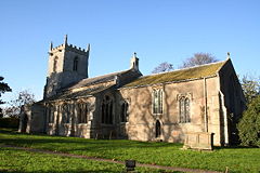
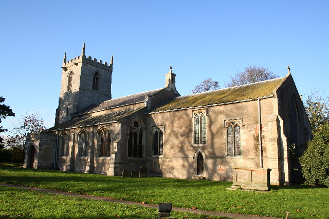
Church of St Martin, at Owston Ferry
 Owston Ferry
Owston Ferry shown within LincolnshirePopulation 1,128 (2001 Census) OS grid reference SE805005 - London 140 mi (230 km) SSE Unitary authority North Lincolnshire Ceremonial county Lincolnshire Region Yorkshire and the Humber Country England Sovereign state United Kingdom Post town DONCASTER Postcode district DN9 Dialling code 01427 Police Humberside Fire Humberside Ambulance East Midlands EU Parliament Yorkshire and the Humber List of places: UK • England • Lincolnshire Owston Ferry is a village and civil parish in North Lincolnshire, England. It lies on the west bank of the River Trent, 9 miles (14 km) north of Gainsborough, and has a total resident population of 1,128.[1]
Sometimes referred to in short as Owston or Ferry, the village, which forms part of the Isle of Axholme, is bounded to the west by the A161 road and the village of Haxey. The River Trent is directly to the east. To the north, beyond a number of hamlets and villages, lies the River Humber. West Butterwick was originally a part of the township of Owston.
Owston Ferry appears in the Domesday Book of 1086 under "Ostone". Owston Ferry Castle, also known as Kinnard's Ferry Castle, was a motte-and-bailey fortification from the 12th century. It lay on the site of an earlier, Roman castrum. It was dismantled by order of Henry II of England in 1175-76 following the Revolt of 1173–1174.
Contents
History
Further information: History of LincolnshireThe name "Owston" is thought to derive from the Old Norse "austr+tun", meaning "east farmstead",[2] a view shared by other sources which outline that it specifically implied the "farmstead east of Haxey".[3] The name "Owston" is shared by at least two other settlements within the United Kingdom. In the 1086 Domesday Book, it was rendered as "Ostone",[3] with the suffix "Ferry" (thought to imply the water vessel which may have been used to cross the Trent), in abeyance.
Owston Ferry Castle, also known as Kinnard's Ferry Castle, was a motte-and-bailey fortification from the 12th century. It lay on the site of an earlier, Roman castrum.[4] It was dismantled by order of Henry II of England in 1175-76 following the Revolt of 1173–1174.[5]
Owston Ferry Grade I listed Anglican parish church is dedicated to St Martin.[6] The church register dates from 1603.[7]
In 1885 Kelly's reported the existence of Wesleyan Primitive Methodist chapels,[8] a rope-walk, boat-building yard, several corn mills, and the manufacture of sacking and sail cloth. The parish was of 5,350 acres. Wheat, barley, potatoes, beans and grass were grown.[7]
Governance
As part of the provisions of the Local Government Act 1972, Owston Ferry formed part of the Boothferry district of the county of Humberside, having previously lain within the Parts of Lindsey from the historic county boundaries of Lincolnshire. Since 1996 however, Owston Ferry has formed part of the unitary authority area of North Lincolnshire.
Geography
At 53°29′42.8″N 0°47′8.3″W / 53.495222°N 0.785639°W (53.495228°, -0.785656°), and 140 miles (225 km) north-northwest of London, Owston Ferry stands on flat ground by the River Trent, opposite the hamlet of East Ferry.
The closest motorway to Owston Ferry is the M180, whilst Robin Hood Airport is eight miles to the south east, in South Yorkshire.
The civil parish of Owston Ferry, includes the village of Owston Ferry, as well as a number of smaller localities, including West Ferry, Gunthorpe, Heckdyke and Melwood.
Education
Owston Ferry only contains one primary school, St. Martin's Church of England Primary School.
Notable people
Epworth-born Alexander Kilham, founder of the Methodist New Connexion, worked in Owston Ferry during his teens.[9]
See also
- East Ferry
- Trent Aegir
References
- ^ United Kingdom Census 2001. "Owston Ferry CP (Parish)". neighbourhood.statistics.gov.uk. http://www.neighbourhood.statistics.gov.uk/dissemination/LeadDomainList.do?a=7&c=owston&d=16&i=1001x1002&m=0&enc=1&areaId=791138&OAAreaId=392123. Retrieved 2007-06-13.
- ^ Mills, A. D. (1991) "A Dictionary of English Place-Names", Oxford University Press
- ^ a b North Lincolnshire Council. "Owston Ferry Local History Pack". http://www.northlincs.gov.uk/NorthLincs/Leisure/libraries/localandfamilyhistory/localstudies/localhistorypacks/OwstonFerry.htm. Retrieved 2007-06-13.[dead link]
- ^ Webster, Graham (2003). Rome against Caratacus. Routledge. p. 93. ISBN 978-0415239875.
- ^ Fry, Plantagenet Somerset (2005). Castles: England + Scotland + Wales + Ireland. David & Charles Publishers. p. 66. ISBN 0715322125.
- ^ "Church of St Martin", National Heritage List for England, English Heritage. Retrieved 15 August 2011
- ^ a b Kelly's Directory of Lincolnshire with the port of Hull 1885, pp. 593, 594
- ^ "Centenary Methodist Chapel", National Heritage List for England, English Heritage. Retrieved 15 August 2011
- ^ Dictionary of National Biography: Volume 31. Kennett - Lambart. Adamant Media Corporation. 2001. p. 102. ISBN 978-0543870155.
External links
- Owston Ferry, GENUKI article.
- The Parishes of the Isle of Axholme: OWSTON FERRY, a local history website.
- Isle of Axholme website
Categories:- Villages in Lincolnshire
- Civil parishes in Lincolnshire

Wikimedia Foundation. 2010.