- 1996 Croatia USAF CT-43 crash
-
USAF CT-43 aircraft, callsign IFO-21 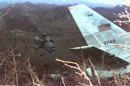
USAF MH-53J Pave Low helicopter near the wreckage of the USAF CT-43A approximately 3 kilometers north of the Dubrovnik Airport in Croatia, April 4, 1996.Accident summary Date April 3, 1996 Type Pilot error, badly designed instrument approach, CFIT Site 3 kilometers north of Čilipi Airport Passengers 30 Crew 5 Fatalities 35 (all) Aircraft type Boeing CT-43 (a modified version of the Boeing 737-200) Operator United States Air Force Tail number 73-1149[1] Flight origin Zagreb International Airport, Zagreb, Croatia Last stopover Tuzla International Airport, Tuzla, Bosnia-Herzegovina Destination Čilipi Airport, Dubrovnik, Croatia 
 Zagreb Pleso AirportTuzla Airport
 Dubrovnik Čilipi Airport
 Crash Site St John's HillLocation of crash site and departure and destination airports
On April 3, 1996, a United States Air Force CT-43A crashed on approach to Dubrovnik, Croatia while on an official trade mission. The aircraft, a Boeing 737-253 built as a T-43 navigation trainer, was carrying United States Secretary of Commerce Ron Brown and 34 other people, including The New York Times Frankfurt Bureau chief Nathaniel C. Nash. While attempting an instrument approach to Dubrovnik Airport, the airplane crashed into a mountainside killing everyone on board. Air Force Tech. Sgt Shelly Kelly initially survived the impact of the crash but died from her injuries hours later in an ambulance.[2]
The aircraft was operated by the 86th Airlift Wing, based at Ramstein Air Base in Germany. Unlike civilian 737s, the military CT-43A version was equipped with neither a flight data recorder nor a cockpit voice recorder.[3]
Crash details
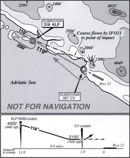
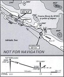 Summary of the NDB approach to runway 12 from the USAF accident report
The official Air Force accident investigation board report noted several reasons that led the CT-43, callsign IFO-21 (short for Implementation Force),[4] to crash. Chief among the findings was a "failure of command, aircrew error and an improperly designed instrument approach procedure". Notably the inclement weather[5] was not deemed a substantial contributing factor in the crash.
The CT-43A used for this flight had formerly been a training aircraft that had been converted for distinguished visitor travel. The flight had been on an IFR NDB approach, which is a non-precision type of instrument approach, to Runway 12 when it strayed off course. Non-precision approaches are those that do not incorporate vertical guidance.[6] While NDB approaches are essentially obsolete in the U.S. they are still used widely in other parts of the world. Because of their infrequent use in the U.S. many American pilots are not fully proficient in performing them (a NASA survey showed that 60% of U.S. transport-rated pilots had not flown an NDB approach in the last year).[3] The investigation board determined that the approach used was not approved for Department of Defense aircraft, and should not have been used by the aircraft crew.[7] The board determined that the particular NDB approach used required two operating ADF, the instrument used to fly such an approach, on board the aircraft, but this aircraft only had one. One was required to track the outbound course of 119° from the Kolocep NDB (KLP). Another was required to observe when the aircraft had flown beyond the Cavtat NDB (CV) which marked the missed approach point. Further, the board noted that the approach was rushed, with the aircraft flying at 80 knots (150 km/h) above the proper final approach speed, and had not received the proper landing clearance from the control tower.[7]
The crash site, on a 2,300 ft (701 m) hill, was 1.6 miles (2.6 km) northeast of where the aircraft should have been on the inbound course to the NDB. The published NDB approach brings the inbound aircraft down a valley, and has a minimum descent height of 2,150 feet (655 m) at the missed approach point (where they should have climbed and turned to the right if the runway was not in view), which is below the elevation of the hills to the north. The runway is at 510 feet (155.4 m) MSL. Five other aircraft had landed prior to the CT-43A and had not experienced any problems with the navigational aids. There was no emergency call from the pilots, and they did not initiate a missed approach, even though they were beyond the missed approach point when they hit the hill at 2:57 PM local time.[3][4]
The area of the crash site is identified by a large (10 meter tall) stainless steel cross on Stražišće peak. Hikers can reach the peak via the Ronald Brown path which is named in commemoration of the U.S. Secretary of Commerce who died in the crash.[8] It is not unusual for hikers to find military aircraft remnants from the crash.[citation needed]
The crash is featured on the 4th series the air crash investigation show Mayday, entitled Fog of War.
References
- ^ Boeing737.org T-43A page. Retrieved: 29 November 2008
- ^ "Flight 21 is Missing," Mayday
- ^ a b c Hughes, David "USAF, NTSB, Croatia Probe 737 Crash", Aviation Week & Space Technology, 8 April 1996
- ^ a b Transcript of US Department of Defense News briefing held on 7 June 2006 "Results of the Accident Investigation Report of the CT-43 Accident". Retrieved: 29 November 2008
- ^ "The weather at the time of the approach was reported as 400 feet broken, 2,000 feet overcast, 8 km or about 5 miles visibility, rain, surface winds for 120, 12 knots, because of the weather, the crew is required to fly an instrument approach procedure into Dubrovnik." Transcript of US Department of Defense News briefing held on 7 June 2006 "Results of the Accident Investigation Report of the CT-43 Accident". Retrieved: 29 November 2008
- ^ FSF ALAR Briefing Note 7.2 - Constant Angle Nonprecision Approach Flight Safety Foundation
- ^ a b DoD news release Archived May 30, 2010 at the Wayback Machine
- ^ Dubrovnik Online website Retrieved: 17 October 2009
References
- USAF accident report
- Walters, James M. and Sumwalt, Robert L. III, Aircraft Accident Analysis: Final Reports (McGraw Hill 2000).
← 1995 · Aviation accidents and incidents in 1996 · 1997 → Aug 03 1995 – Aug 16 1996 Airstan incident
Jan 08 Air Africa crash
Feb 06 Birgenair Flight 301
Feb 29 Faucett Flight 251
Apr 03 USAF CT-43 crash
May 11 ValuJet Flight 592
Jun 09 Eastwind Airlines Flight 517Jun 13 Garuda Indonesia Flight 865
Jul 06 Delta Air Lines Flight 1288
Jul 15 Herculesramp
Jul 17 TWA Flight 800
Aug 19 Spair Airlines Flight PAR-3601
Aug 29 Vnukovo Airlines Flight 2801Oct 02 Aeroperú Flight 603
Oct 31 TAM Airlines TAR Flight 402
Nov 12 Charkhi Dadri mid-air collision
Nov 19 United Express Flight 5925
Nov 23 Ethiopian Airlines Flight 961
Dec 24 New Hampshire Learjet crashIncidents resulting in at least 50 deaths shown in italics. Deadliest incident shown in bold smallcaps.Coordinates: 42°35′53.78″N 18°15′7.14″E / 42.5982722°N 18.2519833°E
Categories:- Accidents and incidents involving controlled flight into terrain
- Aviation accidents and incidents in 1996
- Aviation accidents and incidents in Croatia
- Non-combat military accidents
- Accidents and incidents involving United States Air Force aircraft
- Accidents and incidents involving the Boeing 737
- Aviation accidents and incidents involving state leaders


Wikimedia Foundation. 2010.