- Moura, Queensland
-
Moura
Queensland
 Moura
MouraPopulation: 1,774 (2006 Census)[1] Postcode: 4718 Location: - 589 km (366 mi) from Brisbane
- 171 km (106 mi) from Rockhampton
LGA: Banana Shire State District: Callide Federal Division: Flynn Mean max temp Mean min temp Annual rainfall 32 °C
90 °F12 °C
54 °F732 mm
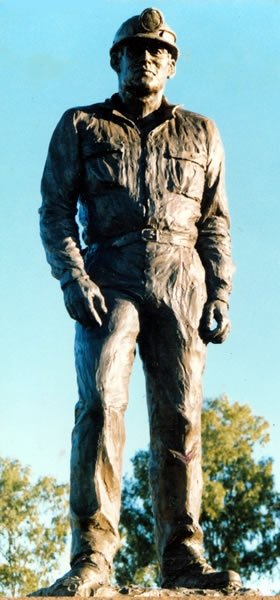
28.8 in Sculpted by Diana Webber, this bronze statue was erected in 1988 to commemorate the Moura mine disasters.
Moura is a small town servicing the surrounding coal mining and rural activities. The town was first established in 1936 as a farming centre near the existing Moura Station.
The town of Moura is located in Central Queensland, Australia. It is situated approximately 65 kilometres west of Biloela on the Dawson Highway, 186 kilometres west of the port city of Gladstone, and 171 kilometres south west of Rockhampton and is administered by the Banana Shire Council. At the 2006 census, Moura had a population of 1,774.[1]
The town also has many shops, including banks, post office, video store, grocery store, newsagent, beauticians, hairdressers, butcher, service station, electrical, furniture and hardware store and many more. Moura also has numerous sporting clubs (golf, bowls, squash, football) as well as eateries and restaurants. There is also a RSL and Memorial (now closed) club for socialising.
A number of industries are represented in the local economy. Chief amongst these is coal mining. The name of the local coal mine changes each time it's sold - currently Dawson Mine - owned and operated by Anglo Coal. Only open-cut mining has been used since 1994.
There have been three mining disasters that have occurred near Moura:
- The first was the Kianga mining disaster occurring due to an explosion in the underground workings of the Kianga No. 1 mine on 20 September 1975, claiming 13 miners' lives.[2]
- The second, on 16 July 1986, was an explosion in the Moura No. 4 underground mine, claiming twelve miners' lives, the youngest miner being 18.[3]
- The third was an explosion in the Moura No. 2 underground coal mine on 7 August 1994. Rescue and recovery attempts were abandoned after a second, more violent explosion occurred 18 hours later. Eleven miners' lives had been lost and the mine was sealed at the surface.[4]
After 1994, underground mining ceased and the area was operated as an open-cut coal mine.
The references in the text above have been moved but the full reports of these accidents can still be found at this reference.[5] There is also a book titled "Managing Major Hazards - The Lessons of the Moura Mine Disaster" which was written by Andrew Hopkins.
Beef, cotton and cereals are other major industries of the area.
Average yearly Rainfall: 732mm, raining an average of 63 days per year. The average summer temperature is 32 degrees Celsius (with temperatures in excess of 36 degrees Celsius a common occurrence during Dec-Jan). The average winter temperature is 12 degrees Celsius.
Contents
History
In 1854 Charles Marshall named the local property Moura after Moura in Portugal where he served in the British Army during the Peninsular Wars. This land was developed into a homestead in 1880 by Edward Homer.
Education
Preschool
Primary School
Moura State School was opened in 1940.
High School
Moura State High School was opened in 1976.
Attractions
150th meridian
The 150th meridian east, located just outside of Moura, is a very popular among tourists as well as local residents to have their picture taken in the exact path of the longitude line. Rocks with drill holes have been lined up to represent the exact angle and location of longitude line.
APEX Park (river)
The APEX park is situated next to the Dawson River which is located 7 km west on the Dawson highway. The APEX park has free camping grounds with facilities such as hot showers, a traditional wood barbecue, toilets and lawn for the afternoon picnic. It also has a public boat ramp.
Museum
Culture, Events and Festivals
Muddy Water Classic
Moura Muddy water classic is held in February at the APEX park and brings many people from the surrounding areas for the local fishing competition.
Coal and Country Festival
Coal and Country festival held every year in the third week of August every year for seven days. The festival holds events like coal shovelling and skydiving.
References
- ^ a b Australian Bureau of Statistics (25 October 2007). "Moura (Urban Centre/Locality)". 2006 Census QuickStats. http://www.censusdata.abs.gov.au/ABSNavigation/prenav/LocationSearch?collection=Census&period=2006&areacode=UCL342200&producttype=QuickStats&breadcrumb=PL&action=401. Retrieved 13 June 2011.
- ^ Full report - Kianga No 1 underground mine, warden's inquiry
- ^ Full report - Moura No 4 underground mine, warden's inquiry
- ^ Full report - Moura No 2 underground mine, warden's inquiry
- ^ Moura Disaster Reports
External links
- University of Queensland: Queensland Places: Moura
- Mining town casts its memories in Bronze The Australian 19 October 1987
- Bronze reminder of a disaster The Sydney Morning Herald 8 April 1988
- As Moura mourns the loss of 11 miners, a colleague reveals how he cheated death New Idea, 1994
- Moura Chamber of Commerce Community Web Site
Towns in the Banana Shire Local Government Area Main Article: Local Government Areas of QueenslandCategories:- Towns in Queensland
- Mining towns in Queensland
- Coal mining disasters in Australia

Wikimedia Foundation. 2010.