- Dunedin Southern Motorway
-
Dunedin Southern Motorway
State Highway 1 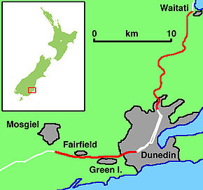
Dunedin Northern and Southern Motorways (marked in red - other parts of State Highway 1 are marked in white)Route information Maintained by New Zealand Transport Agency Length: 11 km (7 mi) Existed: 1972 – present Major junctions Northeast end: Lookout Point, Dunedin State Highway 87 Southwest end: Mosgiel Location Primary
destinations:Dunedin, Green Island, Fairfield, Mosgiel Highway system New Zealand State Highways
Motorways and Expressways • List • UnusedThe Dunedin Southern Motorway is the main arterial route south from the South Island city of Dunedin, part of New Zealand's State Highway 1. It is one of the world's southernmost motorways.
Contents
Route
SH1 traverses Dunedin as two multiple-lane one-way streets, travelling past the University of Otago and the CBD before rejoining as a single multiple-lane road at the Andersons Bay intersection; a busy signal-controlled "T" intersection with SH1 and Andersons Bay Road in South Dunedin.
From the intersection SH1 becomes a four lane median-divided road for 700 metres, crossing King Edward Street (South Dunedin's main street) on twin overbridges at Kensington, until near the Glen, just north of Carisbrook, where it narrows to a two-lane undivided road. The southbound lanes merge into one, while the northbound carriageway gains a lane from the South Road on-ramp. While this section meets most technical definitions of a motorway with full limited access including no pedestrian or cycle traffic, it is not designated a motorway by the NZ Transport Agency due to its short length.
SH1 continues south as a two-lane limited-access road past Carisbrook and Caversham. The Main South Line parallels SH1 along the east side of the road. Known as the Caversham bypass, this section is subject to congestion during the morning and afternoon weekday peaks, being a bottleneck between the four-lane sections of SH1 immediately to the north and south.
From Andersons Bay to Barnes Drive, at the south end of Caversham, SH1 has an 80 km/h speed limit.
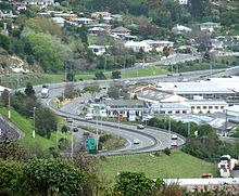
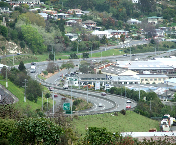
At the base of Calton Hill, SH1 intersects with Barnes Drive at a signal-controlled intersection. Here SH1 becomes a four-lane road before climbing over Calton Hill to Lookout Point. This section is residential arterial road with houses upon both sides and a 50 km/h speed limit enforced by a fixed speed camera about one third of the way up the hill. There are proposals to widen this road to connect the Caversham bypass with the motorway to the south.
Near the crest of Lookout Point, SH1 retains priority through an off-set intersection with Mornington Road and South Road, before heading southwards over the crest. At this point the motorway begins, with a concrete median divider and an increase in the speed limit to 100 km/h.
The motorway winds relatively steeply down past the site of the former Burnside Freezing Works, and crosses the Main South Road/Kaikorai Valley Road interchange on a bridge.
Once on the flat of the Kaikorai Valley the motorway passes underneath the northbound on-ramp from Green Island before passing between the suburbs of Green Island and Abbotsford to the Green Island/Sunnyvale interchange.
Beyond this interchange the motorway crosses the Kaikorai Estuary and bisects the suburb of Fairfield. There is a half diamond interchange at Old Brighton Road (northbound on, southbound off) before the motorway climbs towards its highest point, crossing a ridge of Saddle Hill. (A new overbridge was constructed to take Old Brighton Rd over the new motorway. This was named after W.G (Bill) Auld MBE, a local resident and dignatory who was a staunch advocate for the motorway bypassing Fairfield. He died shortly before the completion of the motorway but on the day of his funeral was 'driven' down the route he fought hard to implement.) There is another half-diamond interchange (northbound off, southbound on) and a separate overbridge for Morris Road.
The motorway then descends from the slopes of Saddle Hill onto the floodplain of the Taieri River at Mosgiel. There is a full diamond interchange with SH 87, the primary access to Mosgiel from SH1. At this point the motorway narrows to a two-lane undivided road. The motorway designation continues for a further 600 metres before continuing through the suburb of East Taieri.
History
A motorway extending south from the Andersons Bay intersection was first proposed from the late 1950s, when Dunedin, like other major centres in New Zealand, was experiencing rapid vehicle growth and a decline in public transport usage.[1]
A report from De Leuw Cather was commissioned by the Dunedin City Council in 1963, which recommended a number of changes primarily to Dunedin's arterial road system. A number of roads around the city were widened to four lanes, and the report recommended that investigation, design, and construction begin of the proposed southern motorway.
During this time period the then Ministry of Works designated a substantial amount of land for future upgrade works along SH1, with a view that by the late 1990s much of it would be rebuilt as motorway, possibly along the lines of a US Interstate, with bypasses of all small towns, grade separation of all intersections, and no private property accesses. Within the Dunedin area, Council planning maps from the 1960s and 1970s show a designation for a "Dunedin to Milton Motorway" which is part of these Ministry of Works designations.
The present constructed motorway generally follows along the route of this early designation. Further evidence of the Ministry of Works intentions can be seen on the "flood-free" section of SH1 near Henley on the Taieri Plains, 35 km south of Dunedin, where the two-lane road has a 2.5-metre shoulder on the northbound side and a standard 0.5-metre shoulder on the southbound. This two-lane road was constructed in the early 1970s as the northbound lanes of a motorway, with the intention that separate southbound lanes would be constructed in the future.
Section-by-section construction
 The Dunedin Southern Motorway snakes its way south past Burnside and Green Island
The motorway was constructed in a number of sections.
The first section was completed in 1972 and bypassed the suburb of Green Island.This section began at the southern end of Kaikorai Valley Road at Burnside, and travelled south for 2.5 kilometres, dividing Green Island from Abbotsford. It ended at the southern end of Green Island, and connected with the main south road through Fairfield. Construction of this section of motorway is considered by some people to have been a causal factor of the Abbotsford Landslide in 1979. Around the same time, construction began on the section traversing Saddle Hill, from Mosgiel to Fairfield. Earthworks were undertaken to allow for the construction of a four-lane motorway with northbound and southbound slip lanes extending from a future interchange with SH87 at Mosgiel. At the time the road was constructed with two lanes and a northbound passing lane northward from the SH1/SH87 intersection.
The second section was a short 700-metre section of four-lane dual carriageway completed in 1978. It extended southwards from the Andersons Bay intersection, across King Edward Street on twin bridges to connect with South Road near the Glen.
The 1980s saw the extension of the motorway south from the Glen to Barnes Drive, bypassing Caversham. Due to funding constraints this section was only built as a single two-lane carriageway, albeit with no intersections.
SH1 from Barnes Drive to Lookout Point was upgraded with the addition of a second northbound lane, giving four lanes in total. Aberfeldy Street was limited to a left in/left out intersection.
In 1987, due to high accident and congestion problems, the at-grade intersection with SH87 at Mosgiel was upgraded into a full diamond interchange. Under severe funding constraints the SH87 bridge was built to accommodate only two lanes of SH1 travelling underneath, which will make widening of SH1 at this point more costly.
In 1989-1990 the Green Island motorway was extended northwards up Calton Hill past the Burnside Freezing Works to re-connect with SH1 at Lookout Point.
A major extension was completed in 2003 when the 4.5-km Fairfield Bypass was opened. This connected the southern terminus of the Green Island Motorway with the northern end of the Saddle Hill section of SH1. There were several delays in construction of this stretch due to the presence of mine workings that created major difficulties in the stabilisation of the land along the route. The Saddle Hill section was upgraded at this time to a four-lane divided motorway to take advantage of the preparatory earthworks completed in the 1960s.
The completion of the Fairfield section meant that SH1 was now an uninterrupted four-lane divided motorway from Lookout Point to the SH87 interchange. As of 2010[update] construction is underway to widen the northbound route immediately north of the Saddle Hill saddle.
Future works
Caversham Bypass
The NZ Transport Agency began upgrading SH1 from the Andersons Bay intersection to Lookout Point to a four-lane dual carriageway in January 2011.[1]
East Taieri Bypass
Land was designated in the early 1960s by the then Ministry of Works for a motorway corridor from the SH1/SH87 interchange southwards through East Taieri towards Allanton. This would have re-aligned SH1 along this route and have extended the motorway southwards for several kilometres beyond its present terminus. A stretch of SH1 was realigned in this area during the 1970s, moved westward to avoid the edge of the coastal range of hills, and the junction with SH86 at Allanton was redesigned, but no further work towards a potential motorway extension was carried out. Transit New Zealand did not seek to renew the designation for this road in 2007 [2], meaning that this project is now unlikely to proceed.
Junction list
Territorial authority Location km Destination Notes Dunedin City  SH 1 Andersons Bay Road (north) – City Centre, Timaru
Andersons Bay Road (south) – South Dunedin, Andersons Bay, Otago Peninsula, bypass northTraffic light controlled intersection
Dunedin Southern Motorway begins'Caversham  Southern Scenic Route Barnes Drive
Caversham, South Dunedin, CarisbrookTraffic light controlled intersection Burnett Street Aberfeldy Street Lookout Point South Road – Corstorphine Mornington Road – Mornington Main South Road – Concord, Burnside Southbound exit and northbound entrance
Motorway designation beginsBurnside Main South Road – Kaikorai Valley, Concord, Green Island Northbound exit and southbound entrance Green Island Main South Road – Green Island, Abbotsford Southbound exit only Sunnyvale Main South Road – Abbotsford, Brighton, Green Island Fairfield Old Brighton Road – Fairfield, Saddle Hill Southbound exit and northbound entrance Saddle Hill Road – Fairfield, Saddle Hill Northbound exit and southbound entrance  SH 87 Quarry Road – Mosgiel
Braeside Dunedin Southern Motorway and motorway designation end SH 1– Airport, InvercargillSee also
- List of motorways in New Zealand
References
- ^ Oldham, Stu (19 January 2011). "Work starts on multimillion-dollar upgrade". Otago Daily Times. http://www.odt.co.nz/news/dunedin/144691/work-starts-multimillion-dollar-upgrade. Retrieved 29 September 2011.
List of motorways and expressways in New Zealand Auckland Northern Motorway · Northwestern Motorway · Southern Motorway · Southwestern Motorway · Upper Harbour MotorwayWellington Rest of North Island South Island Christchurch Northern Motorway · Christchurch Southern Motorway · Christchurch-Lyttelton Motorway · Dunedin-Waitati Highway · Dunedin Southern MotorwayPast motorways/expressways Future motorways/expressways Penlink · Waterview Connection · Transmission Gully Motorway · Kapiti Expressway · Tauranga Eastern Motorway · Christchurch Southern MotorwayMajor infrastructure Categories:- Motorways in New Zealand
- Transport in Dunedin
- Two-lane motorways


Wikimedia Foundation. 2010.