- Cenad
-
Cenad — Commune — 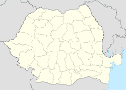
 Cenad
CenadCoordinates: 46°8′N 20°35′E / 46.133°N 20.583°E Country  Romania
County Timiş County Population (2002)[1] 4,249 Time zone EET (UTC+2) – Summer (DST) EEST (UTC+3) Cenad (Hungarian: Csanád; Serbian: Чанад) is a commune in Timiş County, Banat, Romania. It is composed of a single village, Cenad.
Demography
Census[1] Ethnicities Year Population Romanians Germans Hungarians Serbs Gypsies Others 1880 6,982 2,074 3,166 128 1,495 - 6 1900 7,389 2,246 3,244 211 1,583 - 1 1930 7,236 2,120 2,985 655 1,216 227 22 1977 5,022 2,023 1,419 682 654 229 10 1992 3,991 2,304 83 734 401 450 18 2002 4,263 2,812 48 677 266 371 89 Coordinates: 46°08′N 20°35′E / 46.133°N 20.583°E
References
- ^ Romanian census data, 2002; retrieved on March 1, 2010
Categories:- Communes in Timiş County
- Hungary–Romania border crossings

Wikimedia Foundation. 2010.