- N'guigmi
-
N'guigmi
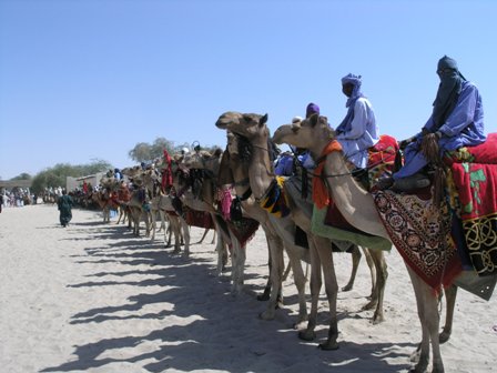
Nguigmi, NgigmiCamel riders line up outside the residence of the traditional chief of Nguigmi Location of N'guigmi
 N'guigmi
Coordinates: 14°15′10″N 13°06′39″E / 14.25278°N 13.11083°ECoordinates: 14°15′10″N 13°06′39″E / 14.25278°N 13.11083°E Country Niger Region Diffa Region Department N'guigmi Department Commune Nguigmi Elevation 297 m (977 ft) Population (2001 census)[1] – Total 15,922 [2]  Metric temperature & rainfall diagram for N'guigmi (in German). Shows average daytime high of 27.5 degrees Celsius, total yearly rainfall average of 212 millimeters.
N'guigmi is a city and Commune of fifteen thousand in the eastern most part of Niger, very near to Lake Chad - lying on its shore until the lake retreated.
N'guigmi is a military center for the region, a centre for the salt trade from Kaourar and is the last stop on the road to Chad. It marks the end of the paved section of the Nigerien Route Nationale 1, although the sections past Diffa are notorious for their poor condition.[3] Three unpaved highways connect to N'guigmi from the north, providing the main road route between Chad and Niger, and another one of two land routes to the Kaourar Oasis town of Bilma.
The town lies at the mouth of the Dilia Bosso, an ancient river valley and seasonal wash that runs from the Termit Massif over 200 km to the northwest to what was the shore of Lake Chad as recently as the mid 20th century. The town was then a centre of Kanuri fishing communities. By the 2000s, even during the rainy season, the nearest access to water was at the village of Doro (a Beri-beri name for "Fishing port") 45 km southwest of N'guigmi. During the Sahel drought of the mid-1970s the shore was 85 km away from N'guigmi in Chad.[4]
The town is the seat of the Department of N'guigmi, one of three in Diffa Region, which includes the entire north of the Region. N'guigmi is home to a large settlement of Kanuri people, as well as settled members of the traditionally pastoral Wodaabe-Fulani and Daza/Toubou ethnic groups.
References
- ^ Population figures from citypopulation.de, citing (2001) Institut National de la Statistique du Niger.
- ^ Nguigmi, Niger Page. Falling Rain Genomics, Inc. 1996-2004
- ^ See Geels. 2005 photographs from a Dutch travel writer are posted here, and here
- ^ Geels (2006) pp.236-237
- Decalo, Samuel (1997). Historical Dictionary of the Niger (3rd ed.). Boston & Folkestone: Scarecrow Press. ISBN 0810831368.:p.225
- Geels, Jolijn (2006). Niger. Chalfont St Peter, Bucks / Guilford, CT: Bradt UK / Globe Pequot Press. ISBN 9781841621524.:pp.232-237
 Communes of NigerCapital: Niamey
Urban communes Abalak · Agadez · Aguie · Arlit · Bilma · Birni N'Gaoure · Birni N'Konni · Bouza · Dakoro · Diffa · Dogondoutchi · Dosso · Filingue · Gaya · Guidanroumdji · Goure · Illela · Keita · Kollo · Loga · Madaoua · Madarounfa · Magaria · Maine Soroa · Maradi I · Maradi II · Maradi III · Matamey · Mayahi · Mirriah · N'Guigmi · Commune I (Niamey) · Commune II (Niamey) · Commune III (Niamey) · Commune IV (Niamey) · Commune V (Niamey) · Ouallam · Say · Tahoua I · Tahoua II · Tanout · Tchintabaraden · Tchirozerine · Tessaoua · Téra · Tibiri · Tillaberi · Zinder I · Zinder II · Zinder III · Zinder IV · Zinder VRural communes Abala · Aderbissinat · Adjekoria · Affala · Akoubounou · Albarkaram · Alakoss · Allakaye · Allela · Anzourou · Attantane · Ayerou · Azagor · Azarori · Azeye · Babankatami · Badaguichiri · Bader Goula · Bagaroua · Bambeye · Bana · Bande · Bangui · Banibangou · Bankilare · Baoudetta · Barmou · Bazaga · Bengou · Bermo · Bibiyergou · Birni Lalle · Bitinkodji · Bosso · Boune · Chadakori · Chetimari · Dabaga · Dakoussa · Damagaram Takaya · Dan-Barto · Dan-Goulbi · Dan-Issa · Dan-Kassari · Dannet · Dantchiao · Daouche · Dargol · Deoule · Dessa · Diagourou · Diantchandou · Dingazi · Dirkou · Dioundiou · Djado · Djiratawa · Dogo · Dogo-Dogo · Dogonkiria · Doguerawa · Doumega · Doungou · Droum · Dungass · El Allassane Maireyrey · Fabidji · Fachi · Fakara · Falenko · Falmey · Falwel · Farey · Foulatari · Gabi · Gababedji · Gaffati · Galma Koudawatche · Gamou · Gangara · Gangara · Garagoumsa · Garhanga · Garankedey · Gazaoua · Golle · Goroubankassam · Gorouol · Gothèye · Gouchi · Goudoumaria · Gougaram · Gouna · Guecheme · Gueskerou · Guidan Amoumoune · Guidan Sori · Guidiguir · Guidimouni · Guilladje · Hamdallaye · Hamdara · Harikanassou · Hawandawaki · Ibrohamane · Ichirnawa · Ifernouane · Imanan · Inates · Ingall · Issawane · Kablewa · Kao · Kalfou · Kanan-Bakache · Kankandi · Kantche · Karakara · Kargiubangou · Karma · Karofane · Kelle · Kieche · Kiota · Kirtachi · Kokorou · Kolleram · Koona · Korahane · Kore Mairoua · Korgom · Kornaka · Kouré · Kourfeye · Kourni · Kourteye · Koygolo · Kwaya · Libore · Maijirgiu · Maiyara · Malawa · Malbaza · Matankari · Mehana · Moa · Mokko · N'Dounga · N'Gonga · N'Gourti · N'Guelbely · Namaro · Ollelewa · Ourafane · Ouro Gueladjo · Ourno · Roumboui · Sabon-Guida · Sabon-Machi · Sae Saboua · Safo · Sakoira · Sambera · Sanam · Sarkin Haoussa · Sarkin Yamma · Sassoumbroum · Simiri · Sinder · Sokorbe · Soucoucoutane · Tabalak · Tabelot · Tabotaki · Tagazar · Tagriss · Tajae · Takanamat · Tama · Tamaske · Tamaya · Tamou · Tanda · Tarka · Tassara · Tchadoua · Tchake · Tebaram · Tenhya · Tesker · Tessa · Tibiri (Doutchi) · Timia · Tillia · Tirmini · Tombokoirey I · Tombokoirey II · Tondikandia · Tondikiwindi · Torodi · Toumour · Tounounga · Tsaouni · Tsernaoua · Wacha · Wame · Yaouri · Yekoua · Yelou · YouriCategories:- Communes of Niger
- Populated places in Niger
- Lake Chad
- Niger geography stubs


Wikimedia Foundation. 2010.