- Mount Scott (Oklahoma)
-
For other uses, see Mount Scott (disambiguation).
Mount Scott 
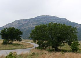
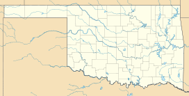
Mount Scott as seen from the east entrance to the Wichita Mountains National Wildlife Refuge.Elevation 2,464 ft (751 m) [1] Prominence 824 ft (251 m) [1] Location Mount Scott's location in Oklahoma. Location Comanche County, Oklahoma, USA Range Wichita Mountains Coordinates 34°44′40″N 98°31′55″W / 34.74444°N 98.53194°WCoordinates: 34°44′40″N 98°31′55″W / 34.74444°N 98.53194°W Geology Type Igneous[2] Age of rock Cambrian Period[2] Climbing Easiest route Drive Mount Scott is a prominent mountain just to the northwest of Lawton Oklahoma rising to a height of 2,464 feet (751 m) above sea level.[3] It is located in the Wichita Mountains near Fort Sill Military Reservation and lies in the Wichita Mountains National Wildlife Refuge. The US Fish and Wildlife Service is responsible for the maintenance of the area. Visitors can reach the summit by car or bicycle via a three-mile paved road. Hiking is allowed, although there are no formal trails and the paved road is closed to pedestrians. Mount Scott is also popular for its numerous rock climbing areas.
Geography
The Wichita Mountains National Wildlife Refuge is located in southwestern Oklahoma, just North of the city of Lawton and Fort Sill. The area is located near I-44, and is about 90 miles (145 km) from Oklahoma City. The Wildlife Refuge's proximity to Fort Sill means that the sound of artillery fire can often be heard by visitors and is sometimes mistaken for thunder.
Mount Scott is the second-highest mountain in the Wichita Mountains Wildlife Refuge, but it remains the most well-known and regularly visited. The 3+ mile paved road that winds from the base to the top of Mount Scott offers breath-taking views of the surrounding Oklahoma plains. Mt Pinchot lies several miles to the west and is the highest point in the Refuge being 12 feet taller. Mt Pinchot is located within the Wildlife Refuge's Special Use Area and is closed to the public.[3] From the west side of Mt Scott can be seen several prominent mountains to the west including Mt Sheridan, Elk Mountain, and Haley peak which lies just outside the NW corner of the WMWR. Haley Peak (officially unnamed) is the highest point in the Wichita Mountain range.
The Blue Canyon Wind Farm is north of Mount Scott, and the wind turbines are visible from the access road.
Routes
The easiest way to reach the summit is by car. A three-mile paved road is open during the day, and visitors can stop at any of several scenic pullouts located along the road. Parking is available at the top of the mountain.
Bicycles are allowed on the paved road leading to the summit of Mount Scott. Although the distance is fairly short, the ride is not recommended for beginners. The steep grades involved, heavy crosswinds, sharp turns, and automobile traffic could make the ride dangerous.
There are no hiking trails to the summit and large pedestrian groups are prohibited on the paved road. However, visitors are allowed to park at the base of the mountain and hike to a number of the rock climbing areas available on the mountain.
References
- ^ a b "Mount Scott, Oklahoma". Peakbagger.com. http://www.peakbagger.com/peak.aspx?pid=6349. Retrieved 2008-05-24.
- ^ a b "America's Volcanic Past: Oklahoma". US Geological Survey. http://vulcan.wr.usgs.gov/LivingWith/VolcanicPast/Places/volcanic_past_oklahoma.html. Retrieved 2008-05-24.
- ^ a b "Wichita Mountains Wildlife Refuge". US Fish and Wildlife Service. http://www.fws.gov/southwest/refuges/oklahoma/wichitamountains/faq.html#trails. Retrieved 2008-05-24.
Categories:- Geography of Comanche County, Oklahoma
- Mountains of Oklahoma
- Visitor attractions in Comanche County, Oklahoma
Wikimedia Foundation. 2010.

