- Neuenfelde
-
Neuenfelde Quarter of Hamburg View over the Elbe river to Neuenfelde Coordinates 53°30′53″N 9°47′44″E / 53.51472°N 9.79556°ECoordinates: 53°30′53″N 9°47′44″E / 53.51472°N 9.79556°E Administration Country Germany State Hamburg City Hamburg Borough Hamburg-Harburg Basic statistics Population 4,614 (31 December 2006) Other information Time zone CET/CEST (UTC+1/+2) Licence plate HH Area code 040 Neuenfelde is a rural quarter located in the borough Harburg of Hamburg, Germany near the Lower Saxony border. The quarter is well known for its quality of fruit and unique houses, many of which prove to be popular attractions for tourists passing through, it belongs to the Altes Land region and is quite known for the cherry and apple tree blossom. In 2006 the population was 4,614.
Contents
History
Neuenfelde as Nincop was first mentioned in 1257 as a village of Dutch settlers. In 1937 due to the Greater Hamburg Act Neuenfelde became a part of Hamburg.
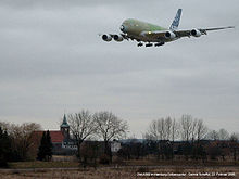
The survival of the settlement is currently under threat from the nearby Airbus factory and its airport. Over the past few years, Airbus extended their runway towards Neuenfelde. This upset local residents, many of whom have had to sell their properties in order to accommodate these plans. Another source of upset was the planned relocation of the local St. Pankratius church, home to a historic Baroque organ built by Arp Schnitger. On July 16, 2007 the new longer runway started operations.[1]
Geography
In 2006 according to the statistical office of Hamburg and Schleswig-Holstein, the quarter Neuenfelde has a total area of 15.5 km2 (6 sq mi). Neuenfelde is part of the region Altes Land.[2] The quarter borders in the North to the river Elbe and the Finkenwerder quarter of the borough of Hamburg-Mitte. In the West is the small quarter Cranz and the district of Stade of Lower Saxony In the south is the Neugraben-Fischbek quarter and the eastern bordern is to the quarter Francop. The settlement Neuenfelde consists of two main streets; Nincoper Straße and Arp-Schnitger-Steig, the latter populated by the majority of the town's commercial activity, notably a kindergarten, school, fire brigade, restaurant, pharmacy and a hair salon. Bordering the settlement is Hasselwerder Straße and Marschkamper Deich.
Demographics
In 2006 in the quarter Neuenfelde were living 4,614 people. The population density was 298 inhabitants per square kilometre (772 /sq mi). 22.2% were children under the age of 18, and 14.9% were 65 years of age or older. 25.3% were resident alliens. 199 people were registered as unemployed.[3]
In 1999 there were 2,026 households and 26.5% of all households were made up of individuals.[4]
There were 1 elementary school and no secondary school in the quarter Neuenfelde and 2 physicians in private practice and no pharmacy.[5]
Transportation
The quarter is not serviced by the rapid transit system of S- or U-Bahn, however public transport to the city is provided by the bus no. 257 direction Neugraben, as well as the bus no. 150 direction Altona. According to the Department of Motor Vehicles (Kraftfahrt-Bundesamt), in the quarter Neuenfelde were 2,001 private cars registered (429 cars/1000 people).[5]
Notable buildings
- St. Pankratius-Kirche, local church
Notable persons
- Arp Schnitger (1648 - 1719), German organ builder
Notes
- ^ http://www.rege-hamburg.de/templates/pressetemplate.php?presseid=57 press information release ReGe Hamburg Projekt-Realisierungsgesellschaft mbH (in German)
- ^ "Altländer ABC". 900jahreneuenfelde.de. http://www.900jahreneuenfelde.de/content/drumherum/abc.html. Retrieved 2008-10-01. (German)
- ^ Residents registration office, source: statistical office of Hamburg and Schleswig-Holstein (2006)
- ^ Source: statistical office of Hamburg and Schleswig-Holstein (1999)
- ^ a b Source: statistical office of Hamburg and Schleswig-Holstein (2006)
References
- Statistical office Hamburg and Schleswig-Holstein Statistisches Amt für Hamburg und Schleswig-Holstein, official website (in German)
External links
- 3 Meilen vor Hamburg - official web site of the Altes Land tourism association. Retrieved on 1 October 2008.
Free and Hanseatic city of Hamburg (Freie und Hansestadt Hamburg) Government and symbols Culture and economy Lists Castles · Churches · Museums and cultural institutions · Honorary citizens · Diplomatic missions · MayorsSee also: Hamburg Metropolitan Region Boroughs and quarters of the Free and Hanseatic City of Hamburg Boroughs Altona · Bergedorf · Eimsbüttel · Hamburg-Mitte · Hamburg-Nord · Harburg · Wandsbek
Quarters Allermöhe · Alsterdorf · Altengamme · Altenwerder · Altona-Altstadt · Altona-Nord · Bahrenfeld · Barmbek-Nord · Barmbek-Süd · Bergedorf · Bergstedt · Billbrook · Billwerder · Billstedt · Blankenese · Borgfelde · Bramfeld · Cranz · Curslack · Dulsberg · Duvenstedt · Eidelstedt · Eilbek · Eimsbüttel · Eißendorf · Eppendorf · Farmsen-Berne · Finkenwerder · Francop · Fuhlsbüttel · Groß Borstel · Groß Flottbek · Gut Moor · HafenCity · Hamburg-Altstadt · Hamm-Mitte · Hamm-Nord · Hamm-Süd · Hammerbrook · Harburg · Harvestehude · Hausbruch · Heimfeld · Hoheluft-Ost · Hoheluft-West · Hohenfelde · Horn · Hummelsbüttel · Iserbrook · Jenfeld · Kirchwerder · Kleiner Grasbrook · Langenbek · Langenhorn · Lemsahl-Mellingstedt · Lohbrügge · Lokstedt · Lurup · Marienthal · Marmstorf · Moorburg · Moorfleet · Neuenfelde · Neuengamme · Neugraben-Fischbek · Neuland · Neustadt · Neuwerk · Niendorf · Nienstedten · Ochsenwerder · Ohlsdorf · Osdorf · Othmarschen · Ottensen · Poppenbüttel · Rahlstedt · Reitbrook · Rissen · Rönneburg · Rothenburgsort · Rotherbaum · Sasel · Schnelsen · Sinstorf · Spadenland · St. Georg · St. Pauli · Steilshoop · Steinwerder · Stellingen · Sternschanze · Sülldorf · Tatenberg · Tonndorf · Uhlenhorst · Veddel · Volksdorf · Wandsbek · Waltershof · Wellingsbüttel · Wilhelmsburg · Wilstorf · Winterhude · Wohldorf-Ohlstedt
Categories:- Quarters of Hamburg
Wikimedia Foundation. 2010.


