- Oberleichtersbach
-
Oberleichtersbach 

 OberleichtersbachLocation of Oberleichtersbach within Bad Kissingen district
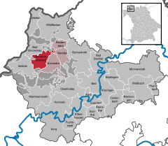
Coordinates 50°17′N 9°48′E / 50.28333°N 9.8°ECoordinates: 50°17′N 9°48′E / 50.28333°N 9.8°E Administration Country Germany State Bavaria Admin. region Lower Franconia District Bad Kissingen Municipal assoc. Bad Brückenau Local subdivisions 5 Ortsteile Mayor Walter Müller (CSU/ Freie Christl. Wählergr.) Basic statistics Area 27.60 km2 (10.66 sq mi) Elevation 408 m (1339 ft) Population 2,050 (31 December 2010)[1] - Density 74 /km2 (192 /sq mi) Other information Time zone CET/CEST (UTC+1/+2) Licence plate KG Postal code 97789 Area code 09741 Website www.Oberleichtersbach.de Oberleichtersbach is a municipality in the district of Bad Kissingen in Bavaria in Germany.
Contents
Divisions of the municipality
The municipality includes the following towns:
- Oberleichtersbach
- Unterleichtersbach
- Modlos
- Breitenbach
- Mitgenfeld
History
Motten originally belonged to the Bishop of Fulda, and was secularized in 1803 and given to Archduke Ferdinand of Orange. In 1806, it became part of the Province of Fulde in France. In the Congress of Vienna in 1815, it was given to Austria. Since 1818, it has belonged to Bavaria.
Population
Year Population 1970 1653 1987 1787 2000 2046 2005 2114 Coat of arms
Quartered with 1 and 4 in silver with a cross; 2 and 3 divided diagonally gold and red.
Economy
As of 1998, there were 428 businesses in the municipality. As of 1999, there were 84 agricultural businesses, with 2091 ha under cultivation, 788 ha in fields, and 1296 ha in pasture.
External links
References
- ^ "Fortschreibung des Bevölkerungsstandes" (in German). Bayerisches Landesamt für Statistik und Datenverarbeitung. 31 December 2010. https://www.statistikdaten.bayern.de/genesis/online?language=de&sequenz=tabelleErgebnis&selectionname=12411-009r&sachmerkmal=QUASTI&sachschluessel=SQUART04&startjahr=2010&endjahr=2010.
- This article incorporates information from the German Wikipedia.
Aura | Bad Bocklet | Bad Brückenau | Bad Kissingen | Burkardroth | Elfershausen | Euerdorf | Fuchsstadt | Geroda | Hammelburg | Maßbach | Motten | Münnerstadt | Nüdlingen | Oberleichtersbach | Oberthulba | Oerlenbach | Ramsthal | Rannungen | Riedenberg | Schondra | Sulzthal | Thundorf | Wartmannsroth | Wildflecken | Zeitlofs Categories:
- Municipalities in Bavaria
- Bad Kissingen district


Wikimedia Foundation. 2010.