- Oberthulba
-
Oberthulba 

 OberthulbaLocation of Oberthulba within Bad Kissingen district
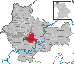
Coordinates 50°12′N 9°58′E / 50.2°N 9.96667°ECoordinates: 50°12′N 9°58′E / 50.2°N 9.96667°E Administration Country Germany State Bavaria Admin. region Lower Franconia District Bad Kissingen Local subdivisions 8 Ortsteile Mayor Gotthard Schlereth (Freie Wählergemeinschaft) Basic statistics Area 52.24 km2 (20.17 sq mi) Elevation 270 m (886 ft) Population 5,056 (31 December 2010)[1] - Density 97 /km2 (251 /sq mi) Other information Time zone CET/CEST (UTC+1/+2) Licence plate KG Postal code 97723 Area code 09736 Website www.oberthulba.de Oberthulba is a municipality in the district of Bad Kissingen in Bavaria in Germany.
Contents
Divisions of the municipality
- Oberthulba
- Frankenbrunn
- Hassenbach
- Hetzlos
- Reith
- Schlimpfhof
- Thulba
- Wittershausen
History
With secularization of the government in 1803, the territory of the present municipality became part of Bavaria. In the Treaty of Pressburg between France and Austria in 1805, the lands of the Bishop of Würzburg were given to Ferdinand III, Grand Duke of Tuscany, and he was made Grand Duke of Würzburg, a new state, as a reward for his support of Napoleon. These lands then again became part of Bavaria in 1814 (this time permanently) at the defeat of Napoleon.
Population
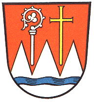
Year Population 1970 3717 1987 4261 2000 5121 2005 5177 Coat of arms
The upper half is red, and the lower half has three white peaks with a blue band of waves. On the left is a silver bishop's staff, and on the right a gold St. John's cross.
Economy
As of 1998, there were 545 businesses in the municipality. As of 1999, there were 108 agricultural businesses, with 2424 ha under cultivation, 1523 ha in fields, and 887 ha in pasture.
Notable residents
- Herbert Neder, politician (CSU)
External links
References
- ^ "Fortschreibung des Bevölkerungsstandes" (in German). Bayerisches Landesamt für Statistik und Datenverarbeitung. 31 December 2010. https://www.statistikdaten.bayern.de/genesis/online?language=de&sequenz=tabelleErgebnis&selectionname=12411-009r&sachmerkmal=QUASTI&sachschluessel=SQUART04&startjahr=2010&endjahr=2010.
- This article incorporates information from the German Wikipedia.
Aura | Bad Bocklet | Bad Brückenau | Bad Kissingen | Burkardroth | Elfershausen | Euerdorf | Fuchsstadt | Geroda | Hammelburg | Maßbach | Motten | Münnerstadt | Nüdlingen | Oberleichtersbach | Oberthulba | Oerlenbach | Ramsthal | Rannungen | Riedenberg | Schondra | Sulzthal | Thundorf | Wartmannsroth | Wildflecken | Zeitlofs Categories:
- Municipalities in Bavaria
- Bad Kissingen district


Wikimedia Foundation. 2010.