Lower Franconia

Lower Franconia

Infobox German Regierungsbezirk
name = Lower Franconia
gname = Unterfranken
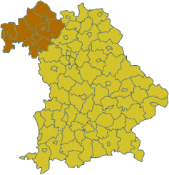

state = Bavaria
capital = Würzburg
area = 9531.59
population = 1337876
population_as_of = 31 Dec. 2006
dissolved =
url = [http://www.regierung.unterfranken.bayern.de regierung.unterfranken.bayern.de]

Lower Franconia ( _de. Unterfranken) is one of the three administrative regions of Franconia in Bavaria (seven regions), Germany (22 regions in five Federal States, 11 Federal States are not subdivided into regions).

The district was formed in 1817 under the name of "Untermainkreis" (Lower Main District) and renamed in 1837 as "Unterfranken und Aschaffenburg" (Lower Franconia and Aschaffenburg). In 1933 the regional Nazi Gauleiter Otto Hellmuth insisted on renaming the district "Mainfranken", but after 1945 the name "Unterfranken" was resurrected.

Unterfranken is the north-west part of Franconia and consists of three district-free cities ("Kreisfreie Städte") and nine country districts ("Landkreise").

The major portion of the Franconian wine region is situated in Lower Franconia.

Area and population

Well known people

* Florian Geyer
* Tilman Riemenschneider
* Balthasar Neumann
* Friedrich Rückert
* Wilhelm Conrad Röntgen
* Leonhard Frank
* Carl Diem
* Dirk Nowitzki

Institutes of Higher Education

* Julius-Maximilians-Universität, Würzburg
* [http://www.fh-aschaffenburg.de/index.php?id=222 Fachhochschule Aschaffenburg]
* [http://www.fh-wuerzburg.de/ Fachhochschule Würzburg-Schweinfurt]

ee also

* Middle Franconia
* Upper Franconia

External links

* [http://www.unterfranken.de Official website]
* [http://www.regierung.unterfranken.bayern.de/englisch/17861/index.html Official website in English]
* [http://www.bezirk-unterfranken.de Official website]
* [http://flagspot.net/flags/de-by-uf.html Flag at Flagspot]
* [http://www.gemeindeverzeichnis.de/gem1900//gem1900.htm?unterfranken/unterfranken1900.htm Unterfranken 1910]
* [http://www.unterfranken-in-zahlen.de/ Statistics]
* [http://mein-franken.eu/towns-and-municipalities/lower-franconia.html?L=1 Lower Franconia, described by a native franc resident]


Wikimedia Foundation. 2010.

Игры ⚽ Нужно сделать НИР?

Look at other dictionaries:

  • Lower Franconia — northwestern Bavaria …   Eponyms, nicknames, and geographical games

  • Neunkirchen, Lower Franconia — Neunkirchen …   Wikipedia

  • Franconia (wine region) — Franconia ( Franken ) is a region for quality wine in Germany [ [http://www.wein.de/1464.0.html Wein.de (German Agricultural Society): Franconia] , read on January 1, 2008] situated in the north west of Bavaria in the district of Franconia, and… …   Wikipedia

  • Lower Bavaria — Wappen Bezirk Niederbayern Niederbayern …   Wikipedia

  • Franconia — For other uses, see Franconia (disambiguation). The Franconian coat of arms …   Wikipedia

  • Franconia — /frang koh nee euh, kohn yeuh, fran /, n. a medieval duchy in Germany, largely in the valley of the Main River. * * * German Franken Former duchy, south central Germany. Today it is divided between Rhenish Franconia, now located in the Länder… …   Universalium

  • FRANCONIA —    the name formerly applied to a loosely defined district in Central Germany, which, as the home of the Franks, was regarded as the heart of the Holy Roman Empire; the emperors long continued to be crowned within its boundaries; subsequently it… …   The Nuttall Encyclopaedia

  • Haibach, Lower Franconia — Infobox German Location Name = Haibach Wappen = Wappen Haibach.png lat deg = 49 |lat min = 58 |lat sec = 03 lon deg = 09 |lon min = 11 |lon sec = 49 Lageplan = Bundesland = Bayern Regierungsbezirk = Unterfranken Landkreis = Aschaffenburg Höhe =… …   Wikipedia

  • Stockheim, Lower Franconia — Infobox Ort in Deutschland Name = Stockheim Wappen = Wappen Stockheim Unterfranken.png lat deg = 50 |lat min = 27 lon deg = 10 |lon min = 17 Lageplan = Bundesland = Bayern Regierungsbezirk = Unterfranken Landkreis = Rhön Grabfeld… …   Wikipedia

  • Kirchheim, Lower Franconia — Infobox German Location Name = Kirchheim Wappen = Wappen Kirchheim Unterfranken.png lat deg = 49 |lat min = 39 lon deg = 9 |lon min = 52 Lageplan = Bundesland = Bayern Regierungsbezirk = Unterfranken Landkreis = Würzburg Verwaltungsgemeinschaft …   Wikipedia

Share the article and excerpts

Direct link
Do a right-click on the link above
and select “Copy Link”