- Old Swan
-
For the Blackfoot chief, see Old Swan (chief).
Coordinates: 53°24′43″N 2°55′05″W / 53.412°N 2.918°W
Old Swan
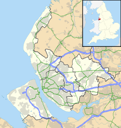
 Old Swan shown within Merseyside
Population 12,938 (2001 Census)[1] OS grid reference SJ390915 Metropolitan borough Liverpool Metropolitan county Merseyside Region North West Country England Sovereign state United Kingdom Post town LIVERPOOL Postcode district L13 Dialling code 0151 Police Merseyside Fire Merseyside Ambulance North West EU Parliament North West England UK Parliament Liverpool Wavertree List of places: UK • England • Merseyside Old Swan is an inner-city area of Liverpool, Merseyside, England and a Liverpool City Council Ward. It is located fairly centrally in the city, bordered by Stoneycroft, Broadgreen, Fairfield and Wavertree. At the 2001 Census, the population of Old Swan was 12,938 (5,999 males, 6,939 females).[1]
The area is named after one of two public houses at a main road junction, the other being The Red House.
Contents
Geography
The A57 road passes through Kensington and Fairfield prior to running through Old Swan and then through Knotty Ash, towards Prescot and on to St Helens.
Housing in the district is mostly in densely-packed terraced houses, though there are exceptions. The popular Doric Park is tucked away behind rows of terraced houses. The Edge Lane retail park runs parallel to Old Swan.
Health
In the area there is an NHS walk-in health centre, along with an emergency surgery.
There are also three dentist surgeries on Derby Lane that deal with a mixture of NHS and private patients.
Economy
Old Swan has a varied collection of clothes and food shops situated along Prescot Road serving local residents. In addition, the area is also served by a large Tesco supermarket this has recently been joined by an Aldi facing it across St. Oswald Street. Further down Prescot Road, away from the City Centre is a Sainsbury's supermarket.
Transport
Fairly regular bus routes 8/9, 10/10A/10B and 139 connect Old Swan to Liverpool City Centre continuing along the Prescot Road to Huyton, Prescot, and St Helens in east Merseyside. Old Swan has other bus links - routes 60, 61/61A, 62, 81/81A and 102, which do not serve Liverpool City Centre but provide important links to other areas of Liverpool including Aigburth, Aintree, Anfield, Bootle, Childwall, Clubmoor, Crosby, Croxteth, Fazakerley, Netherton, Norris Green, Orrell Park, Speke, Walton, Wavertree, West Derby and Woolton.
The Merseytram System (Line 2) was due to run through Old Swan but this has now been cancelled after funding from the British Government was denied.
The M62 motorway starts at the end of Broadgreen Road out of the city, and is the east gateway into the city via Edge Lane Drive.
The nearest railway stations to Old Swan are Broad Green station and Wavertree Technology Park station. Both are operated by Northern Rail and served by trains to and from Liverpool Lime Street to Wigan North Western, Stalybridge via. Manchester Victoria and Warrington Bank Quay.
Education
It contains six schools, including Broadgreen J.M.I., St Annes Stanley C of E Primary, St Oswalds Catholic Primary, Corinthian Avenue Primary, St Cuthbert Catholic Primary and Broadgreen International School (formerly known as Highfield and Broadgreen Community Comprehensive), which is a specialised sixth form and technology college. There are also three nurseries in the area. Old Swan offers a recently refurbished[2] library,[3] originally opened in 1913 as a reading room.
Notable residents
- Former Manchester United manager Ron Atkinson was born in Old Swan.
- Alan Caldwell, known as Rory Storm, rock n roll singer of the late 1950s and early 1960s. He was born and lived his entire life in Old Swan, was a member of Old Swan Boys Club (1956-57) and attended St Margaret's Anfield School.
- Tommy Scott, lead singer with nineties band Space lived in Old Swan at the height of their fame.
- The parents of Hollywood actor Mike Myers originate from Old Swan.
References
- ^ a b 2001 Census: Old Swan, Office for National Statistics, http://neighbourhood.statistics.gov.uk/dissemination/LeadKeyFigures.do?a=3&b=5941442&c=old+swan&d=14&e=16&g=358518&i=1001x1003x1004&m=0&r=1&s=1213469188774&enc=1, retrieved 14 June 2008
- ^ Old Swan turns over a new leaf, Liverpool City Council, 3 March 2006, http://www.liverpool.gov.uk/News/archive/2006/newsdetail_1596.asp, retrieved 12 January 2009
- ^ Old Swan Community Library, Liverpool City Council, http://www.liverpool.gov.uk/Leisure_and_culture/Libraries/How_to_find_us/Old_Swan_library/index.asp, retrieved 12 January 2009
External links
- Liverpool Today
- Liverpool City Council, Ward Profile: Old Swan
- Liverpool Street Gallery - Liverpool 13
- Old Swan and surrounding area - History - Pics
Districts and Wards of the City of Liverpool Districts Aigburth · Allerton · Anfield · Belle Vale · Broadgreen · Canning · Childwall · Chinatown · City Centre · Clubmoor · Croxteth · Dingle · Dovecot · Edge Hill · Everton · Fairfield · Fazakerley · Garston · Gateacre · Gillmoss · Grassendale · Hunts Cross · Kensington · Kirkdale · Knotty Ash · Mossley Hill · Netherley · Norris Green · Old Swan · Orrell Park · St Michael's Hamlet · Speke · Stoneycroft · Toxteth · Tuebrook · Vauxhall · Walton · Wavertree · West Derby · WooltonWards Allerton and Hunts Cross · Anfield · Belle Vale · Central · Childwall · Church · Clubmoor · County · Cressington · Croxteth · Everton · Fazakerley · Greenbank · Kensington and Fairfield · Kirkdale · Knotty Ash · Mossley Hill · Norris Green · Old Swan · Picton · Princes Park · Riverside · Speke-Garston · St Michael's · Tuebrook and Stoneycroft · Warbreck · Wavertree · West Derby · Woolton · Yew TreeCategories:- Districts of Liverpool
Wikimedia Foundation. 2010.

