- Orrell Park
-
Coordinates: 53°27′00″N 2°57′31″W / 53.450°N 2.9585°W
Orrell Park
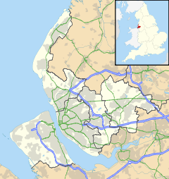
 Orrell Park shown within Merseyside
OS grid reference SJ3602896740 Metropolitan borough Liverpool Metropolitan county Merseyside Region North West Country England Sovereign state United Kingdom Post town LIVERPOOL Postcode district L9 Dialling code 0151 Police Merseyside Fire Merseyside Ambulance North West EU Parliament North West England UK Parliament Liverpool Walton List of places: UK • England • Merseyside Orrell Park is a district of Liverpool, Merseyside, England. It is a small residential area of northern Liverpool between the large districts of Aintree and Walton.
The area features Orrell Park railway station of the Merseyrail system. A popular night club and concert venue, The Ballroom, is located in the district. The area has historical and cultural links which include the Titanic, The Beatles and The Canadian Army Mutiny in the First World War.
External links
Districts and Wards of the City of Liverpool Districts Aigburth · Allerton · Anfield · Belle Vale · Broadgreen · Canning · Childwall · Chinatown · City Centre · Clubmoor · Croxteth · Dingle · Dovecot · Edge Hill · Everton · Fairfield · Fazakerley · Garston · Gateacre · Gillmoss · Grassendale · Hunts Cross · Kensington · Kirkdale · Knotty Ash · Mossley Hill · Netherley · Norris Green · Old Swan · Orrell Park · St Michael's Hamlet · Speke · Stoneycroft · Toxteth · Tuebrook · Vauxhall · Walton · Wavertree · West Derby · WooltonWards Allerton and Hunts Cross · Anfield · Belle Vale · Central · Childwall · Church · Clubmoor · County · Cressington · Croxteth · Everton · Fazakerley · Greenbank · Kensington and Fairfield · Kirkdale · Knotty Ash · Mossley Hill · Norris Green · Old Swan · Picton · Princes Park · Riverside · Speke-Garston · St Michael's · Tuebrook and Stoneycroft · Warbreck · Wavertree · West Derby · Woolton · Yew TreeCategories:- Districts of Liverpool
- Merseyside geography stubs
Wikimedia Foundation. 2010.

