- Childwall
-
Coordinates: 53°23′42″N 2°52′52″W / 53.395°N 2.881°W
Childwall 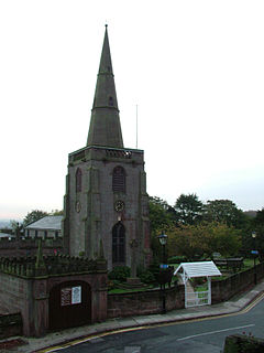
All Saints' Church, Childwall (October 2006).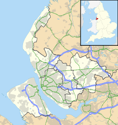
 Childwall
Childwall shown within MerseysidePopulation 14,085 (2008)[1] OS grid reference SJ414890 Metropolitan borough City of Liverpool Metropolitan county Merseyside Region North West Country England Sovereign state United Kingdom Post town LIVERPOOL Postcode district L16 Dialling code 0151 Police Merseyside Fire Merseyside Ambulance North West EU Parliament North West England UK Parliament Liverpool Wavertree List of places: UK • England • Merseyside Childwall is a suburb of Liverpool, Merseyside, England and a Liverpool City Council Ward. It is located to the south of the city, bordered by Gateacre, Wavertree, Belle Vale, Broadgreen, Bowring Park and Mossley Hill. In 2008 the population was recorded as 14,085.[1]
Contents
History
The earliest recorded reference to Childwall was in the Domesday Book of 1086.
"Four Radmans held Childwall as four Manors. There is half a hide. It was worth eight shillings. There was a priest, having half a carucate of land in frank almoign."[2][3]
Childwall was known as Cileuuelle in the 1086 Domesday Book meaning 'a stream where youngsters meet' from the Old English words cild and wella. Historically the name has been recorded as Childewalle (1212 and 1332), Chaldewall (1238), Childwall (1261), Childewelle (1291), Chaldewal (1305) and Childewall (1354).[4]
Childwall was traditionally part of the West Derby Hundred. It was an urban district from the Local Government Act 1894 until it was annexed to Liverpool in 1913.[5]
All Saints' Church, Childwall, is the oldest church in Liverpool and still has a lively and full congregation to this date. Childwall once had a a large Jewish community, but since the 1980s this has been in gradual decline with many now living in Gateacre and Allerton.
Description
Childwall is dominated by the "Childwall Fiveways", a large roundabout that is one of the busiest in Liverpool. Housing is almost entirely detached or semi-detached; there are very few terraces within Childwall. The area's pleasant greenery in abundance and range of large houses makes it one of Liverpool's most sought-after suburbs.
Childwall's public houses include the Childwall Abbey, the Halfway House and the Childwall Fiveways. From 2009, the Halfway House became the starting point for regular Tom Slemen Haunted Liverpool Ghost and Murder Tours of Childwall, in aid of Freshfields Animal Rescue.
Lime Pictures, formerly Mersey Television, is based in the area and produces Hollyoaks for Channel Four. Childwall was also the home of Brookside until 2003, and the BBC's Grange Hill between 2003 and 2008.
Education
Primary Schools
- Childwall Church of England Primary School
- King David Schools (encompassing a Nursery, Primary, High School and Sixth Form)
- Our Lady's Bishop Eton Roman Catholic Primary & Junior School
- Rudston Infant & Junior School
- St Paschal Baylon Roman Catholic Primary School
Secondary Schools
- Childwall Sports College, (known locally as 'The Holt')
- King David High School, (Specialist Humanities College)
Higher Education
Transport
The nearest railway station is either Mossley Hill or Broadgreen. Historically there was also Childwall railway station.
Regular bus services connect the district with Liverpool John Lennon Airport and the city centre, as well as surrounding districts.
Notable residents
- Craig Charles
- Brian Epstein
- Graham Hesketh (see Fiona Mont)
- Jeremiah Markland
- Raymond Quinn
- Ian St John
- Edwina Currie
- Jason Isaacs
- John Flanagan
Government
The elected councillors for Childwall are Cllrs Sir Trevor Jones, Eddie Clein and Pam Clein - all Liberal Democrats.
References
- ^ a b (pdf) Childwall Ward, Liverpool City Council, 2008, http://www.liverpool.gov.uk/Images/tcm21-117862.pdf
- ^ Brief History, All Saints Parish Church, Childwall, http://www.allsaints-childwall.org/html_two/ac/bhist_p1.htm, retrieved 26 March 2008
- ^ Wild, Jonathon, The History of Childwall, http://www.childwall.info/, retrieved 23 January 2009
- ^ Townships: Childwall, A History of the County of Lancaster: Volume 3, British History Online, 1907, pp. 108–111, http://www.british-history.ac.uk/report.aspx?compid=41303, retrieved 6 February 2009
- ^ Liverpool, A Vision Of Britain Through Time, http://www.visionofbritain.org.uk/relationships.jsp?u_id=10027317, retrieved 26 March 2008
External links
- Save Childwall Church Graveyard
- Liverpool Today
- Liverpool City Council, Ward Profile: Childwall (March 2006)
- MultiMap.com: Childwall Fiveways aerial photo
- Port Cities: Childwall Fiveways photo (1935)
- Port Cities: Childwall Valley Road photo (1931)
- Liverpool Street Gallery - Liverpool 16
- Disused Stations: Childwall
- Haunted Liverpool Ghost Walks website
- HOMEsure Property - Childwall's Local Independent Sales, Lettings & Management Agency
Districts and Wards of the City of Liverpool Districts Aigburth · Allerton · Anfield · Belle Vale · Broadgreen · Canning · Childwall · Chinatown · City Centre · Clubmoor · Croxteth · Dingle · Dovecot · Edge Hill · Everton · Fairfield · Fazakerley · Garston · Gateacre · Gillmoss · Grassendale · Hunts Cross · Kensington · Kirkdale · Knotty Ash · Mossley Hill · Netherley · Norris Green · Old Swan · Orrell Park · St Michael's Hamlet · Speke · Stoneycroft · Toxteth · Tuebrook · Vauxhall · Walton · Wavertree · West Derby · WooltonWards Allerton and Hunts Cross · Anfield · Belle Vale · Central · Childwall · Church · Clubmoor · County · Cressington · Croxteth · Everton · Fazakerley · Greenbank · Kensington and Fairfield · Kirkdale · Knotty Ash · Mossley Hill · Norris Green · Old Swan · Picton · Princes Park · Riverside · Speke-Garston · St Michael's · Tuebrook and Stoneycroft · Warbreck · Wavertree · West Derby · Woolton · Yew TreeCategories:- Districts of Liverpool


Wikimedia Foundation. 2010.