- North and South Cliffe
-
North and South Cliffe 
Civil parish Status: Parish Governance: Parish Council Population: 96 (2001 census)[1] Administration Primary council: East Riding of Yorkshire Region: Yorkshire and the Humber Coordinates: 53°49′N 0°40′W / 53.817°N 0.667°WCoordinates: 53°49′N 0°40′W / 53.817°N 0.667°W Politics UK Parliament: East Yorkshire European Parliament: Yorkshire and the Humber North and South Cliffe is a civil parish in the East Riding of Yorkshire, England. It is situated approximately 3 miles (4.8 km) south of the market town of Market Weighton and covering an area of 1,412.967 hectares (3,491.52 acres).[2]
The civil parish is formed by the villages of North Cliffe and South Cliffe.
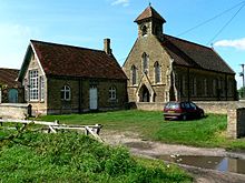 Parish Church of St John, serving North and South Cliffe
According to the 2001 UK census, North and South Cliffe parish had a population of 96.[1]
References
- ^ a b "2001 Census: Area Profiles - North and South Cliffe" (PDF). East Riding of Yorkshire Council. http://www.eastriding.gov.uk/corp-docs/researchgroup/parishprofiles/NORTH+AND+SOUTH+CLIFFE.pdf. Retrieved 19 May 2008.
- ^ "2001 Census Area Profile" (PDF). East Riding of Yorkshire County Council. 2004. http://www.eastriding.gov.uk/corp-docs/researchgroup/parishprofiles/NORTH+AND+SOUTH+CLIFFE.pdf. Retrieved 21 March 2011.
- Gazetteer — A–Z of Towns Villages and Hamlets. East Riding of Yorkshire Council. 2006. pp. 8, 10.
Categories:- Civil parishes in the East Riding of Yorkshire
- East Riding of Yorkshire geography stubs


Wikimedia Foundation. 2010.