North Cliffe

North Cliffe

Coordinates: 53°49′21″N 0°40′25″W / 53.822384°N 0.673713°W / 53.822384; -0.673713

North Cliffe
North Cliffe is located in East Riding of Yorkshire
North Cliffe

 North Cliffe shown within the East Riding of Yorkshire
OS grid reference SE874370
Parish North and South Cliffe
Unitary authority East Riding of Yorkshire
Ceremonial county East Riding of Yorkshire
Region Yorkshire and the Humber
Country England
Sovereign state United Kingdom
Post town YORK
Postcode district YO43
Dialling code 01430
Police Humberside
Fire Humberside
Ambulance Yorkshire
EU Parliament Yorkshire and the Humber
UK Parliament East Yorkshire
List of places: UK • England • Yorkshire

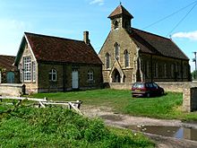
North Cliffe is a hamlet in the East Riding of Yorkshire, England. It is situated about 3 miles (4.8 km) north of North Cave, 2 miles (3.2 km) west of Newbald and 3 miles (4.8 km) south of Market Weighton. The hamlet bestrides Cliffe Road. On the eastern side lies the houses, and to the west is a small church/chapel.

Parish Church of St John, serving North Cliffe and South Cliffe

Together with South Cliffe it forms the civil parish of North and South Cliffe.

North Cliffe is the home of The White Rose Polo Club which is a member of the Hurlingham Polo Association.[1]

References

  1. ^ "About Polo in Yorkshire". White Rose Polo Club. http://www.whiterosepolo.co.uk/about.html. Retrieved 24 March 2010. 
  • Gazetteer — A–Z of Towns Villages and Hamlets. East Riding of Yorkshire Council. 2006. p. 8. 


Wikimedia Foundation. 2010.

Игры ⚽ Поможем решить контрольную работу

Look at other dictionaries:

  • North and South Cliffe — ‹ The template below (Infobox England and Wales civil parish) is being deleted. See templates for discussion for the discussion that led to this result. › North and South Cliffe …   Wikipedia

  • North Kent Marshes — Cliffe Creek Fleet. The complex landscape of the marshes, in the foreground a fleet, then a bank and one of the Pools managed by the RSPB, then the chalk outcrop, heavily quarried, where one finds Cliffe village …   Wikipedia

  • Cliffe Park railway station — Cliffe Park Location Place Rudyard, Staffordshire Area Staffordshire Moorlands Grid reference …   Wikipedia

  • Cliffe — could be Cliffe, Kent, Kent Cliffe, Richmondshire, North Yorkshire Cliffe, Selby, North Yorkshire Jess Cliffe (online handle cliffe), Valve Software The Cliffe a residence in Peppermint Grove, Western Australia This disambiguation page lists… …   Wikipedia

  • Cliffe railway station — Cliffe Location Place Cliffe Area Medway …   Wikipedia

  • North Staffordshire Railway — Locale North Staffordshire United Kingdom Dates of operation 1845–1923 Successor London, Midland and Sco …   Wikipedia

  • North Hunterdon High School — Location 1445 Route 31 Annandale, NJ 08801 Information Type Public high school Established 1951 School district …   Wikipedia

  • Cliffe, Richmondshire — For the other village of the same name in North Yorkshire, see Cliffe, Selby. Cliffe George Hotel at Cliffe Population 1,447  OS  …   Wikipedia

  • Cliffe, Selby — For the other village of the same name in North Yorkshire, see Cliffe, Richmondshire. Coordinates: 53°46′57″N 0°59′42″W / 53.782500°N 0.995000°W …   Wikipedia

  • Cliffe Vale, Staffordshire — Not to be confused with Cliffe Vale, Yorkshire or Cliffe Vale, Nottingham. Coordinates: 53°00′19″N 2°06′48″W / 53.0054°N 2.1133°W / …   Wikipedia

Share the article and excerpts

Direct link
Do a right-click on the link above
and select “Copy Link”