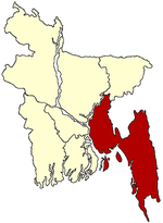
- Companiganj Upazila, Noakhali
-
Companiganj
কোম্পানিগঞ্জ— Upazila — Location in Bangladesh Coordinates: 22°52.5′N 91°17′E / 22.875°N 91.283°ECoordinates: 22°52.5′N 91°17′E / 22.875°N 91.283°E Country  Bangladesh
Division Chittagong Division District Noakhali District Area - Total 305.33 km2 (117.9 sq mi) Population (1991) - Total 183,351 - Density 601/km2 (1,556.6/sq mi) Time zone BST (UTC+6) Postal code 3850 Website /Companiganj.gif Official Map of Companiganj Companiganj (Bengali: কোম্পানিগঞ্জ) is an Upazila of Noakhali District in the Division of Chittagong, Bangladesh.
Contents
Geography
Companiganj is located at 22°52′30″N 91°17′00″E / 22.8750°N 91.2833°E . It has 30,847 units of household and total area 305.33 km². The upazila is bounded by Senbgh and daganbhuiyan upazilas on the north, Noakhali Sadar and Sandwip upazilas on the south, Sonagazi and Mirsharai upazilas on the east, Noakhali Sadar upazila on the west. Main rivers are Little Feni and Bamni.
Companiganj (Town) stands six km to the south of Maijdi Road. The town consists of six mouzas. It has an area of 6.5 km2.
Very popular nowadays.
Demographics
The town has a population of 17340; male 52.77%, female 47.23%; population density per km2 2668. The town has one dakbungalow.
As of the 1991 Bangladesh census, Companiganj has a population of 183351. Males constitute are 49.71% of the population, and females 50.29%; Muslim 91.85%, Hindu 8.10% and Christian 0.05%; population density 601 per km2. This Upazila's eighteen up population is 83104. Companiganj has an average literacy rate of 34.5% (7+ years); male 41.5% and female 27.8%; and the national average of 32.4% literate.[1]
Administrative
Companiganj thana, now an upazila, was established in 1888. The upazila consists of 11 union parishads/councils, 39 mouzas and 41 villages.2
Educational institutions
Government college 1, non-government college 2, government high school 2, non-government high school 26, madrasa 9, technical institution 1, government primary school 57, non-government primary school 19. Noted educational institutions: Basurhat AHC Government High School (1911), Bamni High School (1914), Basurhat Islamia Senior Madrasa (1914), Bamni Achhia Senior Madrasa (1915).
Cultural organisations Club 22, public library 3, cinema hall 1, playground 26.
Historical Events
During the War of Liberation quite a few encounters were held between the Mukti Bahinis and the Pak army in Companiganj upazila in which seven Muktijoddhas including Sadar BLF Commander Ohidur Rahman Wadud were killed. Marks of the War of Liberation Mass grave near Sluice Gate no 16 of the upazila.
See also
References
- ^ "Population Census Wing, BBS.". Archived from the original on 2005-03-27. http://web.archive.org/web/20050327072826/http://www.bangladeshgov.org/mop/ndb/arpc91_v1/tables04.htm. Retrieved November 10, 2006.
 Upazilas of the Chittagong Division
Capital: Chittagong Bandarban District 
Brahmanbaria District Chandpur District Chittagong District Anwara · Banshkhali · Boalkhali · Chandanaish · Fatikchhari · Hathazari · Lohagara · Mirsharai · Patiya · Rangunia · Raozan · Sandwhip · Satkania · SitakundaComilla District Barura · Brahmanpura · Burichong · Chandina · Chauddagram · Daudkandi · Debidewer · Homna · Comilla Sadar Adarsha · Comilla Sadar South · Laksam · Muradnagar · Nangalkot · Titas · Meghna · MonoharganjCox's Bazar District Feni District Khagrachari District Dighinala · Khagrachhari · Lakshmichhari · Mahalchhari · Manikchhari · Matiranga · Panchhari · RamgarhLakshmipur District Noakhali District Rangamati District Bagaichhari · Barkal · Kawkhali · Belaichhari · Kaptai · Juraichhari · Langadu · Mannerchar · Rajasthali · RangamatiCategories:- Upazilas of Noakhali District
Wikimedia Foundation. 2010.

