- Manaure, La Guajira
-
For the other municipality of the same name, see Manaure, Cesar.
Manaure Salt mines in Manaure, La Guajira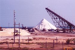

Flag
SealLocation of the town and municipality of Manaure in the Department of La Guajira.
Country Colombia Region Caribbean Department La Guajira Foundation Government - Mayor Humberto Martinez Fajardo (C)[1] Area - Total 1,971 km2 (761 sq mi) Population (2005) - Total 68,578 [2] Website
manaure-laguajira.gov.co/* Manaure or Salinas de Manaure is a town and municipality located in the Colombian Department of La Guajira. Manaure's main economic activity is the exploitation of the vast amounts of salt in the area.
Contents
Geography
The municipality of Manaure is located in northern most part of South America, on the arid plains of the Guajira Peninsula, in the Colombian Caribbean region, bordering to the north with the Caribbean Sea to the east with the municipality of Uribia; to the south with the municipality of Maicao and to the west with the municipality of Riohacha.[3]
The municipality of Manaure is within the Guajira-Barranquilla xeric scrub with water streams determined by precipitations during the rainy seasons. The municipality seat of Manaure is crossed by the Limón Creek which flows into the Caribbean sea. The coastline has high concentration of salt, rocks and clay over predominantly flat plains, slightly undulated in some areas.[3]
Climate
Climate in the municipality of Manaure is hot and dry throughout the year, averaging between 28°C and 38°C throughout the year with constant winds from the northeastern trade winds, evaporation of humidity is high. The area has two rainy seasons averaging 150 mm³ from May to June and from October to November) and two dry seasons in between these months.[4]
History
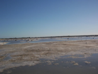 Manaure salt lagoons
Chronicles from the Spanish explorer first detailed some indigenous in the area called Coanaos which traveled between the Cabo de la Vela and the region of Valledupar to exchange salt for gold. During the 19th century salt in the region was exploited at Honda Bay and Quebrada Bay on coasts of what is part of the municipality of Manaure which naturally formed lagoons. In 1777 the Spanish government ordered the administration of the Salinas.[5]
In 1824 the government declared the Salinas or salt mines as national patrimony of the nation establishing a regulatory price control. In 1932 the bank of the Republic was given authority over the administration and exploitation of salt mines in Zipaquirá, Nemocón and Sesquilé.[5]
Industrial exploitation and processing of salt in Manaure began in the 1920s when the government gave concessions to individual investors for the exploitation of the salt mine and until the 1940s the mode of collection went from artisan to industrial, when the Bank of the Republic took over the Manaure salt mines. By 1948 salt production in Manaure was between 20,000 and 30,000 tons a year. In 1970 the concession of Manaure salt mines was transferred to the IFI-Concesión Salinas which intensified the production to one million tons a year.[5]
The Wayuu began to claim the area as their ancestral land and historical owners of Manaure. In 1991 the government recognized the claim by the Wayuu and agreed to reorganize production and work conditions under a mixed economy, in which the indigenous would have 25% of the stocks in the company. The accords were not met and the Wayuus sued the government in 1994. The court ordered the creation of Sociedad Salinas de Manaure, SAMA based on the original agreement and linked to the then Ministry of Development. The Wayuu would have 25%, but once again the agreements were not met due to legal problems. In 2002 Law 773 of the same year reestablished the creation of the SAMA, distributing earnings among the Ministry of Development (51%) the indigenous Association "Sumain Ichi" (25%) and the municipality of Manaure (25%).[5]
References
- ^ (Spanish) Colombian Registry of the Civil State: 2007 election results
- ^ (Spanish) Observatorio del Caribe Colombiano: Grupo Regional de investigación en economía y competitividad en el Caribe colombiano by Weildler Guerra, Paola Quintero, Jorge Quintero and Ana María Maldonado
- ^ a b (Spanish) Manaure: Geography
- ^ (Spanish) Manaure: Climate
- ^ a b c d (Spanish) Bank of the Republic: ASPECTOS HISTORICOS Y SOCIOECONOMICOS DE LAS SALINAS DE MANAURE by Maríía Aguilera Díaz (Riohacha, 14 de octubre de 2004)
External links
- (Spanish)Manaure official website
Municipalities in the Department of La Guajira Albania • Barrancas • Dibulla • Distracción • El Molino • Fonseca • Hatonuevo • La Jagua del Pilar • Maicao • Manaure • Riohacha • San Juan del Cesar • Uribia • Urumita • Villanueva Categories:
- Municipalities of Guajira
- Populated places in the Guajira Department


Wikimedia Foundation. 2010.