- Barrancas, La Guajira
Infobox City
official_name = Barrancas
nickname =
motto =
imagesize =
image_caption =
image_
mapsize = 250px
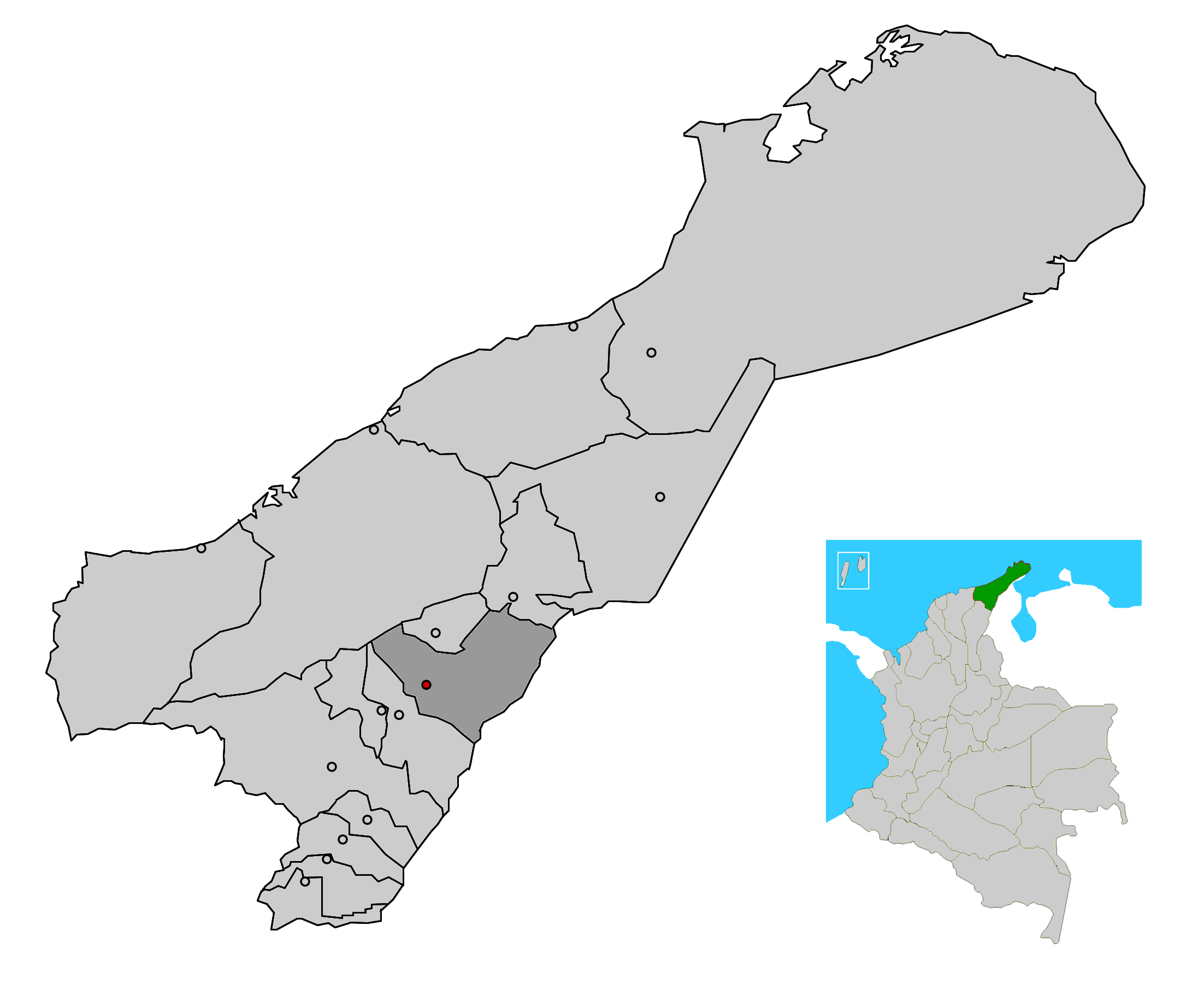
map_caption = Location of the town and municipality of Barrancas in La Guajira Department.
subdivision_type =Country
subdivision_type1 = Region
subdivision_type2 = Department
subdivision_name =Colombia
subdivision_name1 = Caribbean
subdivision_name2 = La Guajira
leader_title =Mayor
leader_name =Juan Carlos Leon Solano (L) [ [http://www.registraduria.gov.co/reselec2007_esc/1028/x.html es icon Colombian Registry of the Civil State: 2007 election results] ]
established_title =
established_date = 1872
area_magnitude =
area_total_sq_mi =
area_total_km2 = 1060
area_land_sq_mi =
area_land_km2 =
area_water_sq_mi =
area_water_km2 =
area_water_percent =
area_urban_sq_mi =
area_urban_km2 = 742
area_metro_sq_mi =
area_metro_km2 =
population_as_of = 2005
population_note = [ [http://www.ocaribe.org/downloads/grupos/economia_competitividad/estudio_zif_guajira_venezuela.pdf es icon Observatorio del Caribe Colombiano: Grupo Regional de investigación en economía y competitividad en el Caribe colombiano by Weildler Guerra, Paola Quintero, Jorge Quintero and Ana María Maldonado] ]
population_total = 22207
population_metro =
population_urban =
population_density_km2 =
population_density_sq_mi =
timezone =
utc_offset = -5
timezone_DST =
utc_offset_DST =
latd= |latm= |lats= |latN=
longd= |longm= |longs= |longW=
elevation_m = 40
elevation_ft =
website =
footnotes =Barrancas is a town and municipality of the
Colombia n Department of La Guajira. The municipality of Barrancas is located to the left margin of theRanchería River in a valley formed between theSierra Nevada de Santa Marta mountains and theSerrania del Perija . Barrancas has a total area of 742 km² and at 40 meters over sea level. The average temperature is 28°C throughout the year and distances from the capital of the Department of La Guajira,Riohacha . It became a municipality in 1892. [ [http://www.laguajira.gov.co/municipios/barrancas.htm es icon Gobernacion de La Guajira - Barrancas] ]Its economy is based on agriculture and coal mining which is exploited by the
Cerrejon coal mine. [ [http://www.laguajira.gov.co/municipios/barrancas.htm es icon Gobernacion de La Guajira - Barrancas] ]Geography
Barrancas is located in the
Guajira Peninsula in theCaribbean Region of Colombia , limiting to the east with theBolivarian Republic of Venezuela ; to the north with the municipalities ofHatonuevo and Albania; to the south with the municipality of Fonseca and to the west with the municipality ofRiohacha . The municipality covers a total are of 742 km² (286.5 sq mi) and is some 40 m (131 ft) over the sea level.The municipality of Barrancas lays in the Valley of Upar formed between the
Sierra Nevada de Santa Marta (west) and theSerrania del Perija (east) and within the basin of theRancheria River .Climate
The climate present in the region is predominantly hot and dry with no mountainous climate variations, maintaining an average temperature throughout the year of 28°C; while in the lower plains temperature can reach 35°C, while in the mountainous area of the municipality the temperature is milder. During the rainy season temperature in the mountainous part of the municipality can reach between 15-18°C while in the dry season 18-24°C. Higher temperature are reached by the end of March, April and May In June and July temperatures drop and in August and September raises. In October and November drops once again and raises in December and January due to the
trade wind s. [ [http://barrancas.galeon.com/ es icon Galeon.com: Barrancas - Climate] ]History
During the war of independence from Spain, on March 26, 1813 the Cabildo of Barrancas insurrected against the local Spanish monarchy authorities destroying images and coat of arms of King
Fernando VII . The cabildo also swore loyalty toSimon Bolivar . The revolt was led by Eugenio Vidal, Javier Lopez Sierra, Jose Rodriguez Romero, Misael Orozco, Pedro Ojeda, Crisanto Solano, Bienvenido Gomez and Pedro Miguel Garavito. [Harvnb|Castro Trespalacios|1979|p=85]Barrancas was one of the villages part of the
Province of Padilla and became a municipality in 1892. [ [http://www.laguajira.gov.co/municipios/barrancas.htm es icon Barrancas: Foundation date] ] It was also one of the five municipalities that grouped to form theDepartment of La Guajira in 1954, then called "Intendencia Nacional de La Guajira" by orders of then military dictatorGustavo Rojas Pinilla . [ [http://barrancas.galeon.com/ es icon Galeon.com: Barrancas - History] ]Politics
*
List of Mayors of Barrancas Demographics
According to projections made by the DANE for the year 2005 the municipality of Barrancas had a population of aproximately 29,856 inhabitants. [ [http://barrancas.galeon.com/ es icon Galeon.com: Barrancas - Population] ]
Economy
The municipality of Barrancas is connected through a highway to the department capital,
Riohacha and the main commercial town in the department,Maicao . Barrancas also has cultural influence and commercial trade related to agriculture from the city ofValledupar in theDepartment of Cesar . Barrancas commercializes in small scale agricultural products such ascoffee ,plantain ,cotton ,maize andyuca , but the main economic activity in the municipality is the exploitation ofcoal atCerrejón coal mine. The Cerrejon coal mine is one of the largest open pit coal mine in the world. [ [http://barrancas-laguajira.gov.co/nuestromunicipio.shtml?apc=m-I1--&m=f&s=m es icon Barrancas: Economy] ]Culture
The municipality celebrates the "
Festival y Reinado Nacional del Carbón " (Coal National festival and Pageant) in October. [ [http://www.sinic.gov.co/SINIC/ColombiaCultural/ColCulturalBusca.aspx?AREID=3&SECID=8&IdDep=44&COLTEM=215 es icon National System for Cultural Information: Festival y Reinado Nacional del Carbón] ]Notes
References
*citation|last=Castro Trespalacios|first=Pedro|last2=|first2=|authorlink=|title=Culturas Aborigenes Cesarences e Independencia de Valle de Upar|location=Bogota|publisher=Casa de la Cultura de Valledupar|year=1979|isbn=
External links
* [http://barrancas.galeon.com/ barrancas.galeon - Barrancas]
* [http://www.laguajira.gov.co/municipios/barrancas.htm Gobernacion de La Guajira - Barrancas]
* [http://barrancas-laguajira.gov.co/sitio.shtml Barrancas official website]
Wikimedia Foundation. 2010.