- La Jagua del Pilar
Infobox City
official_name = La Jagua del Pilar
nickname =
motto =
imagesize =
image_caption =
image_
mapsize = 250px
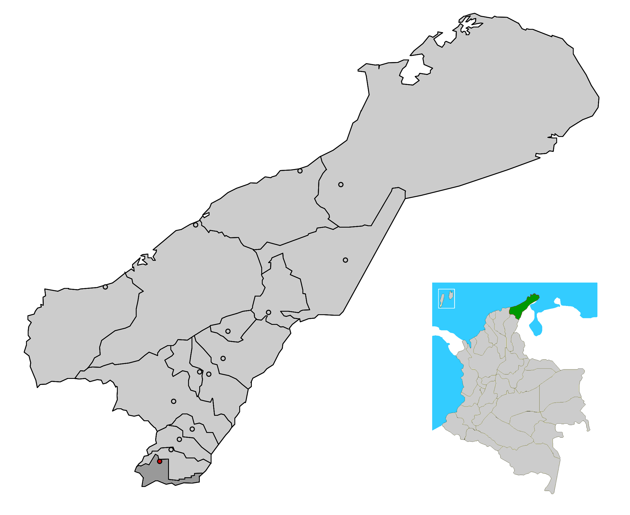
map_caption = Location of the town and municipality of La Jagua del Pilar in the Department of La Guajira.
subdivision_type =Country
subdivision_type1 = Region
subdivision_type2 = Department
subdivision_name =Colombia
subdivision_name1 = Caribbean
subdivision_name2 = La Guajira
leader_title =Mayor
leader_name =Jose Augusto Manjarrez (C) [ [http://www.registraduria.gov.co/reselec2007_esc/1028/x.html es icon Colombian Registry of the Civil State: 2007 election results] ]
established_title = Foundation
established_date =1795
area_magnitude =
area_total_sq_mi =
area_total_km2 = 152
area_land_sq_mi =
area_land_km2 =
area_water_sq_mi =
area_water_km2 =
area_water_percent =
area_urban_sq_mi =
area_urban_km2 = 5
area_metro_sq_mi =
area_metro_km2 =
population_as_of =2005
population_note = [ [http://www.ocaribe.org/downloads/grupos/economia_competitividad/estudio_zif_guajira_venezuela.pdf es icon Observatorio del Caribe Colombiano: Grupo Regional de investigación en economía y competitividad en el Caribe colombiano by Weildler Guerra, Paola Quintero, Jorge Quintero and Ana María Maldonado] ]
population_total = 2196
population_metro =
population_urban =
population_density_km2 =
population_density_sq_mi =
timezone =
utc_offset = -5
timezone_DST =
utc_offset_DST =
latd= |latm= |lats= |latN=
longd= |longm= |longs= |longW=
elevation_m = 450
elevation_ft =
website =
[http://www.lajaguadelpilar-laguajira.gov.co/sitio.shtml www.lajaguadelpilar-laguajira.gov.co/]
footnotes = *La Jagua del Pilar (literally "The Jagua of the Pillar") is a town and municipality in the
Colombia n Department of La Guajira. The municipality has a total area of 187 km² and located some 450 meters over sea level and with an average temperature of 27°C. La Jagua del Pilar became a municipality of La Guajira in1998 . [ [http://www.laguajira.gov.co/municipios/lajagua.htm es icon Government of La Guajira: La Jagua del Pilar] ]Geography
The municipality of La Jagua del Pilar is located in the southern area of the
Guajira Peninsula limiting to the north with the municipality ofUrumita ; east with theBolivarian Republic of Venezuela and to the south and west with theDepartment of Cesar covering a total area of 152 km². The area of the municipality is mostly flat with some mountains near theSerrania del Perija mountain range and crossed by the Perija and Marquezote rivers and theLos Martires stream , among others. The municipality seat is located some 450 m above sea level. [ [http://www.lajaguadelpilar-laguajira.gov.co/nuestromunicipio.shtml?apc=m-I1--&m=f&s=m es icon La Jagua del Pilar: Geography] ]Climate
The average temperature in the municipality is 28°C through out the year, presenting two rainy season and two dry seasons. Climate also varies depending on mountain altitude. [ [http://www.lajaguadelpilar-laguajira.gov.co/nuestromunicipio.shtml?apc=m-I1--&m=f&s=m es icon La Jagua del Pilar: Climate] ]
History
The area of the present-day municipality of La Jagua del Pilar was populated by indigenous peoples pertaining to the
Wayuu andWiwas ethnic groups. During the period of Independence from Spain the area was a farm owned byMaría de la Concepción Loperena Ustariz , fromValledupar , one of the few women who supported the independence movement ofSimon Bolivar . Loperena donated more than a hundred horses to the Patriot army. She also donated her state to build a new settlement which was named "La Jagua del Pedregal". The new settlement was established by Don Manuel José Fernández de Castro and Don Bartolo Ustariz onOctober 12 ,1795 . The name was later changed to La jagua del Pilar to honor Virgin Mary,Our Lady of the Pillar . [ [http://www.lajaguadelpilar-laguajira.gov.co/nuestromunicipio.shtml?apc=m-I1--&m=f&s=m es icon La Jagua del Pilar: History] ]On
May 6 ,1998 the corregimiento of La Jagua del Pilar became a municipality, segregating from the municipality ofUrumita by ordinance 018 of the same year declared by theDepartment Assembly of La Guajira and is covered also by Law 14 of1969 also known as the "Frontiers Law" for having boundaries withVenezuela . [ [http://www.lajaguadelpilar-laguajira.gov.co/nuestromunicipio.shtml?apc=m-I1--&m=f&s=m es icon La Jagua del Pilar: History] ] [ [http://ssiglims.igac.gov.co/ssigl/datosLimites/44-ORD-018-1998a-Jagua%20Pilar.txt es icon Agustin Codazzi Geographic Institute: ORDENANZA NUMERO 018 DE 1998] ]Economy
The economy is based primarily on agriculture. [ [http://www.laguajira.gov.co/municipios/lajagua.htm es icon Government of La Guajira: La Jagua del Pilar] ]
Cattle Ranching is practiced mostly extensively and inlatifundio s. The main agricultural plantations arecotton ,maize ,plantain andyuca . [ [http://www.lajaguadelpilar-laguajira.gov.co/nuestromunicipio.shtml?apc=m-I1--&m=f&s=m es icon La Jagua del Pilar: Economy] ]Culture
La Jagua del Pilar venerates the "Virgen del Carmen" (Virgin of Carmen) a local Roman Catholic tradition on July 16 of each year. Every October 12 of each year the municipality also celebrates the
Our Lady of the Pillar along theVela del Marquezote festival . [ [http://www.lajaguadelpilar-laguajira.gov.co/nuestromunicipio.shtml?apc=m-I1--&m=f&s=m es icon La Jagua del Pilar: Culture] ]References
External links
*es icon [http://www.lajaguadelpilar-laguajira.gov.co/sitio.shtml La Jagua del Pilar official website]
*es icon [http://www.laguajira.gov.co/municipios/lajagua.htm Gobernacion de La Guajira - La Jagua del Pilar]
Wikimedia Foundation. 2010.