Ousefleet

Ousefleet

Coordinates: 53°41′54″N 0°44′50″W / 53.698232°N 0.747219°W / 53.698232; -0.747219

Ousefleet
Ousefleet is located in East Riding of Yorkshire
Ousefleet

 Ousefleet shown within the East Riding of Yorkshire
OS grid reference SE828231
Parish Twin Rivers
Unitary authority East Riding of Yorkshire
Ceremonial county East Riding of Yorkshire
Region Yorkshire and the Humber
Country England
Sovereign state United Kingdom
Post town GOOLE
Postcode district DN14
Dialling code 01405
Police Humberside
Fire Humberside
Ambulance Yorkshire
EU Parliament Yorkshire and the Humber
UK Parliament Brigg and Goole
List of places: UK • England • Yorkshire

Ousefleet is a small hamlet in the East Riding of Yorkshire, England approximately 5 miles (8 km) east of Goole. It is located just south of the River Ouse and north of the A161 road between Goole and Scunthorpe.

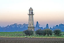
The Whitgift Lighthouse, on the west side of Ousefleet

It forms part of the civil parish of Twin Rivers.

Ousefleet was previously a civil parish that was part of the Goole Rural District in the West Riding of Yorkshire from 1894 to 1974, then in Boothferry district of Humberside until 1996.

Ousefleet is listed by Ordnance Survey as being near to the grid square (on 1:50000 and 1:25000 maps) that has the least detail (a pylon line).[1][2]

Ousefleet has a Village Hall that was a former School of Victorian origin with some extensions added during the 20th century. The Hall Management Committee are currently trying to raise funds to carry out much needed improvements.

Ousefleet also holds a Village Show, generally in August. The Show was revived in 1965 and is still going strong.

References

  1. ^ "Map Zone". Ordnance Survey. http://mapzone.ordnancesurvey.co.uk/mapzone/didyouknow/whatis/q_12_87.html. Retrieved 3 May 2008. 
  2. ^ "One pylon marks the spot". BBC News Online. BBC. 15 October 2001. http://news.bbc.co.uk/1/hi/england/1600225.stm. Retrieved 16 April 2010. 
  • Gazetteer — A–Z of Towns Villages and Hamlets. East Riding of Yorkshire Council. 2006. p. 9. 


Wikimedia Foundation. 2010.

Игры ⚽ Поможем написать курсовую

Look at other dictionaries:

  • River Ouse, Yorkshire — Infobox River | river name = River Ouse caption = The River Ouse in York origin = Swale Nab, near Linton on Ouse mouth = River Humber at Ousefleet basin countries = United Kingdom (England) length = 55 miles elevation = 9 m (30 ft) discharge =… …   Wikipedia

  • List of places in Yorkshire — This is a list of cities, towns and villages in the historic English county of Yorkshire. See the list of places in England for places in other counties.See:List of civil parishes in the East Riding of Yorkshire, :List of civil parishes in North… …   Wikipedia

  • Driffield Navigation — The restored swing bridge at Brigham Original owner Driffield Navigation Commissioners Date of act 1767 …   Wikipedia

  • Goole Rural District — Goole was a rural district in the West Riding of Yorkshire, England from 1894 to 1974.It was created under the Local Government Act 1894, based on most of the Goole rural sanitary district (two parishes of which in Lincolnshire became part of the …   Wikipedia

  • Whitgift, East Riding of Yorkshire — infobox UK place country = England latitude = 53.695503 longitude = 0.765778 official name = Whitgift population = civil parish = Twin Rivers unitary england = East Riding of Yorkshire region = Yorkshire and the Humber lieutenancy england = East… …   Wikipedia

  • List of QI episodes (A series) — infobox tvseason season name = QI Series A caption = The front cover of the QI Series A DVD, featuring Stephen Fry (right) and Alan Davies (left). dvd release date = 6 November 2006 country = UK network = BBC first aired = 11 September 2003 last… …   Wikipedia

  • Twin Rivers, East Riding of Yorkshire — Infobox England and Wales civil parish Parish = Twin Rivers Status = Parish Governance = Parish Council Population = 357 (2001 census) District = East Riding of Yorkshire Region = Yorkshire and the Humber County = Country = the East Riding of… …   Wikipedia

  • Honfleur — Pour les articles homonymes, voir Honfleur (homonymie). 49° 25′ 11″ N 0° 14′ 02″ E …   Wikipédia en Français

  • Ouse du Yorkshire — 53° 56′ 49″ N 1° 04′ 50″ W / 53.94684, 1.08044 …   Wikipédia en Français

  • Ouse du yorkshire — Pour les articles homonymes, voir Ouse. Ouse …   Wikipédia en Français

Share the article and excerpts

Direct link
Do a right-click on the link above
and select “Copy Link”