- Moorefield Township, Harrison County, Ohio
-
Moorefield Township, Ohio — Township — Municipalities and townships of Harrison County.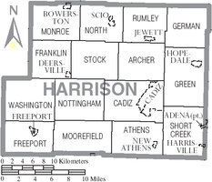
Coordinates: 40°11′45″N 81°9′40″W / 40.19583°N 81.16111°WCoordinates: 40°11′45″N 81°9′40″W / 40.19583°N 81.16111°W Country United States State Ohio County Harrison Area – Total 27.5 sq mi (71.3 km2) – Land 26.9 sq mi (69.7 km2) – Water 0.6 sq mi (1.6 km2) Elevation[1] 1,099 ft (335 m) Population (2000) – Total 420 – Density 15.6/sq mi (6.0/km2) Time zone Eastern (EST) (UTC-5) – Summer (DST) EDT (UTC-4) ZIP code 43907 Area code(s) 740 FIPS code 39-51940[2] GNIS feature ID 1086279[1] Moorefield Township is one of the fifteen townships of Harrison County, Ohio, United States. The 2000 census found 420 people in the township.[3]
Contents
Geography
Located in the southern part of the county, it borders the following townships:
- Nottingham Township - north
- Cadiz Township - northeast
- Athens Township - east
- Flushing Township, Belmont County - south
- Freeport Township - west
- Washington Township - northwest
No municipalities are located in Moorefield Township, although the unincorporated community of Piedmont lies in the western part of the township.
Name and history
Statewide, the only other Moorefield Township is located in Clark County.
Government
The township is governed by a three-member board of trustees, who are elected in November of odd-numbered years to a four-year term beginning on the following January 1. Two are elected in the year after the presidential election and one is elected in the year before it. There is also an elected township fiscal officer,[4] who serves a four-year term beginning on April 1 of the year after the election, which is held in November of the year before the presidential election. Vacancies in the fiscal officership or on the board of trustees are filled by the remaining trustees.
References
- ^ a b "US Board on Geographic Names". United States Geological Survey. 2007-10-25. http://geonames.usgs.gov. Retrieved 2008-01-31.
- ^ "American FactFinder". United States Census Bureau. http://factfinder.census.gov. Retrieved 2008-01-31.
- ^ Harrison County, Ohio — Population by Places Estimates Ohio State University, 2007. Accessed 15 May 2007.
- ^ §503.24, §505.01, and §507.01 of the Ohio Revised Code. Accessed 4/30/2009.
External links
Municipalities and communities of Harrison County, Ohio Villages Adena‡ | Bowerston | Cadiz | Deersville | Freeport | Harrisville | Hopedale | Jewett | New Athens | Scio

Townships Archer | Athens | Cadiz | Franklin | Freeport | German | Green | Monroe | Moorefield | North | Nottingham | Rumley | Short Creek | Stock | Washington
Unincorporated
communitiesConotton | Germano | New Rumley | Piedmont | Pittsburgh Junction | Tippecanoe
Footnotes ‡This populated place also has portions in an adjacent county or counties
Categories:- Townships in Harrison County, Ohio


Wikimedia Foundation. 2010.