- Charbonneau, North Dakota
-
Charbonneau — Ghost town — Location within the state of North Dakota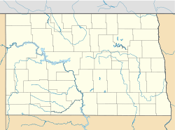
 Charbonneau
Coordinates: 47°51′12″N 103°45′48″W / 47.85333°N 103.76333°WCoordinates: 47°51′12″N 103°45′48″W / 47.85333°N 103.76333°W Country United States State North Dakota County McKenzie Time zone Central (CST) (UTC-6) - Summer (DST) CDT (UTC-5) ZIP codes FIPS code GNIS feature ID Charbonneau is a ghost town in McKenzie County, North Dakota, United States. It was abandoned when the post office was closed in the 1960s.
References
Municipalities and communities of McKenzie County, North Dakota County seat: Watford City Cities 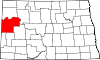
Townships Alex | Antelope Creek | Arnegard | Blue Butte | Charbon | Elm Tree | Grail | Hawkeye | Keene | Randolph | Riverview | Sioux | Tri | Twin Valley | Yellowstone
CDPs East Fairview | Four Bears Village | Mandaree
Unorganized
territoriesCentral McKenzie | East McKenzie | Fort Berthold | North McKenzie | Southeast McKenzie | Southwest McKenzie
Unincorporated
communitiesBanks | Charlson | Cartwright | Charbonneau | Croff | Dore | Grassy Butte | Harding | Johnsons Corner | Keene | Rawson | Schafer | Skaar | Spotted Horn
Categories:- Ghost towns in North Dakota
- Geography of McKenzie County, North Dakota
- North Dakota geography stubs
- United States ghost town stubs


Wikimedia Foundation. 2010.